Map of New Pekin town
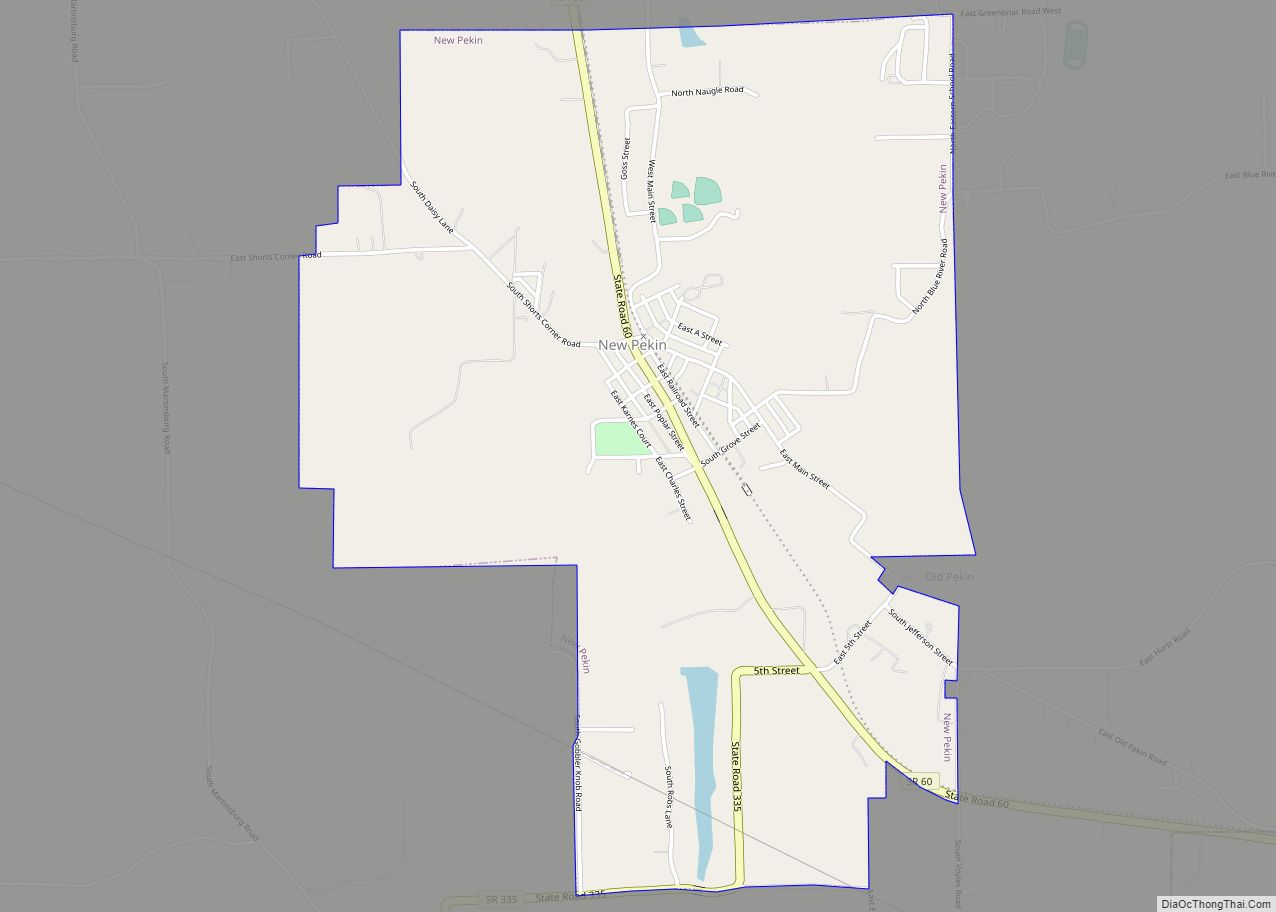
New Pekin is a town in Pierce and Polk townships, Washington County, Indiana, United States. The population was 1,401 at the 2010 census. New Pekin town overview: Name: New Pekin town LSAD Code: 43 LSAD Description: town (suffix) State: Indiana County: Washington County Elevation: 709 ft (216 m) Total Area: 2.40 sq mi (6.23 km²) Land Area: 2.38 sq mi (6.17 km²) Water ... Read more
Map of New Pekin town
Map of New Paris CDP, Indiana
New Paris is a census-designated place (CDP) in Elkhart County, Indiana, United States. The population was 1,494 at the 2010 census. New Paris CDP overview: Name: New Paris CDP LSAD Code: 57 LSAD Description: CDP (suffix) State: Indiana County: Elkhart County Elevation: 810 ft (247 m) Total Area: 1.33 sq mi (3.45 km²) Land Area: 1.33 sq mi (3.45 km²) Water Area: 0.00 sq mi ... Read more
Map of New Paris CDP, Indiana
Map of New Salisbury CDP
New Salisbury is an unincorporated census-designated place (CDP) in Jackson Township, Harrison County, Indiana, United States. As of the 2010 census it had a population of 613. The community is centered on the intersection of State Highway 135 and State Highway 64, about 7 miles (11 km) away from Corydon, the county seat. Businesses in New ... Read more
Map of New Salisbury CDP
Map of New Ross town
New Ross is a town in Walnut Township, Montgomery County, in the U.S. state of Indiana. As of the 2020 census, the town population was 309. New Ross town overview: Name: New Ross town LSAD Code: 43 LSAD Description: town (suffix) State: Indiana County: Montgomery County Elevation: 886 ft (270 m) Total Area: 0.30 sq mi (0.77 km²) Land Area: ... Read more
Map of New Ross town
Map of New Richmond town, Indiana
New Richmond is a town in Coal Creek Township, Montgomery County, in the U.S. state of Indiana. The population was 309 at the 2020 census. New Richmond town overview: Name: New Richmond town LSAD Code: 43 LSAD Description: town (suffix) State: Indiana County: Montgomery County Elevation: 784 ft (239 m) Total Area: 0.19 sq mi (0.50 km²) Land Area: 0.19 sq mi ... Read more
Map of New Richmond town, Indiana
Map of New Whiteland town
New Whiteland is a town in Pleasant Township, Johnson County, Indiana, United States. The population was 5,550 at the 2020 census. New Whiteland town overview: Name: New Whiteland town LSAD Code: 43 LSAD Description: town (suffix) State: Indiana County: Johnson County Elevation: 807 ft (246 m) Total Area: 1.45 sq mi (3.76 km²) Land Area: 1.45 sq mi (3.76 km²) Water Area: 0.00 sq mi ... Read more
Map of New Whiteland town
Map of New Washington CDP, Indiana
New Washington is a census-designated place (CDP) in Clark County, Indiana, United States. As of the 2010 census, the population was 566. New Washington CDP overview: Name: New Washington CDP LSAD Code: 57 LSAD Description: CDP (suffix) State: Indiana County: Clark County Elevation: 719 ft (219 m) Total Area: 5.22 sq mi (13.52 km²) Land Area: 5.21 sq mi (13.49 km²) Water Area: ... Read more
Map of New Washington CDP, Indiana
Map of New Trenton CDP
New Trenton is an unincorporated community and census-designated place (CDP) in Whitewater Township, Franklin County, Indiana. As of the 2010 census it had a population of 252. It has a ZIP code 47035. New Trenton CDP overview: Name: New Trenton CDP LSAD Code: 57 LSAD Description: CDP (suffix) State: Indiana County: Franklin County Elevation: 614 ft ... Read more
Map of New Trenton CDP
Map of Newport town, Indiana
Newport is a town in Vermillion Township, Vermillion County, in the U.S. state of Indiana. The population was 515 at the 2010 census. The town is the county seat of Vermillion County. Newport town overview: Name: Newport town LSAD Code: 43 LSAD Description: town (suffix) State: Indiana County: Vermillion County Elevation: 528 ft (161 m) Total Area: ... Read more
Map of Newport town, Indiana
Map of Newburgh town, Indiana
Newburgh is a borough in Ohio Township, Warrick County, Indiana, United States, along the Ohio River. The population was 3,325 at the 2010 census, although the town is part of the larger Evansville metropolitan area which recorded a population of 342,815, and Ohio Township, which Newburgh shares with nearby Chandler, has a population of 37,749 ... Read more
Map of Newburgh town, Indiana
Map of Newberry town, Indiana
Newberry is a town in Cass Township, Greene County, Indiana, United States. The population was 193 at the 2010 census. It is part of the Bloomington, Indiana Metropolitan Statistical Area. Newberry town overview: Name: Newberry town LSAD Code: 43 LSAD Description: town (suffix) State: Indiana County: Greene County Elevation: 551 ft (168 m) Total Area: 0.48 sq mi (1.24 km²) ... Read more
Map of Newberry town, Indiana
Map of North Crows Nest town
North Crows Nest is a town in Washington Township, Marion County, Indiana, United States. It is approximately 7 miles (11 km) north of downtown Indianapolis. The population was 44 at the 2020 census. It has existed as an “included town” since 1970, when it was incorporated into Indianapolis as part of Unigov. It is part of ... Read more
Map of North Crows Nest town