Map of Noblesville city
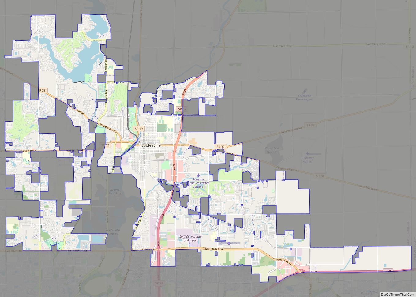
Noblesville is a city in and the county seat of Hamilton County, Indiana, United States, a part of the north Indianapolis suburbs along the White River. The population was 51,969 at the 2010 census making it the state’s 14th largest city/town, up from 19th in 2007. As of 2019 the estimated population was 64,668. The ... Read more
Map of Noblesville city
Map of Newtown town, Indiana
Newtown is a town in Richland Township, Fountain County, Indiana, United States. The population was 256 at the 2010 census. Newtown town overview: Name: Newtown town LSAD Code: 43 LSAD Description: town (suffix) State: Indiana County: Fountain County Elevation: 725 ft (221 m) Total Area: 0.50 sq mi (1.31 km²) Land Area: 0.50 sq mi (1.31 km²) Water Area: 0.00 sq mi (0.00 km²) Total Population: ... Read more
Map of Newtown town, Indiana
Map of North Liberty town, Indiana
North Liberty is a town in Liberty Township, St. Joseph County, in the U.S. state of Indiana. The population was 1,896 at the 2010 Census. North Liberty is part of the South Bend–Mishawaka, IN-MI, Metropolitan Statistical Area. North Liberty town overview: Name: North Liberty town LSAD Code: 43 LSAD Description: town (suffix) State: Indiana County: ... Read more
Map of North Liberty town, Indiana
Map of North Judson town
North Judson is a town in Wayne Township, Starke County, in the U.S. state of Indiana. The population was 1,857 as of the 2020 census. North Judson town overview: Name: North Judson town LSAD Code: 43 LSAD Description: town (suffix) State: Indiana County: Starke County Elevation: 712 ft (217 m) Total Area: 1.11 sq mi (2.87 km²) Land Area: 1.11 sq mi ... Read more
Map of North Judson town
Map of North Manchester town
North Manchester is a town in Chester Township, Wabash County, in the U.S. state of Indiana. The population was 6,112 at the 2010 census. North Manchester town overview: Name: North Manchester town LSAD Code: 43 LSAD Description: town (suffix) State: Indiana County: Wabash County Elevation: 771 ft (235 m) Total Area: 3.63 sq mi (9.39 km²) Land Area: 3.55 sq mi (9.18 km²) ... Read more
Map of North Manchester town
Map of North Vernon city
North Vernon is a city in Jennings County, Indiana, United States. The population was 6,608 as of the 2020 census. North Vernon city overview: Name: North Vernon city LSAD Code: 25 LSAD Description: city (suffix) State: Indiana County: Jennings County Elevation: 719 ft (219 m) Total Area: 7.68 sq mi (19.90 km²) Land Area: 7.67 sq mi (19.88 km²) Water Area: 0.01 sq mi (0.03 km²) ... Read more
Map of North Vernon city
Map of North Terre Haute CDP
North Terre Haute is a census-designated place (CDP) in Otter Creek Township, Vigo County, in the U.S. state of Indiana. The population was 4,305 at the 2010 census. It is part of the Terre Haute Metropolitan Statistical Area. North Terre Haute CDP overview: Name: North Terre Haute CDP LSAD Code: 57 LSAD Description: CDP (suffix) ... Read more
Map of North Terre Haute CDP
Map of North Salem town
North Salem is a town in Eel River Township, Hendricks County, Indiana, United States. The population was 518 at the 2010 Census. North Salem town overview: Name: North Salem town LSAD Code: 43 LSAD Description: town (suffix) State: Indiana County: Hendricks County Elevation: 892 ft (272 m) Total Area: 0.34 sq mi (0.89 km²) Land Area: 0.34 sq mi (0.89 km²) Water Area: ... Read more
Map of North Salem town
Map of Notre Dame CDP
Notre Dame is a census-designated place and unincorporated community north of the city of South Bend in St. Joseph County, in the U.S. state of Indiana. It includes the campuses of three colleges: the University of Notre Dame, Saint Mary’s College, and Holy Cross College. Notre Dame is split between Clay and Portage Townships. As ... Read more
Map of Notre Dame CDP
Map of Norway CDP, Indiana
Norway is a census-designated place (CDP) in Union Township, White County, in the U.S. state of Indiana. The population was 386 at the 2010 census. Norway CDP overview: Name: Norway CDP LSAD Code: 57 LSAD Description: CDP (suffix) State: Indiana County: White County Elevation: 633 ft (193 m) Total Area: 0.96 sq mi (2.48 km²) Land Area: 0.89 sq mi (2.31 km²) Water ... Read more
Map of Norway CDP, Indiana
Map of North Webster town
North Webster is a town in Tippecanoe Township, Kosciusko County, in the U.S. state of Indiana. The population was 1,146 at the 2010 census. North Webster town overview: Name: North Webster town LSAD Code: 43 LSAD Description: town (suffix) State: Indiana County: Kosciusko County Elevation: 879 ft (268 m) Total Area: 0.82 sq mi (2.13 km²) Land Area: 0.81 sq mi (2.10 km²) ... Read more
Map of North Webster town
Map of Odon town
Odon is a town in Madison Township, Daviess County, Indiana, United States. The population was 1,354 at the 2010 census. Odon town overview: Name: Odon town LSAD Code: 43 LSAD Description: town (suffix) State: Indiana County: Daviess County Elevation: 541 ft (165 m) Total Area: 0.94 sq mi (2.43 km²) Land Area: 0.93 sq mi (2.41 km²) Water Area: 0.01 sq mi (0.02 km²) Total Population: ... Read more
Map of Odon town