Map of Alton city, Kansas
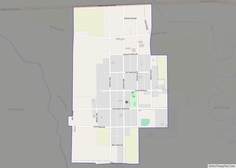
Alton is a city in Osborne County, Kansas, United States. As of the 2020 census, the population of the city was 100. Alton city overview: Name: Alton city LSAD Code: 25 LSAD Description: city (suffix) State: Kansas County: Osborne County Founded: 1870 (Bull City) Incorporated: 1885 Elevation: 1,650 ft (500 m) Total Area: 0.31 sq mi (0.80 km²) Land Area: ... Read more
Map of Alton city, Kansas
Map of Altamont city, Kansas
Altamont is a city in Labette County, Kansas, United States. As of the 2020 census, the population of the city was 1,061. Altamont city overview: Name: Altamont city LSAD Code: 25 LSAD Description: city (suffix) State: Kansas County: Labette County Founded: 1879 Incorporated: 1884 Elevation: 912 ft (278 m) Total Area: 1.93 sq mi (4.99 km²) Land Area: 1.90 sq mi (4.92 km²) ... Read more
Map of Altamont city, Kansas
Map of Americus city, Kansas
Americus is a city in Lyon County, Kansas, United States. As of the 2020 census, the population of the city was 776. It is located northwest of the city of Emporia. Americus is often a waypoint in some Unbound Gravel bike races. Americus city overview: Name: Americus city LSAD Code: 25 LSAD Description: city (suffix) ... Read more
Map of Americus city, Kansas
Map of Andover city, Kansas
Andover is a city in Butler County, Kansas, United States, and a suburb of Wichita. As of the 2020 census, the population of the city was 14,892. Andover is the most populated city in Butler County. Andover city overview: Name: Andover city LSAD Code: 25 LSAD Description: city (suffix) State: Kansas County: Butler County, Sedgwick ... Read more
Map of Andover city, Kansas
Map of Andale city
Andale is a city in Sedgwick County, Kansas, United States. As of the 2020 census, the population of the city was 941. Andale city overview: Name: Andale city LSAD Code: 25 LSAD Description: city (suffix) State: Kansas County: Sedgwick County Founded: 1880s Incorporated: 1901 Elevation: 1,431 ft (436 m) Total Area: 0.57 sq mi (1.49 km²) Land Area: 0.57 sq mi (1.49 km²) ... Read more
Map of Andale city
Map of Argonia city
Argonia is a city in Sumner County, Kansas, United States. As of the 2020 census, the population of the city was 456. Argonia city overview: Name: Argonia city LSAD Code: 25 LSAD Description: city (suffix) State: Kansas County: Sumner County Founded: 1881 Incorporated: 1885 Elevation: 1,257 ft (383 m) Total Area: 0.70 sq mi (1.82 km²) Land Area: 0.70 sq mi (1.82 km²) ... Read more
Map of Argonia city
Map of Arcadia city, Kansas
Arcadia is a city in northeast Crawford County, Kansas, United States. As of the 2020 census, the population of the city was 254. Arcadia city overview: Name: Arcadia city LSAD Code: 25 LSAD Description: city (suffix) State: Kansas County: Crawford County Founded: 1862 Elevation: 837 ft (255 m) Total Area: 0.43 sq mi (1.13 km²) Land Area: 0.43 sq mi (1.13 km²) Water ... Read more
Map of Arcadia city, Kansas
Map of Anthony city, Kansas
Anthony is a city in and the county seat of Harper County, Kansas, United States. As of the 2020 census, the population of the city was 2,108. Anthony city overview: Name: Anthony city LSAD Code: 25 LSAD Description: city (suffix) State: Kansas County: Harper County Founded: 1870s Incorporated: 1879 Elevation: 1,352 ft (412 m) Total Area: 3.21 sq mi ... Read more
Map of Anthony city, Kansas
Map of Arma city
Arma is a city in Crawford County, Kansas, United States. As of the 2020 census, the population of the city was 1,407. Arma city overview: Name: Arma city LSAD Code: 25 LSAD Description: city (suffix) State: Kansas County: Crawford County Founded: 1894 Incorporated: 1909 Elevation: 1,014 ft (309 m) Total Area: 1.16 sq mi (3.00 km²) Land Area: 1.13 sq mi (2.94 km²) ... Read more
Map of Arma city
Map of Arlington city, Kansas
Arlington is a city in Reno County, Kansas, United States. As of the 2020 census, the population of the city was 435. Arlington city overview: Name: Arlington city LSAD Code: 25 LSAD Description: city (suffix) State: Kansas County: Reno County Founded: 1877 Incorporated: 1887 Elevation: 1,595 ft (486 m) Total Area: 1.23 sq mi (3.19 km²) Land Area: 1.23 sq mi (3.19 km²) ... Read more
Map of Arlington city, Kansas
Map of Arkansas City, Kansas
Arkansas City (/ɑːrˈkænzəs/) is a city in Cowley County, Kansas, United States, situated at the confluence of the Arkansas River and Walnut River in the southwestern part of the county. As of the 2020 census, the population of the city was 11,974. The name of this city is not pronounced like the nearby state of ... Read more
Map of Arkansas City, Kansas
Map of Assaria city
Assaria is a city in Saline County, Kansas, United States. As of the 2020 census, the population of the city was 428. Assaria city overview: Name: Assaria city LSAD Code: 25 LSAD Description: city (suffix) State: Kansas County: Saline County Founded: 1879 Incorporated: 1886 Elevation: 1,286 ft (392 m) Total Area: 0.23 sq mi (0.60 km²) Land Area: 0.23 sq mi (0.60 km²) ... Read more
Map of Assaria city