Map of Assaria city
Assaria is a city in Saline County, Kansas, United States. As of the 2020 census, the population of the city was 428. Assaria city overview: Name: Assaria city LSAD Code: 25 LSAD Description: city (suffix) State: Kansas County: Saline County Founded: 1879 Incorporated: 1886 Elevation: 1,286 ft (392 m) Total Area: 0.23 sq mi (0.60 km²) Land Area: 0.23 sq mi (0.60 km²) ... Read more
Map of Assaria city
Map of Ashland city, Kansas
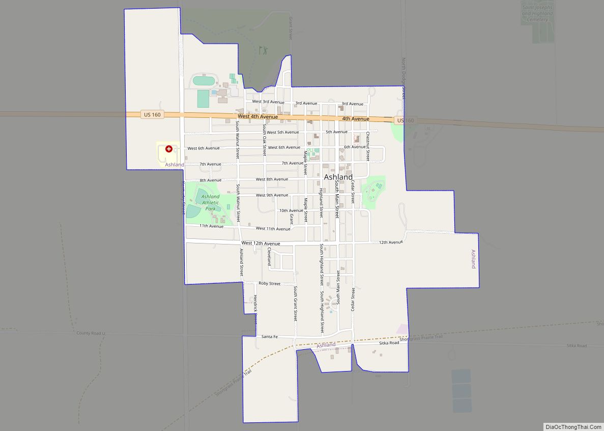
Ashland is a city in and the county seat of Clark County, Kansas, United States. As of the 2020 census, the population of the city was 783. Ashland city overview: Name: Ashland city LSAD Code: 25 LSAD Description: city (suffix) State: Kansas County: Clark County Founded: 1884 Incorporated: 1886 Elevation: 1,975 ft (602 m) Total Area: 1.69 sq mi ... Read more
Map of Ashland city, Kansas
Map of Atlanta city, Kansas
Atlanta is a city in Cowley County, Kansas, United States. As of the 2020 census, the population of the city was 168. Atlanta city overview: Name: Atlanta city LSAD Code: 25 LSAD Description: city (suffix) State: Kansas County: Cowley County Founded: 1885 Incorporated: 1903 Elevation: 1,431 ft (436 m) Total Area: 0.48 sq mi (1.24 km²) Land Area: 0.48 sq mi (1.24 km²) ... Read more
Map of Atlanta city, Kansas
Map of Athol city, Kansas
Athol is a city in Smith County, Kansas, United States. As of the 2020 census, the population of the city was 41. Athol city overview: Name: Athol city LSAD Code: 25 LSAD Description: city (suffix) State: Kansas County: Smith County Founded: 1888 Incorporated: 1911 Elevation: 1,788 ft (545 m) Total Area: 0.18 sq mi (0.48 km²) Land Area: 0.18 sq mi (0.48 km²) ... Read more
Map of Athol city, Kansas
Map of Atchison city
Atchison is a city and county seat of Atchison County, Kansas, United States, along the Missouri River. As of the 2020 census, the population of the city was 10,885. The city is named in honor of US Senator David Rice Atchison from Missouri and was the original eastern terminus of the Atchison, Topeka and Santa ... Read more
Map of Atchison city
Map of Auburn city, Kansas
Auburn is a city in Shawnee County, Kansas, United States. As of the 2020 census, the population of the city was 1,273. Auburn city overview: Name: Auburn city LSAD Code: 25 LSAD Description: city (suffix) State: Kansas County: Shawnee County Founded: 1856 Incorporated: 1963 Elevation: 1,083 ft (330 m) Total Area: 0.70 sq mi (1.81 km²) Land Area: 0.70 sq mi (1.80 km²) ... Read more
Map of Auburn city, Kansas
Map of Atwood city, Kansas
Atwood is a city in and the county seat of Rawlins County, Kansas, United States. As of the 2020 census, the population of the city was 1,290. Atwood city overview: Name: Atwood city LSAD Code: 25 LSAD Description: city (suffix) State: Kansas County: Rawlins County Founded: 1875 Incorporated: 1885 Elevation: 2,858 ft (871 m) Total Area: 1.12 sq mi ... Read more
Map of Atwood city, Kansas
Map of Attica city, Kansas
Attica is a city in Harper County, Kansas, United States. As of the 2020 census, the population of the city was 516. The town was named after the historical region of Attica, in Greece. Attica city overview: Name: Attica city LSAD Code: 25 LSAD Description: city (suffix) State: Kansas County: Harper County Founded: 1884 Incorporated: ... Read more
Map of Attica city, Kansas
Map of Axtell city, Kansas
Axtell is a city in Marshall County, Kansas, United States. As of the 2020 census, the population of the city was 399. Axtell city overview: Name: Axtell city LSAD Code: 25 LSAD Description: city (suffix) State: Kansas County: Marshall County Founded: 1860s Incorporated: 1887 Elevation: 1,365 ft (416 m) Total Area: 0.53 sq mi (1.37 km²) Land Area: 0.52 sq mi (1.36 km²) ... Read more
Map of Axtell city, Kansas
Map of Aurora city, Kansas
Aurora is a city in Cloud County, Kansas, United States. As of the 2020 census, the population of the city was 56. Aurora city overview: Name: Aurora city LSAD Code: 25 LSAD Description: city (suffix) State: Kansas County: Cloud County Founded: 1880s Incorporated: 1910 Elevation: 1,480 ft (450 m) Total Area: 0.10 sq mi (0.26 km²) Land Area: 0.10 sq mi (0.26 km²) ... Read more
Map of Aurora city, Kansas
Map of Augusta city, Kansas
Augusta is a city in Butler County, Kansas, United States. As of the 2020 census, the population of the city was 9,256. Augusta city overview: Name: Augusta city LSAD Code: 25 LSAD Description: city (suffix) State: Kansas County: Butler County Founded: 1868 Incorporated: 1871 Elevation: 1,273 ft (388 m) Total Area: 4.87 sq mi (12.62 km²) Land Area: 4.24 sq mi (10.99 km²) ... Read more
Map of Augusta city, Kansas
Map of Barnard city, Kansas
Barnard is a city in Lincoln County, Kansas, United States. As of the 2020 census, the population of the city was 64. Barnard city overview: Name: Barnard city LSAD Code: 25 LSAD Description: city (suffix) State: Kansas County: Lincoln County Founded: 1888 Incorporated: 1905 Elevation: 1,316 ft (401 m) Total Area: 0.22 sq mi (0.58 km²) Land Area: 0.22 sq mi (0.58 km²) ... Read more
Map of Barnard city, Kansas