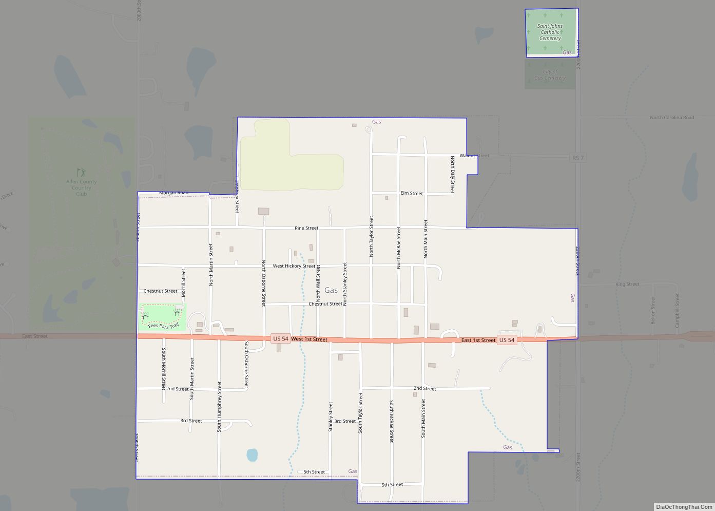
Map of Garnett city
Garnett is a city in and the county seat of Anderson County, Kansas, United States. As of the 2020 census, the population of the city was 3,242. Garnett city overview: Name: Garnett city LSAD Code: 25 LSAD Description: city (suffix) State: Kansas County: Anderson County Incorporated: 1861 Elevation: 1,066 ft (325 m) Total Area: 3.19 sq mi (8.25 km²) Land ... Read more
Map of Garnett city
Map of Gaylord city, Kansas
Gaylord is a city in Smith County, Kansas, United States. As of the 2020 census, the population of the city was 87. Gaylord city overview: Name: Gaylord city LSAD Code: 25 LSAD Description: city (suffix) State: Kansas County: Smith County Founded: 1870 Incorporated: 1886 Elevation: 1,595 ft (486 m) Total Area: 0.26 sq mi (0.66 km²) Land Area: 0.26 sq mi (0.66 km²) ... Read more
Map of Gaylord city, Kansas
Map of Geuda Springs city
Geuda Springs is a city in Cowley and Sumner counties in the U.S. state of Kansas. As of the 2020 census, the population of the city was 158. Geuda Springs city overview: Name: Geuda Springs city LSAD Code: 25 LSAD Description: city (suffix) State: Kansas County: Cowley County, Sumner County Founded: 1870s Incorporated: 1884 Elevation: ... Read more
Map of Geuda Springs city
Map of Geneseo city, Kansas
Geneseo is a city in Rice County, Kansas, United States. As of the 2020 census, the population of the city was 236. Geneseo city overview: Name: Geneseo city LSAD Code: 25 LSAD Description: city (suffix) State: Kansas County: Rice County Founded: 1886 Incorporated: 1887 Elevation: 1,755 ft (535 m) Total Area: 0.58 sq mi (1.51 km²) Land Area: 0.58 sq mi (1.51 km²) ... Read more
Map of Geneseo city, Kansas
Map of Gem city
Gem is a city in Thomas County, Kansas, United States. As of the 2020 census, the population of the city was 98. Gem city overview: Name: Gem city LSAD Code: 25 LSAD Description: city (suffix) State: Kansas County: Thomas County Founded: 1880s Incorporated: 1926 Elevation: 3,094 ft (943 m) Total Area: 0.33 sq mi (0.86 km²) Land Area: 0.33 sq mi (0.86 km²) ... Read more
Map of Gem city
Map of Glasco city, Kansas
Glasco is a city in Cloud County, Kansas, United States. As of the 2020 census, the population of the city was 441. Glasco city overview: Name: Glasco city LSAD Code: 25 LSAD Description: city (suffix) State: Kansas County: Cloud County Founded: 1870 Incorporated: 1886 Elevation: 1,319 ft (402 m) Total Area: 0.33 sq mi (0.86 km²) Land Area: 0.33 sq mi (0.86 km²) ... Read more
Map of Glasco city, Kansas
Map of Glade city
Glade is a city in Phillips County, Kansas, United States. As of the 2020 census, the population of the city was 52. Glade city overview: Name: Glade city LSAD Code: 25 LSAD Description: city (suffix) State: Kansas County: Phillips County Incorporated: 1948 Elevation: 1,808 ft (551 m) Total Area: 0.27 sq mi (0.69 km²) Land Area: 0.27 sq mi (0.69 km²) Water Area: ... Read more
Map of Glade city
Map of Girard city, Kansas
Girard is a city in and the county seat of Crawford County, Kansas, United States. As of the 2020 census, the population of the city was 2,496. Girard city overview: Name: Girard city LSAD Code: 25 LSAD Description: city (suffix) State: Kansas County: Crawford County Founded: 1868 Incorporated: 1869 Elevation: 984 ft (300 m) Total Area: 2.37 sq mi ... Read more
Map of Girard city, Kansas
Map of Goessel city
Goessel is a city in Marion County, Kansas, United States. It was named after Captain Kurt von Goessel (1852–1895) who went down with his ship, the Elbe, in the English Channel after it was rammed. As of the 2020 census, the population of the city was 556. It is located about 11 miles north of ... Read more
Map of Goessel city
Map of Goddard city
Goddard is a city in Sedgwick County, Kansas, United States, and a west suburb of Wichita. As of the 2020 census, the population of the city was 5,084. Goddard city overview: Name: Goddard city LSAD Code: 25 LSAD Description: city (suffix) State: Kansas County: Sedgwick County Founded: 1883 Incorporated: 1910 Elevation: 1,463 ft (446 m) Total Area: ... Read more
Map of Goddard city
Map of Glen Elder city
Glen Elder is a city in Mitchell County, Kansas, United States. As of the 2020 census, the population of the city was 362. Glen Elder city overview: Name: Glen Elder city LSAD Code: 25 LSAD Description: city (suffix) State: Kansas County: Mitchell County Founded: 1871 Incorporated: 1879 Elevation: 1,437 ft (438 m) Total Area: 0.44 sq mi (1.13 km²) Land ... Read more
Map of Glen Elder city
Map of Gorham city, Kansas
Gorham is a city in Russell County, Kansas, United States. As of the 2020 census, the population of the city was 376. Gorham city overview: Name: Gorham city LSAD Code: 25 LSAD Description: city (suffix) State: Kansas County: Russell County Founded: 1886 Incorporated: 1941 Elevation: 1,916 ft (584 m) Total Area: 0.24 sq mi (0.62 km²) Land Area: 0.24 sq mi (0.62 km²) ... Read more
Map of Gorham city, Kansas