Map of Goodland city, Kansas
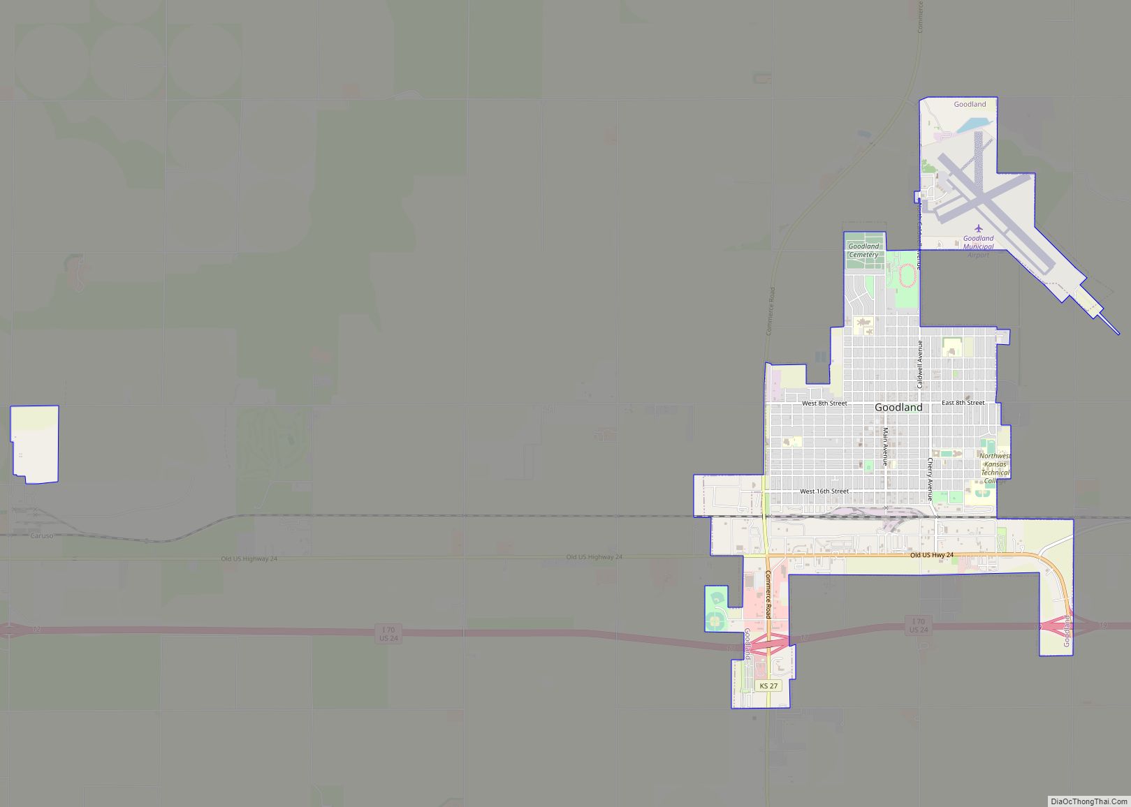
Goodland is a city in and the county seat of Sherman County, Kansas, United States. As of the 2020 census, the population of the city was 4,465. It was named after Goodland, Indiana. Goodland is home to Northwest Kansas Technical College. Goodland city overview: Name: Goodland city LSAD Code: 25 LSAD Description: city (suffix) State: ... Read more
Map of Goodland city, Kansas
Map of Goff city
Goff is a city in Nemaha County, Kansas, United States. As of the 2020 census, the population of the city was 106. Goff city overview: Name: Goff city LSAD Code: 25 LSAD Description: city (suffix) State: Kansas County: Nemaha County Founded: 1880 Incorporated: 1887 Elevation: 1,221 ft (372 m) Total Area: 0.21 sq mi (0.53 km²) Land Area: 0.21 sq mi (0.53 km²) ... Read more
Map of Goff city
Map of Grainfield city
Grainfield is a city in Gove County, Kansas, United States. As of the 2020 census, the population of the city was 322. Grainfield city overview: Name: Grainfield city LSAD Code: 25 LSAD Description: city (suffix) State: Kansas County: Gove County Founded: 1879 Incorporated: 1887 Elevation: 2,812 ft (857 m) Total Area: 0.46 sq mi (1.20 km²) Land Area: 0.46 sq mi (1.20 km²) ... Read more
Map of Grainfield city
Map of Gove City
Gove City, more commonly known as Gove, is a city in and the county seat of Gove County, Kansas, United States. As of the 2020 census, the population of the city was 80. Gove City city overview: Name: Gove City city LSAD Code: 25 LSAD Description: city (suffix) State: Kansas County: Gove County Founded: 1885 ... Read more
Map of Gove City
Map of Grandview Plaza city
Grandview Plaza is a city in Geary County, Kansas, United States. As of the 2020 census, the population of the city was 1,697. Grandview Plaza city overview: Name: Grandview Plaza city LSAD Code: 25 LSAD Description: city (suffix) State: Kansas County: Geary County Elevation: 1,135 ft (346 m) Total Area: 0.86 sq mi (2.23 km²) Land Area: 0.85 sq mi (2.19 km²) Water ... Read more
Map of Grandview Plaza city
Map of Great Bend city, Kansas
Great Bend is a city in and the county seat of Barton County, Kansas, United States. It is named for its location at the point where the course of the Arkansas River bends east then southeast. As of the 2020 census, the population of the city was 14,733. It is home to Barton Community College. ... Read more
Map of Great Bend city, Kansas
Map of Grantville CDP, Kansas
Grantville is an unincorporated community in Jefferson County, Kansas, United States. As of the 2020 census, the population of the community and nearby areas was 182. It is located east of Topeka on the south side of US-24 highway between Barton Rd and KOA/Wilson Rd. Grantville CDP overview: Name: Grantville CDP LSAD Code: 57 LSAD ... Read more
Map of Grantville CDP, Kansas
Map of Green city, Kansas
Green is a city in Clay County, Kansas, United States. As of the 2020 census, the population of the city was 95. Green city overview: Name: Green city LSAD Code: 25 LSAD Description: city (suffix) State: Kansas County: Clay County Incorporated: 1908 Elevation: 1,381 ft (421 m) Total Area: 0.20 sq mi (0.51 km²) Land Area: 0.20 sq mi (0.51 km²) Water Area: ... Read more
Map of Green city, Kansas
Map of Greeley city, Kansas
Greeley is a city in Anderson County, Kansas, United States. As of the 2020 census, the population of the city was 273. Greeley city overview: Name: Greeley city LSAD Code: 25 LSAD Description: city (suffix) State: Kansas County: Anderson County Founded: 1854 Incorporated: 1881 Elevation: 896 ft (273 m) Total Area: 0.35 sq mi (0.91 km²) Land Area: 0.34 sq mi (0.89 km²) ... Read more
Map of Greeley city, Kansas
Map of Grenola city
Grenola is a city in Elk County, Kansas, United States. As of the 2020 census, the population of the city was 151. Grenola city overview: Name: Grenola city LSAD Code: 25 LSAD Description: city (suffix) State: Kansas County: Elk County Founded: 1879 Incorporated: 1880 Elevation: 1,119 ft (341 m) Total Area: 0.47 sq mi (1.21 km²) Land Area: 0.47 sq mi (1.20 km²) ... Read more
Map of Grenola city
Map of Greensburg city, Kansas
Greensburg is a city in, and the county seat of, Kiowa County, Kansas, United States. As of the 2020 United States census, the population of the city was 740. It is home to the world’s largest hand-dug well. On the evening of May 4, 2007, Greensburg was devastated by an EF5 tornado that leveled at ... Read more
Map of Greensburg city, Kansas
Map of Greenleaf city, Kansas
Greenleaf is a city in Washington County, Kansas, United States. As of the 2020 census, the population of the city was 350. Greenleaf city overview: Name: Greenleaf city LSAD Code: 25 LSAD Description: city (suffix) State: Kansas County: Washington County Founded: 1876 Incorporated: 1880 Elevation: 1,417 ft (432 m) Total Area: 0.45 sq mi (1.18 km²) Land Area: 0.45 sq mi (1.17 km²) ... Read more
Map of Greenleaf city, Kansas