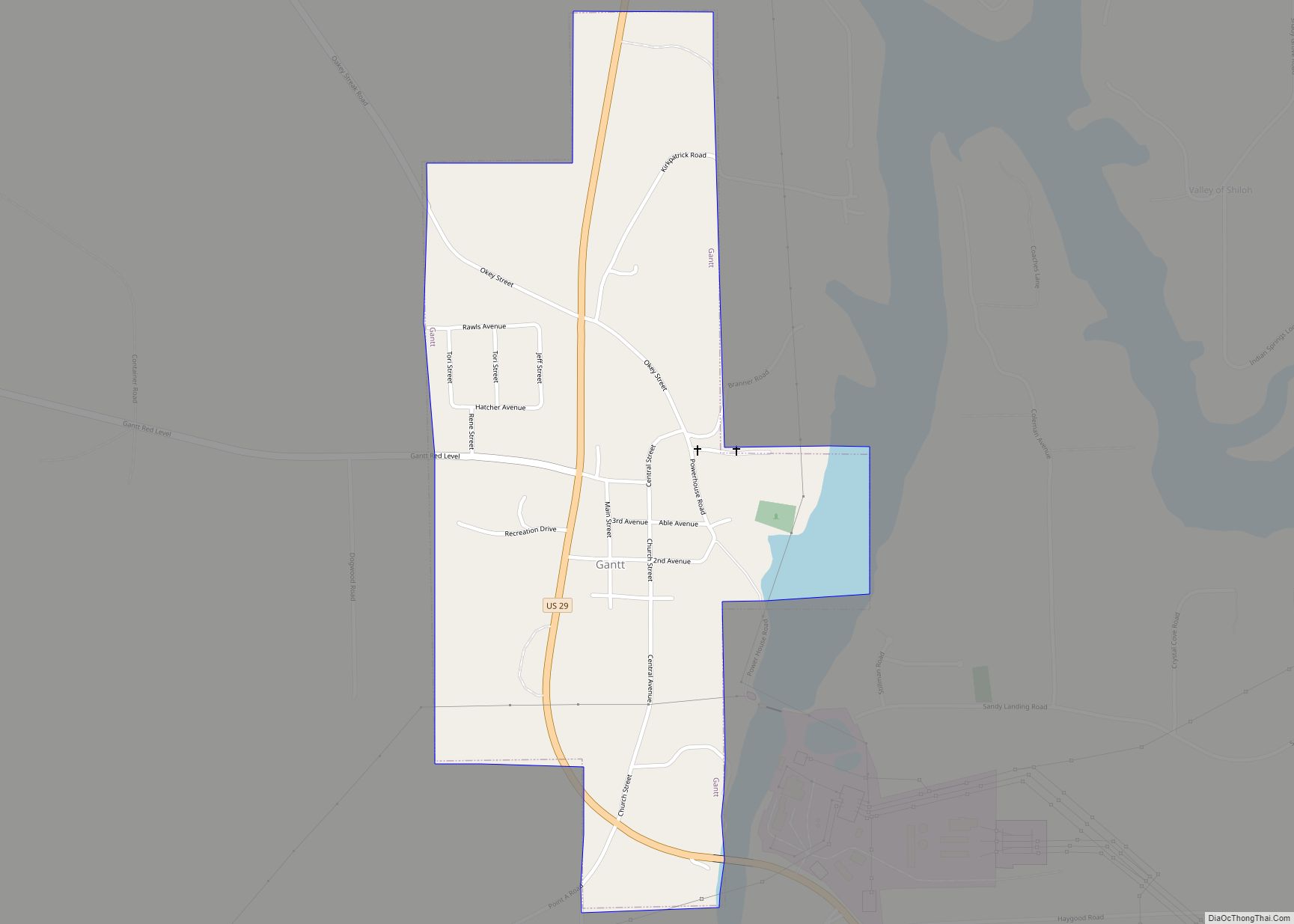
Map of Gallant CDP

Map of Gallant CDP

Gallant, also known as Clear Springs or Greasy Cove, is a census-designated place and unincorporated community in Etowah, and St. Clair counties, Alabama, United States. It lies west of the city of Gadsden, the county seat of Etowah County. As of the 2010 census, its population was 855. It has a post office with the … Read more

Map of Gainesville city

Map of Gainesville town, Alabama

Gainesville is a town in Sumter County, Alabama, United States. Founded in 1832, it was incorporated in 1835. At the 2010 census the population was 208, down from 220. Confederate Lieutenant General Nathan Bedford Forrest surrendered his men near Gainesville on May 19, 1865, at the Civil War’s end. Gainesville town overview: Name: Gainesville town … Read more

Map of Gaylesville town

Map of Gaylesville town

Gaylesville is a town in Cherokee County, Alabama, United States. The population was 144 at the 2010 census. Gaylesville town overview: Name: Gaylesville town LSAD Code: 43 LSAD Description: town (suffix) State: Alabama County: Cherokee County Elevation: 594 ft (181 m) Total Area: 1.42 sq mi (3.69 km²) Land Area: 1.39 sq mi (3.59 km²) Water Area: 0.04 sq mi (0.09 km²) Total Population: 170 Population … Read more

Map of Gardendale city

Map of Gardendale city, Alabama

Gardendale is a city in Jefferson County, Alabama, United States and a northern suburb of Birmingham. The population was 16,044 at the 2020 census. Gardendale city overview: Name: Gardendale city LSAD Code: 25 LSAD Description: city (suffix) State: Alabama County: Jefferson County Incorporated: 1955 Elevation: 679 ft (207 m) Total Area: 22.98 sq mi (59.53 km²) Land Area: 22.98 sq mi (59.52 km²) … Read more

Map of Garden City town

Map of Garden City town, Alabama

Garden City is a town in Cullman and Blount counties in the U.S. state of Alabama. At the 2020 census, the population was 528. Garden City was founded by Johann Cullmann, namesake of Cullman County in 1873 after founding Cullman, Alabama. It was located in Blount County and was incorporated in 1878 (although other sources … Read more

Map of Georgiana town

Map of Georgiana town

Georgiana is a town in Butler County, Alabama, United States. As of the 2010 census, the population of the town was 1,738. Georgiana town overview: Name: Georgiana town LSAD Code: 43 LSAD Description: town (suffix) State: Alabama County: Butler County Elevation: 292 ft (89 m) Total Area: 6.24 sq mi (16.15 km²) Land Area: 6.24 sq mi (16.15 km²) Water Area: 0.00 sq mi (0.00 km²) … Read more

Map of Geneva city

Map of Geneva city, Alabama

Geneva is a city in and the county seat of Geneva County, Alabama, United States. It was incorporated in 1875. It is part of the Dothan, Alabama Metropolitan Statistical Area. Since 1940, it has been the largest city of Geneva County, and had a population of 4,292 as of the 2020 census. Geneva city overview: … Read more

Map of Geiger town

Map of Geiger town

Geiger is a town in Sumter County, Alabama, United States. It incorporated in 1912. At the 2010 census the population was 170, up from 161 in 2000. Geiger town overview: Name: Geiger town LSAD Code: 43 LSAD Description: town (suffix) State: Alabama County: Sumter County Elevation: 167 ft (51 m) Total Area: 0.95 sq mi (2.46 km²) Land Area: 0.94 sq mi … Read more

Map of Gilbertown town

Map of Gilbertown town

Gilbertown is a town in Choctaw County, Alabama, United States. At the 2020 census, the population was 739. Gilbertown town overview: Name: Gilbertown town LSAD Code: 43 LSAD Description: town (suffix) State: Alabama County: Choctaw County Elevation: 89 ft (27 m) Total Area: 10.52 sq mi (27.24 km²) Land Area: 10.52 sq mi (27.24 km²) Water Area: 0.00 sq mi (0.00 km²) Total Population: 739 Population … Read more

Map of Geraldine town

Map of Geraldine town, Alabama

Geraldine is a town in DeKalb County, Alabama, United States. It was incorporated in February 1957. At the 2020 census, the population was 910. Geraldine town overview: Name: Geraldine town LSAD Code: 43 LSAD Description: town (suffix) State: Alabama County: DeKalb County Elevation: 1,145 ft (349 m) Total Area: 3.83 sq mi (9.93 km²) Land Area: 3.82 sq mi (9.90 km²) Water Area: … Read more

Map of Glen Allen town

Map of Glen Allen town, Alabama

Glen Allen is a town located in Fayette and Marion counties in the U.S. state of Alabama. The town incorporated in May 1959. At the 2020 census, the population was 433, down from 510 at the 2010 census. Glen Allen is positioned along the BNSF railway and is near Interstate 22, providing access to multiple … Read more

Map of Goldville town

Map of Goldville town

Goldville is a town in Tallapoosa County, Alabama, United States. The population was 55 at the 2010 census, up from 37 in 2000. Goldville town overview: Name: Goldville town LSAD Code: 43 LSAD Description: town (suffix) State: Alabama County: Tallapoosa County Elevation: 1,014 ft (309 m) Total Area: 1.00 sq mi (2.59 km²) Land Area: 0.99 sq mi (2.55 km²) Water Area: 0.01 sq mi … Read more