Map of Melvern city
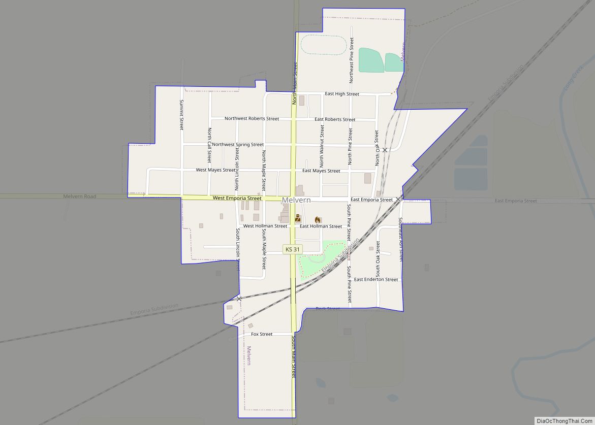
Melvern is a city in Osage County, Kansas, United States, along the Marais des Cygnes River. As of the 2020 census, the population of the city was 356. Melvern city overview: Name: Melvern city LSAD Code: 25 LSAD Description: city (suffix) State: Kansas County: Osage County Founded: 1870 Incorporated: 1883 Elevation: 1,017 ft (310 m) Total Area: ... Read more
Map of Melvern city
Map of Medicine Lodge city
Medicine Lodge is a city in and the county seat of Barber County, Kansas, United States. As of the 2020 census, the population of the city was 1,781. Medicine Lodge city overview: Name: Medicine Lodge city LSAD Code: 25 LSAD Description: city (suffix) State: Kansas County: Barber County Founded: 1873 Incorporated: 1879 Elevation: 1,499 ft (457 m) ... Read more
Map of Medicine Lodge city
Map of Meade city
Meade is a city in and the county seat of Meade County, Kansas, United States. As of the 2020 census, the population of the city was 1,505. Meade city overview: Name: Meade city LSAD Code: 25 LSAD Description: city (suffix) State: Kansas County: Meade County Founded: 1880s Incorporated: 1885 Elevation: 2,497 ft (761 m) Total Area: 1.46 sq mi ... Read more
Map of Meade city
Map of Merriam city
Merriam /ˈmɛriəm/ is a city in Johnson County, Kansas, United States, and part of the Kansas City Metropolitan Area. As of the 2020 census, the population of the city was 11,098. Merriam is included in the Shawnee Mission postal designation. It is also the headquarters of Seaboard Corporation. Merriam city overview: Name: Merriam city LSAD ... Read more
Map of Merriam city
Map of Meriden city, Kansas
Meriden is a city in Jefferson County, Kansas, United States. As of the 2020 census, the population of the city was 744. Meriden city overview: Name: Meriden city LSAD Code: 25 LSAD Description: city (suffix) State: Kansas County: Jefferson County Founded: 1872 Incorporated: 1891 Elevation: 974 ft (297 m) Total Area: 0.77 sq mi (1.98 km²) Land Area: 0.76 sq mi (1.96 km²) ... Read more
Map of Meriden city, Kansas
Map of Menlo city, Kansas
Menlo is a city in Thomas County, Kansas, United States. As of the 2020 census, the population of the city was 33. Menlo city overview: Name: Menlo city LSAD Code: 25 LSAD Description: city (suffix) State: Kansas County: Thomas County Founded: 1880s Incorporated: 1926 Elevation: 2,953 ft (900 m) Total Area: 0.12 sq mi (0.30 km²) Land Area: 0.12 sq mi (0.30 km²) ... Read more
Map of Menlo city, Kansas
Map of Milford city, Kansas
Milford is a city in Geary County, Kansas, United States. As of the 2020 census, the population of the city was 408. Milford city overview: Name: Milford city LSAD Code: 25 LSAD Description: city (suffix) State: Kansas County: Geary County Elevation: 1,155 ft (352 m) Total Area: 0.57 sq mi (1.48 km²) Land Area: 0.57 sq mi (1.48 km²) Water Area: 0.00 sq mi (0.00 km²) ... Read more
Map of Milford city, Kansas
Map of Mildred city, Kansas
Mildred is a unincorporated community in Allen County, Kansas, United States. As of the 2020 census, the population of the community and nearby areas was 25. It is located 7 miles north of Moran along US 59 highway. Mildred city overview: Name: Mildred city LSAD Code: 25 LSAD Description: city (suffix) State: Kansas County: Allen ... Read more
Map of Mildred city, Kansas
Map of Milan city, Kansas
Milan is a city in Sumner County, Kansas, United States. As of the 2020 census, the population of the city was 56. Milan city overview: Name: Milan city LSAD Code: 25 LSAD Description: city (suffix) State: Kansas County: Sumner County Founded: 1880 Incorporated: 1890 Elevation: 1,224 ft (373 m) Total Area: 0.13 sq mi (0.34 km²) Land Area: 0.13 sq mi (0.34 km²) ... Read more
Map of Milan city, Kansas
Map of Minneapolis city, Kansas
Minneapolis is a city in and the county seat of Ottawa County, Kansas, United States. As of the 2020 census, the population of the city was 1,946. Minneapolis city overview: Name: Minneapolis city LSAD Code: 25 LSAD Description: city (suffix) State: Kansas County: Ottawa County Founded: 1860s Incorporated: 1871 Elevation: 1,276 ft (389 m) Total Area: 1.83 sq mi ... Read more
Map of Minneapolis city, Kansas
Map of Miltonvale city
Miltonvale is a city in Cloud County, Kansas, United States. As of the 2020 census, the population of the city was 440. Miltonvale city overview: Name: Miltonvale city LSAD Code: 25 LSAD Description: city (suffix) State: Kansas County: Cloud County Founded: 1881 Incorporated: 1883 Elevation: 1,375 ft (419 m) Total Area: 0.76 sq mi (1.97 km²) Land Area: 0.76 sq mi (1.97 km²) ... Read more
Map of Miltonvale city
Map of Milton CDP, Kansas
Milton is an unincorporated community in Sumner County, Kansas, United States. As of the 2020 census, the population of the community and nearby areas was 155. It is located 4.5 miles (7.2 km) southeast of Norwich at the intersection of N Argonia Rd and W 120th Ave N, next to the railroad. Milton CDP overview: Name: ... Read more
Map of Milton CDP, Kansas