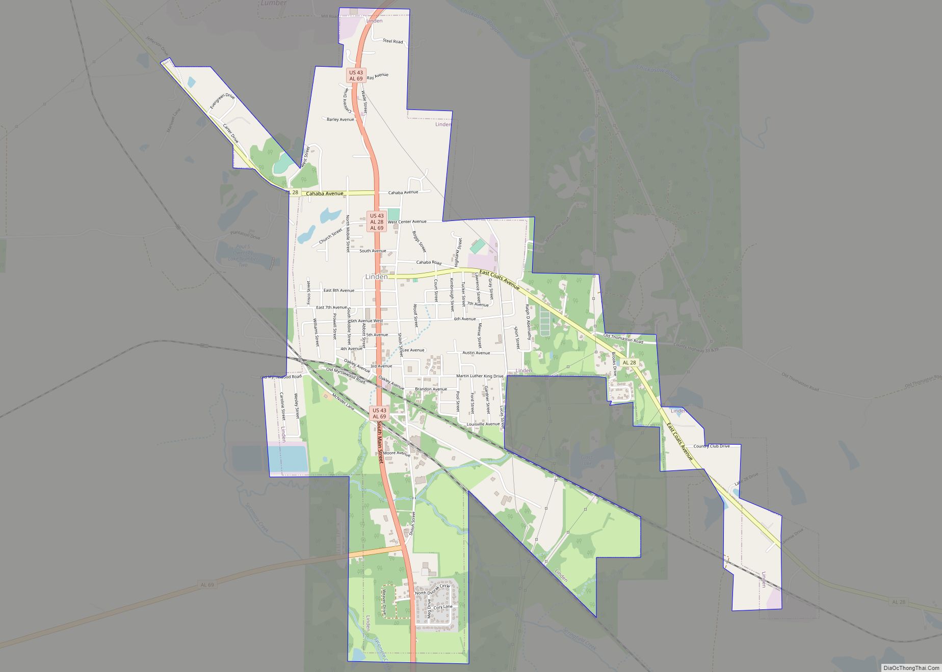
Map of Lincoln city, Alabama
Lincoln is a city in Talladega County, Alabama, United States. It was incorporated in 1911. At the 2020 census, the population was 6,845. It was named for Major General Benjamin Lincoln, who served in the American army during the Revolutionary War. The Talladega Superspeedway, the International Motorsports Hall of Fame and the Talladega Municipal Airport ... Read more
Map of Lincoln city, Alabama
Map of Lillian CDP
Lillian is an unincorporated community and census-designated place in eastern Baldwin County, Alabama, United States. Lillian is located on U.S. Route 98 on the western shore of Perdido Bay, 9.5 miles (15.3 km) east of Elberta. Its eastern edge lies on the Alabama/Florida state line. Lillian CDP overview: Name: Lillian CDP LSAD Code: 57 LSAD Description: ... Read more
Map of Lillian CDP
Map of Lisman town
Lisman is a town in Choctaw County, Alabama, United States. At the 2020 census, the population was 427. Lisman was named after a 19th-century railroad investor at the time of construction of the nearby rail line. Lisman town overview: Name: Lisman town LSAD Code: 43 LSAD Description: town (suffix) State: Alabama County: Choctaw County Elevation: ... Read more
Map of Lisman town
Map of Lipscomb city, Alabama
Lipscomb is a city in western Jefferson County, Alabama. It is part of the Birmingham, Alabama, metropolitan area. At the 2020 census, the population was 2,086. It does not have its own U.S. Post Office or ZIP code, instead sharing the Bessemer ZIP code (35020). Lipscomb city overview: Name: Lipscomb city LSAD Code: 25 LSAD ... Read more
Map of Lipscomb city, Alabama
Map of Lineville city, Alabama
Lineville is a city in Clay County, Alabama, United States. At the 2020 census, the population was 2,489. Lineville city overview: Name: Lineville city LSAD Code: 25 LSAD Description: city (suffix) State: Alabama County: Clay County Elevation: 1,056 ft (322 m) Total Area: 9.74 sq mi (25.23 km²) Land Area: 9.67 sq mi (25.04 km²) Water Area: 0.07 sq mi (0.19 km²) Total Population: 2,489 Population ... Read more
Map of Lineville city, Alabama
Map of Loachapoka town
Loachapoka (/ˌloʊ.tʃəˈpoʊ.kə/) is a town in Lee County, Alabama, United States. It is located less than 1/2 mile west of Auburn and approximately 5 miles (8 km) west of Auburn University, in west-central Lee County. The population was 180 as of the 2010 census. It is part of the Auburn metropolitan area. The name “Loachapoka” means ... Read more
Map of Loachapoka town
Map of Livingston city, Alabama
Livingston is a city in and the county seat of Sumter County, Alabama, United States and the home of the University of West Alabama. By an act of the state legislature, it was incorporated on January 10, 1835. At the 2010 census the population was 3,485, up from 3,297 in 2000. It was named in ... Read more
Map of Livingston city, Alabama
Map of Littleville town
Littleville is a town located on the southern border of Colbert County, Alabama, United States, and extends into Franklin County. It is part of the Florence – Muscle Shoals Metropolitan Statistical Area known as “The Shoals”. As of the 2010 census, the population of the town was 1,011. Littleville town overview: Name: Littleville town LSAD ... Read more
Map of Littleville town
Map of Lookout Mountain CDP, Alabama
Lookout Mountain is a census-designated place in Etowah County, Alabama, United States. Its population was 1,621 as of the 2010 census. Lookout Mountain CDP overview: Name: Lookout Mountain CDP LSAD Code: 57 LSAD Description: CDP (suffix) State: Alabama County: Etowah County Elevation: 833 ft (254 m) Total Area: 15.24 sq mi (39.48 km²) Land Area: 15.23 sq mi (39.45 km²) Water Area: 0.01 sq mi ... Read more
Map of Lookout Mountain CDP, Alabama
Map of Locust Fork town
Locust Fork is a town in Blount County, Alabama, United States. At the 2010 census the population was 1,186 people, up from 1,016 in 2000. Locust Fork town overview: Name: Locust Fork town LSAD Code: 43 LSAD Description: town (suffix) State: Alabama County: Blount County Elevation: 584 ft (178 m) Total Area: 3.89 sq mi (10.07 km²) Land Area: 3.88 sq mi ... Read more
Map of Locust Fork town
Map of Lockhart town, Alabama
Lockhart is a town in Covington County, Alabama, United States. At the 2020 census, the population was 445. Lockhart town overview: Name: Lockhart town LSAD Code: 43 LSAD Description: town (suffix) State: Alabama County: Covington County Elevation: 289 ft (88 m) Total Area: 1.13 sq mi (2.92 km²) Land Area: 1.09 sq mi (2.82 km²) Water Area: 0.04 sq mi (0.10 km²) Total Population: 445 Population ... Read more
Map of Lockhart town, Alabama
Map of Lowndesboro town
Lowndesboro is a town in Lowndes County, Alabama, United States. At the 2010 census the population was 115, down from 140 in 2000. It is part of the Montgomery Metropolitan Statistical Area. Although initially incorporated in 1856 by an act of the state legislature, it lapsed and was not reincorporated until 1962. As of the ... Read more
Map of Lowndesboro town