Map of Monterey CDP, Louisiana
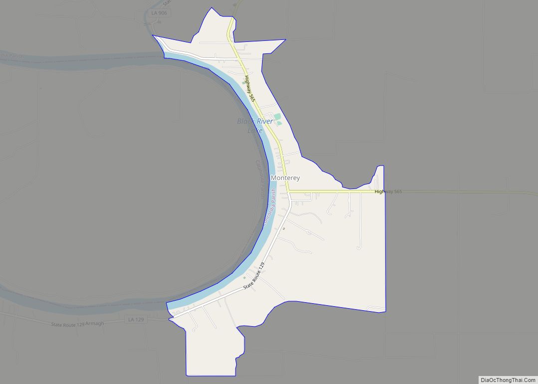
Monterey is an unincorporated community and census-designated place (CDP) in Concordia Parish, Louisiana, United States. As of the 2010 census it had a population of 439. The community is located near the junction of Louisiana Highways 129 and 565 in west central Concordia Parish, southwest of Ferriday. It is also part of the Natchez, MS–LA ... Read more
Map of Monterey CDP, Louisiana
Map of Moonshine CDP
Moonshine is an unincorporated community and census-designated place in St. James Parish, Louisiana, United States. Its population was 194 as of the 2010 census. The community is located on the west bank of the Mississippi River. Moonshine CDP overview: Name: Moonshine CDP LSAD Code: 57 LSAD Description: CDP (suffix) State: Louisiana County: St. James Parish ... Read more
Map of Moonshine CDP
Map of Montz CDP
Montz is a census-designated place (CDP) in St. Charles Parish, Louisiana, United States. The population was 1,120 at the 2000 census, and 2,106 at the 2020 census. Montz CDP overview: Name: Montz CDP LSAD Code: 57 LSAD Description: CDP (suffix) State: Louisiana County: St. Charles Parish Elevation: 16 ft (5 m) Total Area: 2.82 sq mi (7.29 km²) Land Area: ... Read more
Map of Montz CDP
Map of Montpelier village, Louisiana
Montpelier is a village in St. Helena Parish, Louisiana, United States. The population was 286 at the 2010 census. It is part of the Baton Rouge Metropolitan Statistical Area. Montpelier was the parish seat from 1812-1832. Montpelier village overview: Name: Montpelier village LSAD Code: 47 LSAD Description: village (suffix) State: Louisiana County: St. Helena Parish ... Read more
Map of Montpelier village, Louisiana
Map of Morgan City, Louisiana
Morgan City is a small city in St. Mary and lower St. Martin parishes in the U.S. State of Louisiana in the Acadiana region. The population was 12,404 at the 2010 census. Known for being “right in the middle of everywhere”, Morgan City is located 68 miles (109 km) southeast of Lafayette, 64 miles (103 km) south ... Read more
Map of Morgan City, Louisiana
Map of Moreauville village
Moreauville is a village in Avoyelles Parish, Louisiana, United States. The population was 929 at the 2010 census. Moreauville village overview: Name: Moreauville village LSAD Code: 47 LSAD Description: village (suffix) State: Louisiana County: Avoyelles Parish Elevation: 56 ft (17 m) Total Area: 3.03 sq mi (7.84 km²) Land Area: 3.03 sq mi (7.84 km²) Water Area: 0.00 sq mi (0.00 km²) Total Population: 984 Population ... Read more
Map of Moreauville village
Map of Mooringsport town
Mooringsport is an incorporated municipality in the U.S. state of Louisiana, located in Caddo Parish. Part of the Shreveport–Bossier City metropolitan area and located approximately 18 miles (29 km) outside of the principal city of Shreveport, the town of Mooringsport had a population of 748 at the 2020 U.S. census. Mooringsport town overview: Name: Mooringsport town ... Read more
Map of Mooringsport town
Map of Moss Bluff CDP
Moss Bluff is a census-designated place (CDP) in Calcasieu Parish, Louisiana, United States. The population was 12,522 at the 2020 census. Located just north of the city of Lake Charles, it is considered a suburb of that city. Moss Bluff is a burgeoning community, and is one of the communities in Calcasieu Parish besides Lake ... Read more
Map of Moss Bluff CDP
Map of Morse village, Louisiana
Morse is a village in Acadia Parish, Louisiana, United States. The population was 812 at the 2010 census. It is part of the Crowley Micropolitan Statistical Area. Laid out in 1898 on land owned by J. M. Crabtree, Morse was settled by farmers from Illinois and Iowa and incorporated as a village in 1906. The ... Read more
Map of Morse village, Louisiana
Map of Morganza village
Morganza is an incorporated village near the Mississippi River in Pointe Coupee Parish, Louisiana, United States. The population was 610 at the 2010 census, down from 659 in 2000. It is part of the Baton Rouge Metropolitan Statistical Area. The village’s zip code is 70759. The Morganza Spillway, a flood control structure between the Mississippi ... Read more
Map of Morganza village
Map of Napoleonville village
Napoleonville is a village and the parish seat of Assumption Parish, in the U.S. state of Louisiana. The population was 660 at the 2010 census. It is part of the Pierre Part Micropolitan Statistical Area. The village is best known as the location where the film Because of Winn-Dixie, based on Kate DiCamillo’s Newbery Prize-winning ... Read more
Map of Napoleonville village
Map of Mount Lebanon town
Mount Lebanon is a town in Bienville Parish, Louisiana, United States. The population was 83 at the 2010 census. Mount Lebanon town overview: Name: Mount Lebanon town LSAD Code: 43 LSAD Description: town (suffix) State: Louisiana County: Bienville Parish Elevation: 338 ft (103 m) Total Area: 4.03 sq mi (10.44 km²) Land Area: 4.03 sq mi (10.44 km²) Water Area: 0.00 sq mi (0.00 km²) Total ... Read more
Map of Mount Lebanon town