Map of North Hodge village
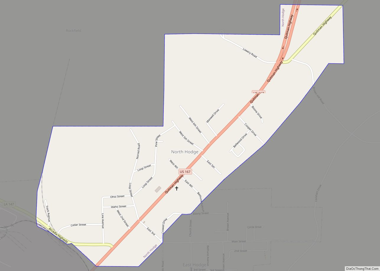
North Hodge is a village in Jackson Parish, Louisiana, United States. The population was 388 at the 2010 census, down from 436 at the 2000 census. It is part of the Ruston Micropolitan Statistical Area. North Hodge village overview: Name: North Hodge village LSAD Code: 47 LSAD Description: village (suffix) State: Louisiana County: Jackson Parish ... Read more
Map of North Hodge village
Map of Oak Hills Place CDP
Oak Hills Place is a census-designated place (CDP) in East Baton Rouge Parish, Louisiana, United States. The population was 8,195 at the 2010 census. It is part of the Baton Rouge Metropolitan Statistical Area, and one of the most affluent suburbs of Baton Rouge. It is in the proposed City of St. George. Oak Hills ... Read more
Map of Oak Hills Place CDP
Map of Oak Grove town, Louisiana
Oak Grove is the parish seat of West Carroll Parish in northeastern Louisiana, United States. The population was 1,441 at the 2020 United States census. Oak Grove town overview: Name: Oak Grove town LSAD Code: 43 LSAD Description: town (suffix) State: Louisiana County: West Carroll Parish Elevation: 121 ft (37 m) Total Area: 1.74 sq mi (4.51 km²) Land Area: ... Read more
Map of Oak Grove town, Louisiana
Map of Norwood village, Louisiana
Norwood is a village in East Feliciana Parish, Louisiana, United States. The population was 322 at the 2010 census. It is part of the Baton Rouge Metropolitan Statistical Area. Norwood village overview: Name: Norwood village LSAD Code: 47 LSAD Description: village (suffix) State: Louisiana County: East Feliciana Parish Elevation: 312 ft (95 m) Total Area: 4.10 sq mi (10.62 km²) ... Read more
Map of Norwood village, Louisiana
Map of Oberlin town, Louisiana
Oberlin is a town in and the parish seat of Allen Parish, Louisiana, United States. The population was 1,770 at the 2010 census. The town is named after Johann Friedrich Oberlin. Oberlin was the home of Ernest S. Clements, a Democratic member of the Louisiana State Senate and, later, the Louisiana Public Service Commission. He ... Read more
Map of Oberlin town, Louisiana
Map of Oakdale city, Louisiana
Oakdale is a city in Allen Parish in south Louisiana, United States. The population was 7,780 at the 2010 census. Oakdale was founded as “Dunnsville” by William T. Dunn. The history of Allen Parish is preserved at the Leatherwood Museum, which reopened on September 27, 2008, in a renovated facility at 202 E. 7th Ave. ... Read more
Map of Oakdale city, Louisiana
Map of Oak Ridge village, Louisiana
Oak Ridge is a village in Morehouse Parish, Louisiana, United States. The population was 142 at the 2000 census. It is part of the Bastrop Micropolitan Statistical Area. Oak Ridge village overview: Name: Oak Ridge village LSAD Code: 47 LSAD Description: village (suffix) State: Louisiana County: Morehouse Parish Elevation: 89 ft (27 m) Total Area: 0.99 sq mi (2.57 km²) ... Read more
Map of Oak Ridge village, Louisiana
Map of Olla town
Olla is a town in northwest La Salle Parish, Louisiana, United States, located in the heart of the Louisiana Central Hill Country. Olla has a federally recognized downtown Historic District and a Louisiana historic marker. The population was 1,385 at the 2010 census. Olla Historic District is the site of the annual Central Louisiana Bluegrass ... Read more
Map of Olla town
Map of Old Jefferson CDP
Old Jefferson is a census-designated place (CDP) in East Baton Rouge Parish, Louisiana, United States. The population was 6,980 at the 2010 census, up from 5,631 in 2000. It is part of the Baton Rouge Metropolitan Statistical Area. Old Jefferson CDP overview: Name: Old Jefferson CDP LSAD Code: 57 LSAD Description: CDP (suffix) State: Louisiana ... Read more
Map of Old Jefferson CDP
Map of Oil City town, Louisiana
Oil City is a town in Caddo Parish, Louisiana. The population was 1,008 at the time of the 2010 census. Oil City is located on Louisiana Highway 1, north of Caddo Lake. It is part of the Shreveport–Bossier City Metropolitan Statistical Area. Oil City town overview: Name: Oil City town LSAD Code: 43 LSAD Description: ... Read more
Map of Oil City town, Louisiana
Map of Ossun CDP
Ossun is an unincorporated community and census-designated place in Lafayette Parish, Louisiana, United States. In 2020, its population was 2,145. The community is named after the area of Ossun, France, near Lourdes. Ossun CDP overview: Name: Ossun CDP LSAD Code: 57 LSAD Description: CDP (suffix) State: Louisiana County: Lafayette Parish Elevation: 39 ft (12 m) Total Area: ... Read more
Map of Ossun CDP
Map of Oretta CDP
Oretta is a census-designated place in Beauregard Parish, Louisiana, United States. As of the 2010 census, it had a population of 418. Oretta CDP overview: Name: Oretta CDP LSAD Code: 57 LSAD Description: CDP (suffix) State: Louisiana County: Beauregard Parish Elevation: 108 ft (33 m) Total Area: 2.20 sq mi (5.70 km²) Land Area: 2.20 sq mi (5.70 km²) Water Area: 0.00 sq mi (0.00 km²) ... Read more
Map of Oretta CDP