Map of Opelousas city
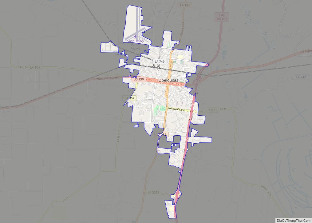
Opelousas (French: Les Opélousas; Spanish: Los Opeluzás) is a small city and the parish seat of St. Landry Parish, Louisiana, United States. Interstate 49 and U.S. Route 190 were constructed with a junction here. According to the 2020 census, Opelousas has a population of 15,786, a 6.53 percent decline since the 2010 census, which had ... Read more
Map of Opelousas city
Map of Paradis CDP
Paradis is a census-designated place (CDP) in St. Charles Parish, Louisiana, United States. The population was 1,252 at the 2000 census and 1,242 in 2020. Paradis CDP overview: Name: Paradis CDP LSAD Code: 57 LSAD Description: CDP (suffix) State: Louisiana County: St. Charles Parish Elevation: 3 ft (0.9 m) Total Area: 6.67 sq mi (17.27 km²) Land Area: 6.43 sq mi (16.65 km²) ... Read more
Map of Paradis CDP
Map of Palmetto village, Louisiana
Palmetto is a village in St. Landry Parish, Louisiana, United States. The population was 188 at the 2000 census. It is part of the Opelousas–Eunice Micropolitan Statistical Area. Palmetto village overview: Name: Palmetto village LSAD Code: 47 LSAD Description: village (suffix) State: Louisiana County: St. Landry Parish Elevation: 36 ft (11 m) Total Area: 0.90 sq mi (2.32 km²) Land ... Read more
Map of Palmetto village, Louisiana
Map of Paincourtville CDP
Paincourtville is a census-designated place (CDP) in Assumption Parish, Louisiana, United States. The population was 911 at the 2010 census. Paincourtville CDP overview: Name: Paincourtville CDP LSAD Code: 57 LSAD Description: CDP (suffix) State: Louisiana County: Assumption Parish Elevation: 16 ft (5 m) Total Area: 1.74 sq mi (4.50 km²) Land Area: 1.74 sq mi (4.50 km²) Water Area: 0.00 sq mi (0.00 km²) Total Population: ... Read more
Map of Paincourtville CDP
Map of Paulina CDP
Paulina is an unincorporated community and census-designated place in St. James Parish, Louisiana, United States. Its population was 1,178 as of the 2010 census. The community is located on the east bank of the Mississippi River in the eastern part of the parish, west of Lutcher and across the river from Vacherie. Paulina has a ... Read more
Map of Paulina CDP
Map of Patterson city, Louisiana
Patterson is a city in St. Mary Parish, Louisiana, United States. The population was 6,112 at the 2010 census. It is part of the Morgan City Micropolitan Statistical Area. Patterson city overview: Name: Patterson city LSAD Code: 25 LSAD Description: city (suffix) State: Louisiana County: St. Mary Parish Elevation: 10 ft (3 m) Total Area: 2.52 sq mi (6.54 km²) ... Read more
Map of Patterson city, Louisiana
Map of Parks village, Louisiana
Parks is a village in St. Martin Parish, Louisiana, United States. The population was 653 at the 2010 census, and 696 at the 2020 population estimates program. It is part of the Lafayette metropolitan statistical area. Parks village overview: Name: Parks village LSAD Code: 47 LSAD Description: village (suffix) State: Louisiana County: St. Martin Parish ... Read more
Map of Parks village, Louisiana
Map of Pine Prairie village
Pine Prairie is a village in Evangeline Parish, Louisiana, United States. The population was 1,610 at the 2010 census, up from 1,087 in 2000. Pine Prairie village overview: Name: Pine Prairie village LSAD Code: 47 LSAD Description: village (suffix) State: Louisiana County: Evangeline Parish Elevation: 121 ft (37 m) Total Area: 1.62 sq mi (4.20 km²) Land Area: 1.61 sq mi (4.18 km²) ... Read more
Map of Pine Prairie village
Map of Pierre Part CDP
Pierre Part (French: Ville de Pierre Part) is a census-designated place (CDP) in Assumption Parish, Louisiana, United States. The population was 3,169 at the 2010 census, making it the most populous community in Assumption Parish. With 39.3 percent of the population speaking French at home, Pierre Part is the most French town in the United ... Read more
Map of Pierre Part CDP
Map of Pearl River town, Louisiana
Pearl River is a town in St. Tammany Parish in the U.S. state of Louisiana. The population was 2,506 at the 2010 U.S. census, and 2,618 at the 2020 population estimates program. It is part of the New Orleans–Metairie–Kenner metropolitan statistical area. Pearl River town overview: Name: Pearl River town LSAD Code: 43 LSAD Description: ... Read more
Map of Pearl River town, Louisiana
Map of Pitkin CDP, Louisiana
Pitkin is a census-designated place (CDP) in Vernon Parish, Louisiana, United States. Pitkin is approximately 40 miles (64 km) southeast of Leesville, the parish seat. Pitkin is approximately 45 miles (72 km) southwest of the city of Alexandria and about 150 miles (240 km) due west of the Louisiana State Penitentiary (LSP, also known as Angola) in West ... Read more
Map of Pitkin CDP, Louisiana
Map of Pioneer village, Louisiana
Pioneer is a village in West Carroll Parish, Louisiana, United States. The population was 171 at the 2000 census. Former Louisiana Commissioner of Agriculture and Forestry Dave L. Pearce (1952–1956; 1960–1976) attended the former elementary school in Pioneer. Pioneer village overview: Name: Pioneer village LSAD Code: 47 LSAD Description: village (suffix) State: Louisiana County: West ... Read more
Map of Pioneer village, Louisiana