Map of Fitchburg city, Massachusetts
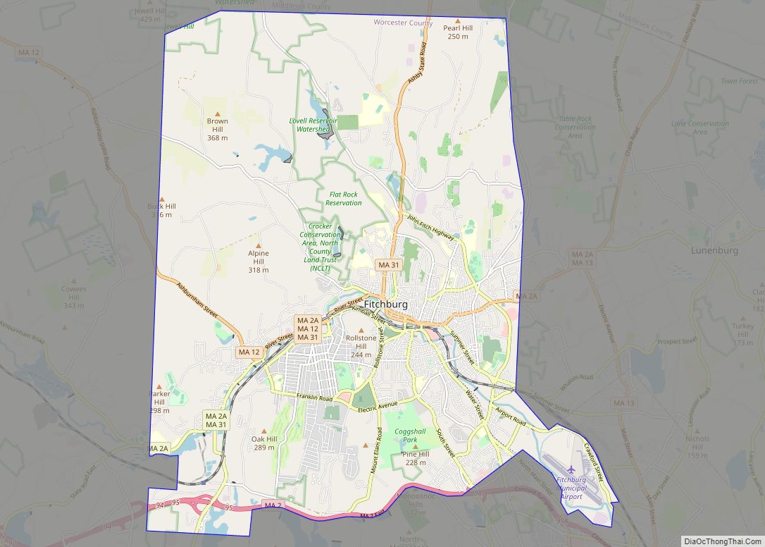
Fitchburg is a city in northern Worcester County, Massachusetts, United States. The third-largest city in the county, its population was 41,946 at the 2020 census. Fitchburg is home to Fitchburg State University as well as 17 public and private elementary and high schools. Fitchburg city overview: Name: Fitchburg city LSAD Code: 25 LSAD Description: city ... Read more
Map of Fitchburg city, Massachusetts
Map of Gardner city, Massachusetts
Gardner, officially the City of Gardner, is a city in Worcester County in the Commonwealth of Massachusetts, United States. The population was 21,287 in the 2020 census. Gardner is home of such sites as the Blue Moon Diner, Dunn State Park, Gardner Heritage State Park, and Mount Wachusett Community College. Gardner city overview: Name: Gardner ... Read more
Map of Gardner city, Massachusetts
Map of Franklin Town city
Franklin Town city overview: Name: Franklin Town city LSAD Code: 25 LSAD Description: city (suffix) State: Massachusetts County: Norfolk County FIPS code: 2525172 Online Interactive Map Franklin Town online map. Source: Basemap layers from Google Map, Open Street Map (OSM), Arcgisonline, Wmflabs. Boundary Data from Database of Global Administrative Areas. Franklin Town location map. Where ... Read more
Map of Franklin Town city
Map of Framingham city
Framingham (/ˈfreɪmɪŋhæm/ (listen)) is a city in the Commonwealth of Massachusetts in the United States. Incorporated in 1700, it is located in Middlesex County and the MetroWest subregion of the Greater Boston metropolitan area. The city proper covers 25 square miles (65 km) with a population of 72,362 in 2020, making it the 14th most populous ... Read more
Map of Framingham city
Map of Great Barrington CDP
Great Barrington is a census-designated place (CDP) located in the town of Great Barrington in Berkshire County, Massachusetts, United States. The population was 2,231 at the 2010 census, out of 7,104 in the entire town of Great Barrington. Great Barrington CDP overview: Name: Great Barrington CDP LSAD Code: 57 LSAD Description: CDP (suffix) State: Massachusetts ... Read more
Map of Great Barrington CDP
Map of Granby CDP, Massachusetts
Granby is a census-designated place (CDP) comprising the main village in the town of Granby in Hampshire County, Massachusetts, United States. The population of the CDP was 1,368 at the 2010 census, out of a total town population of 6,240. It is part of the Springfield, Massachusetts Metropolitan Statistical Area. Granby CDP overview: Name: Granby ... Read more
Map of Granby CDP, Massachusetts
Map of Gloucester city, Massachusetts
Gloucester (/ˈɡlɒstər/) is a city in Essex County, Massachusetts, in the United States. It sits on Cape Ann and is a part of Massachusetts’s North Shore. The population was 29,729 at the 2020 U.S. Census. An important center of the fishing industry and a popular summer destination, Gloucester consists of an urban core on the ... Read more
Map of Gloucester city, Massachusetts
Map of Green Harbor-Cedar Crest CDP
Green Harbor-Cedar Crest CDP overview: Name: Green Harbor-Cedar Crest CDP LSAD Code: 57 LSAD Description: CDP (suffix) State: Massachusetts County: Plymouth County FIPS code: 2527147 Online Interactive Map Green Harbor-Cedar Crest online map. Source: Basemap layers from Google Map, Open Street Map (OSM), Arcgisonline, Wmflabs. Boundary Data from Database of Global Administrative Areas. Green Harbor-Cedar ... Read more
Map of Green Harbor-Cedar Crest CDP
Map of Groton CDP, Massachusetts
Groton is a census-designated place (CDP) in the town of Groton in Middlesex County, Massachusetts, United States. The population was 1,124 at the 2010 census. Groton CDP overview: Name: Groton CDP LSAD Code: 57 LSAD Description: CDP (suffix) State: Massachusetts County: Middlesex County Elevation: 331 ft (101 m) Total Area: 1.67 sq mi (4.33 km²) Land Area: 1.67 sq mi (4.33 km²) Water ... Read more
Map of Groton CDP, Massachusetts
Map of Greenfield Town city
Greenfield Town city overview: Name: Greenfield Town city LSAD Code: 25 LSAD Description: city (suffix) State: Massachusetts County: Franklin County FIPS code: 2527100 Online Interactive Map Greenfield Town online map. Source: Basemap layers from Google Map, Open Street Map (OSM), Arcgisonline, Wmflabs. Boundary Data from Database of Global Administrative Areas. Greenfield Town location map. Where ... Read more
Map of Greenfield Town city
Map of Harwich Center CDP
Harwich Center is a census-designated place (CDP) in the town of Harwich in Barnstable County, Massachusetts, United States. The population was 1,798 at the 2010 census. Harwich Center CDP overview: Name: Harwich Center CDP LSAD Code: 57 LSAD Description: CDP (suffix) State: Massachusetts County: Barnstable County Total Area: 2.29 sq mi (5.93 km²) Land Area: 2.25 sq mi (5.83 km²) Water ... Read more
Map of Harwich Center CDP
Map of Hanson CDP, Massachusetts
Hanson is a census-designated place (CDP) in the town of Hanson in Plymouth County, Massachusetts, United States. The population was 2,118 at the 2010 census. Hanson CDP overview: Name: Hanson CDP LSAD Code: 57 LSAD Description: CDP (suffix) State: Massachusetts County: Plymouth County Elevation: 98 ft (30 m) Total Area: 2.09 sq mi (5.42 km²) Land Area: 1.83 sq mi (4.75 km²) Water ... Read more
Map of Hanson CDP, Massachusetts