Gloucester (/ˈɡlɒstər/) is a city in Essex County, Massachusetts, in the United States. It sits on Cape Ann and is a part of Massachusetts’s North Shore. The population was 29,729 at the 2020 U.S. Census. An important center of the fishing industry and a popular summer destination, Gloucester consists of an urban core on the north side of the harbor and the outlying neighborhoods of Annisquam, Bay View, Lanesville, Folly Cove, Magnolia, Riverdale, East Gloucester, and West Gloucester.
| Name: | Gloucester city |
|---|---|
| LSAD Code: | 25 |
| LSAD Description: | city (suffix) |
| State: | Massachusetts |
| County: | Essex County |
| Elevation: | 50 ft (15 m) |
| Total Area: | 41.51 sq mi (107.51 km²) |
| Land Area: | 26.19 sq mi (67.84 km²) |
| Water Area: | 15.32 sq mi (39.68 km²) |
| Total Population: | 29,729 |
| Population Density: | 1,135.00/sq mi (438.23/km²) |
| ZIP code: | 01930 |
| Area code: | 351 / 978 |
| FIPS code: | 2526150 |
| GNISfeature ID: | 0615084 |
| Website: | gloucester-ma.gov |
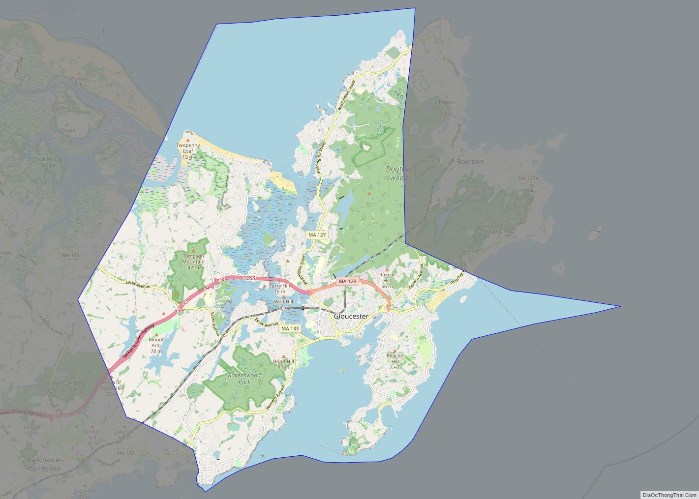
Online Interactive Map
Click on ![]() to view map in "full screen" mode.
to view map in "full screen" mode.
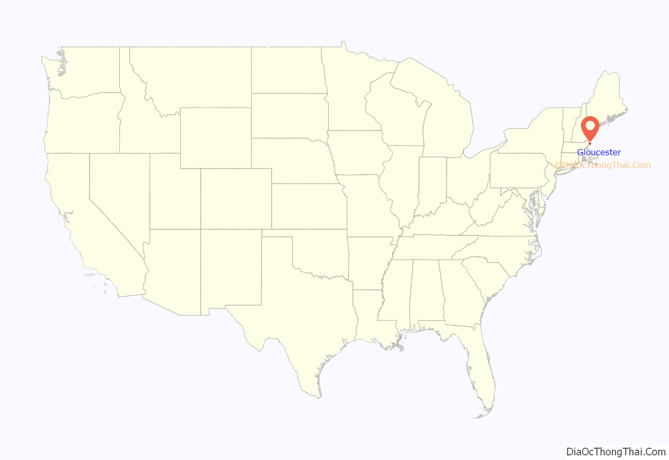
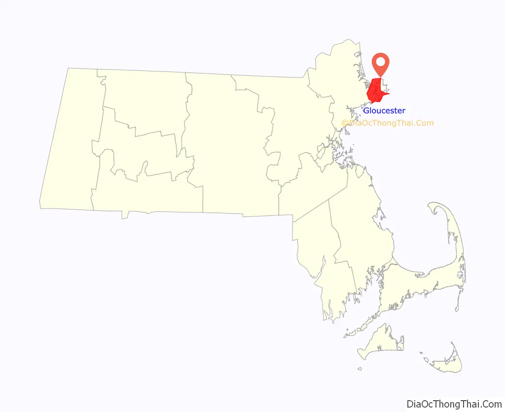
Gloucester location map. Where is Gloucester city?
History
The boundaries of Gloucester originally included the town of Rockport, in an area dubbed “Sandy Bay”. The village separated formally from Gloucester on February 27, 1840. In 1873, Gloucester was reincorporated as a city.
Contact period
Native Americans inhabited what would become northeastern Massachusetts for thousands of years prior to the European colonization of the Americas. At the time of contact, the area was inhabited by Agawam people under sachem Masconomet. Evidence of a village exists on Pole’s Hill in the current Riverdale neighborhood.
In 1606 Samuel de Champlain explored the harbor, and produced the first known map of Gloucester harbor titling it ‘le Beau port’. This map suggests substantial Native American settlement on the shores of the harbor. In 1614 John Smith again explored the area, identifying the indigenous inhabitants as Aggawom. In 1623 men from the Dorchester Company established a permanent fishing outpost in the area.
At the Cape Ann settlement a legal form of government was established, and from that Massachusetts Bay Colony sprung. Roger Conant was the governor under the Cape Ann patent, and as such, has been called the first governor of Massachusetts.
Life in this first settlement was harsh and it was short-lived. Around 1626 the place was abandoned, and the people removed themselves to Naumkeag (in what is now called Salem, Massachusetts), where more fertile soil for planting was to be found. The meetinghouse and governor’s house were even disassembled and relocated to the new place of settlement.
Second English Settlement
At some point in the following years—though no record exists—the area was slowly resettled by English colonists. The town was formally incorporated in 1642. It is at this time that the name “Gloucester” first appears on tax rolls, although in various spellings. The town took its name from the city of Gloucester in southwest England, perhaps from where many of its new occupants originated but more likely because Gloucester, England, was a Parliamentarian stronghold, successfully defended with the aid of the Earl of Essex against the King in the Siege of Gloucester of 1643.
This new permanent settlement focused on the Town Green area, an inlet in the marshes at a bend in the Annisquam River. This area is now the site of Grant Circle, a large traffic rotary at which Massachusetts Route 128 mingles with a major city street (Washington Street/Rt 127). Here the first permanent settlers built a meeting house and therefore focused the nexus of their settlement on the “Island” for nearly 100 years. Unlike other early coastal towns in New England, development in Gloucester was not focused around the harbor as it is today, rather it was inland that people settled first. This is evidenced by the placement of the Town Green nearly two miles from the harbor-front.
The Town Green is also where the settlers built the first school. By Massachusetts Bay Colony Law, any town with 100 families or more had to provide a public schoolhouse. This requirement was met in 1698, with Thomas Riggs standing as the town’s first schoolmaster.
In 1700, the selectmen of Gloucester recognized the claim of Samuel English, grandson of Agawam sachem Masconomet, to the land of the town, and paid him seven pounds for the quitclaim.
The White-Ellery House was erected in 1710 upon the Town Green. It was built at the edge of a marsh for Gloucester’s first settled minister, the Reverend John White (1677–1760).
Early industry included subsistence farming and logging. Because of the poor soil and rocky hills, Cape Ann was not well suited for farming on a large scale. Small family farms and livestock provided the bulk of the sustenance to the population. Fishing, for which the town is known today, was limited to close-to-shore, with families subsisting on small catches as opposed to the great bounties yielded in later years. The fishermen of Gloucester did not command the Grand Banks until the mid-18th century. Historian Christine Heyrman, examining the town’s society between 1690 and 1750, finds that at the beginning community sensibility was weak in a town that was a loose agglomeration of individuals. Commerce and capitalism transformed the society, making it much more closely knit with extended families interlocking in business relationships.
Early Gloucestermen cleared great swaths of the forest of Cape Ann for farm and pasture land, using the timber to build structures as far away as Boston. The rocky moors of Gloucester remained clear for two centuries until the forest reclaimed the land in the 20th century. The inland part of the island became known as the “Commons”, the “Common Village”, or “Dogtown”. Small dwellings lay scattered here amongst the boulders and swamps, along roads that meandered through the hills. These dwellings were at times little more than shanties; only one was even two stories tall. Despite their size, several generations of families were raised in such houses. One feature of the construction of these houses was that under one side of the floor was dug a cellar hole (for the keeping of food), supported by a foundation of laid-stone (without mortar). These cellar holes are still visible today along the trails throughout the inland part of Gloucester; they, and some walls, are all that remain of the village there.
Growth
The town grew, and eventually colonists lived on the opposite side of the Annisquam River. In a time of legally mandated church attendance this was a long way to walk—or row—on a Sunday morning. In 1718 the settlers on the opposite shore of the river split off from the First Parish community at the Green and formed “Second Parish”. While still part of the town of Gloucester, the people of Second, or “West”, Parish now constructed their own meetinghouse and designated their own place of burial, both of which were in the hills near the marshes behind Wingaersheek Beach. The meetinghouse is gone now, but deep in the woods on the Second Parish Road, Old Thompson road, one can still find the stone foundation and memorial altar, as well as scattered stones of the abandoned burial ground.
Other parts of town later followed suit. Third Parish, in northern Gloucester, was founded in 1728. Fourth Parish split off from First Parish in 1742. Finally, in 1754, the people of Sandy Bay (what would later be called Rockport) split off from First Parish to found Fifth Parish. The Sandy Bay church founding was the last religious re-ordering of the colonial period. All of these congregations still exist in some form, with the exception of Fourth Parish, the site of whose meeting house is now a highway.
At one time, there was a thriving granite industry in Gloucester. English writer Harriet Martineau, who visited Gloucester during her travels in the United States in the mid-1830s, commented on the ubiquity of granite there:
Gloucester Road Map
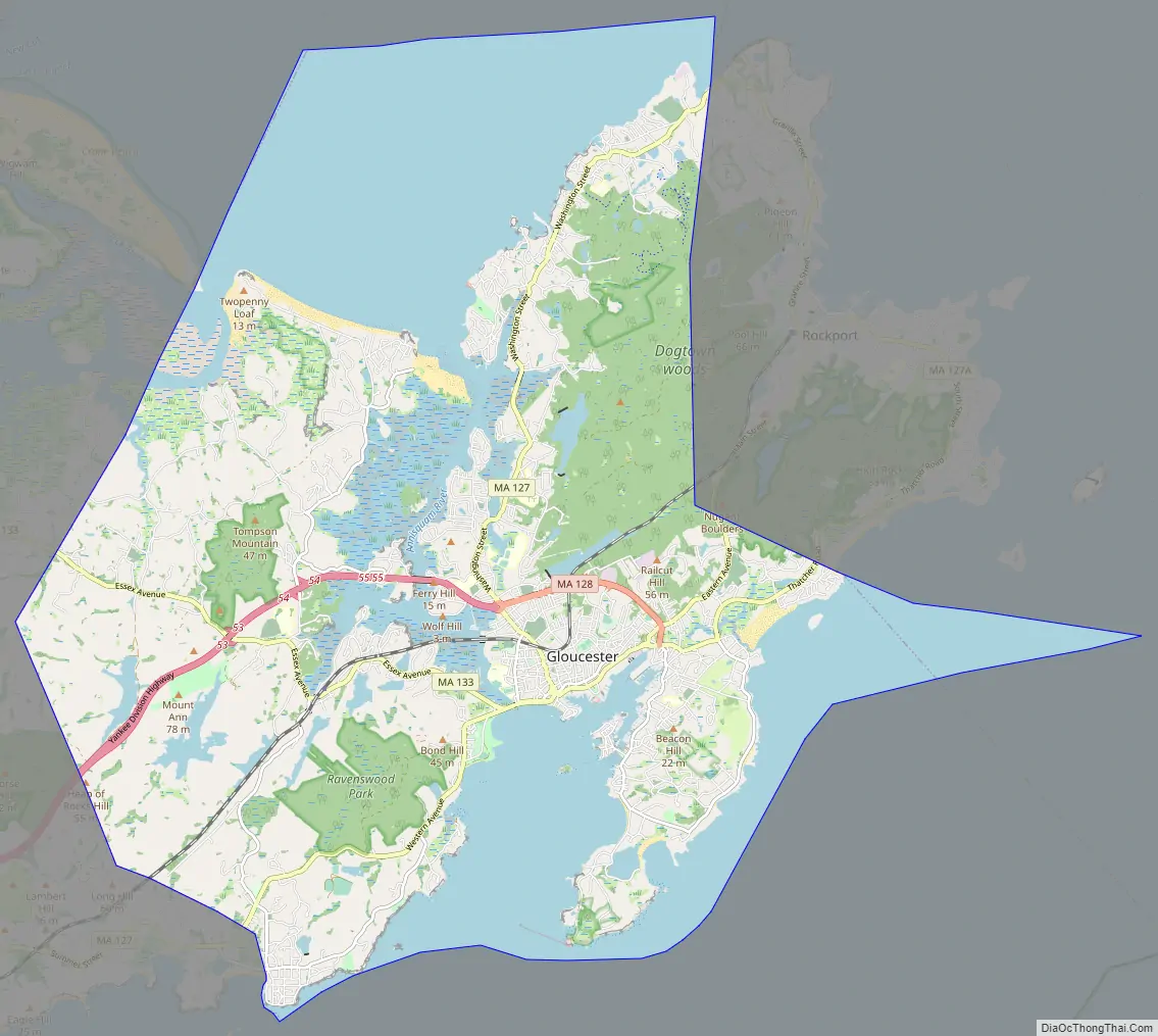
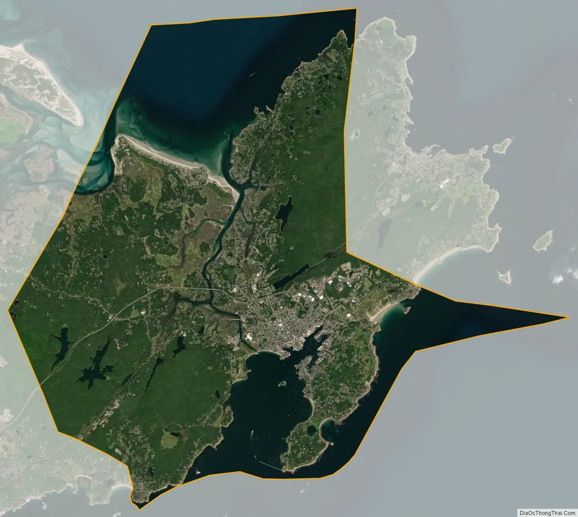
Gloucester city Satellite Map
Geography
Gloucester is located at 42°37′26″N 70°40′32″W / 42.62389°N 70.67556°W / 42.62389; -70.67556 (42.624015, −70.675521). According to the United States Census Bureau, the city has a total area of 41.5 square miles (107.5 km), of which 26.2 square miles (67.8 km) is land and 15.3 square miles (39.6 km), or 36.88%, is water.
Gloucester occupies most of the eastern end of Cape Ann, except for the far tip, which is the town of Rockport. The city is split in half by the Annisquam River, which flows northward through the middle of the city into Ipswich Bay. At its south end it is connected to Gloucester Harbor by the Blynman Canal. The land along the northwestern shore of the river is marshy, creating several small islands. Gloucester Harbor is divided into several smaller coves, including the Western Harbor (site of the Fisherman’s Memorial) and the Inner Harbor (home to the Gloucester fishing fleet). The eastern side of Gloucester Harbor is divided from the rest of Massachusetts Bay by Eastern Point, extending some 2 miles (3 km) outward from the mainland. There are several parks in the city, the largest of which are Ravenswood Park, Stage Fort Park and Mount Ann Park.
Gloucester lies between Ipswich Bay to the north and Massachusetts Bay to the south. The city is bordered on the east by Rockport, and on the west by Ipswich, Essex and Manchester-by-the-Sea to the west. (The town line with Ipswich is located across Essex Harbor, and as such there is no land connection between the towns.) Gloucester lies 16 miles (26 km) east-northeast of Salem and 31 miles (50 km) northeast of Boston. Gloucester lies at the eastern terminus of Route 128, which ends at Route 127A. Route 127A begins at Route 127 just east of the Route 128 terminus, heading into Rockport before terminating there. Route 127 enters from Manchester-by-the-Sea before crossing the Blynman Canal and passing through downtown towards Rockport. It then re-enters Gloucester near Folly Cove, running opposite of its usual north–south orientation towards its terminus at Route 128. Route 133 also terminates within the city, entering from Essex and terminating just west of the Blynman Canal at Route 127. Besides the bridge over the Blynman Canal, there are only two other connections between the eastern and western halves of town, the A. Piatt Andrew Memorial Bridge, carrying Route 128, and the Boston & Maine Railroad Bridge, just north of the Blynman Canal.
Gloucester is home to the Cape Ann Transportation Authority, which serves the city and surrounding towns. Two stops (in West Gloucester and in downtown Gloucester) provide access to the Newburyport/Rockport Line of the MBTA Commuter Rail, which extends from Rockport along the North Shore to Boston’s North Station. The nearest airport is the Beverly Municipal Airport, with the nearest national and international air service being at Boston’s Logan International Airport.
See also
Map of Massachusetts State and its subdivision: Map of other states:- Alabama
- Alaska
- Arizona
- Arkansas
- California
- Colorado
- Connecticut
- Delaware
- District of Columbia
- Florida
- Georgia
- Hawaii
- Idaho
- Illinois
- Indiana
- Iowa
- Kansas
- Kentucky
- Louisiana
- Maine
- Maryland
- Massachusetts
- Michigan
- Minnesota
- Mississippi
- Missouri
- Montana
- Nebraska
- Nevada
- New Hampshire
- New Jersey
- New Mexico
- New York
- North Carolina
- North Dakota
- Ohio
- Oklahoma
- Oregon
- Pennsylvania
- Rhode Island
- South Carolina
- South Dakota
- Tennessee
- Texas
- Utah
- Vermont
- Virginia
- Washington
- West Virginia
- Wisconsin
- Wyoming