Map of Friendship Heights Village CDP
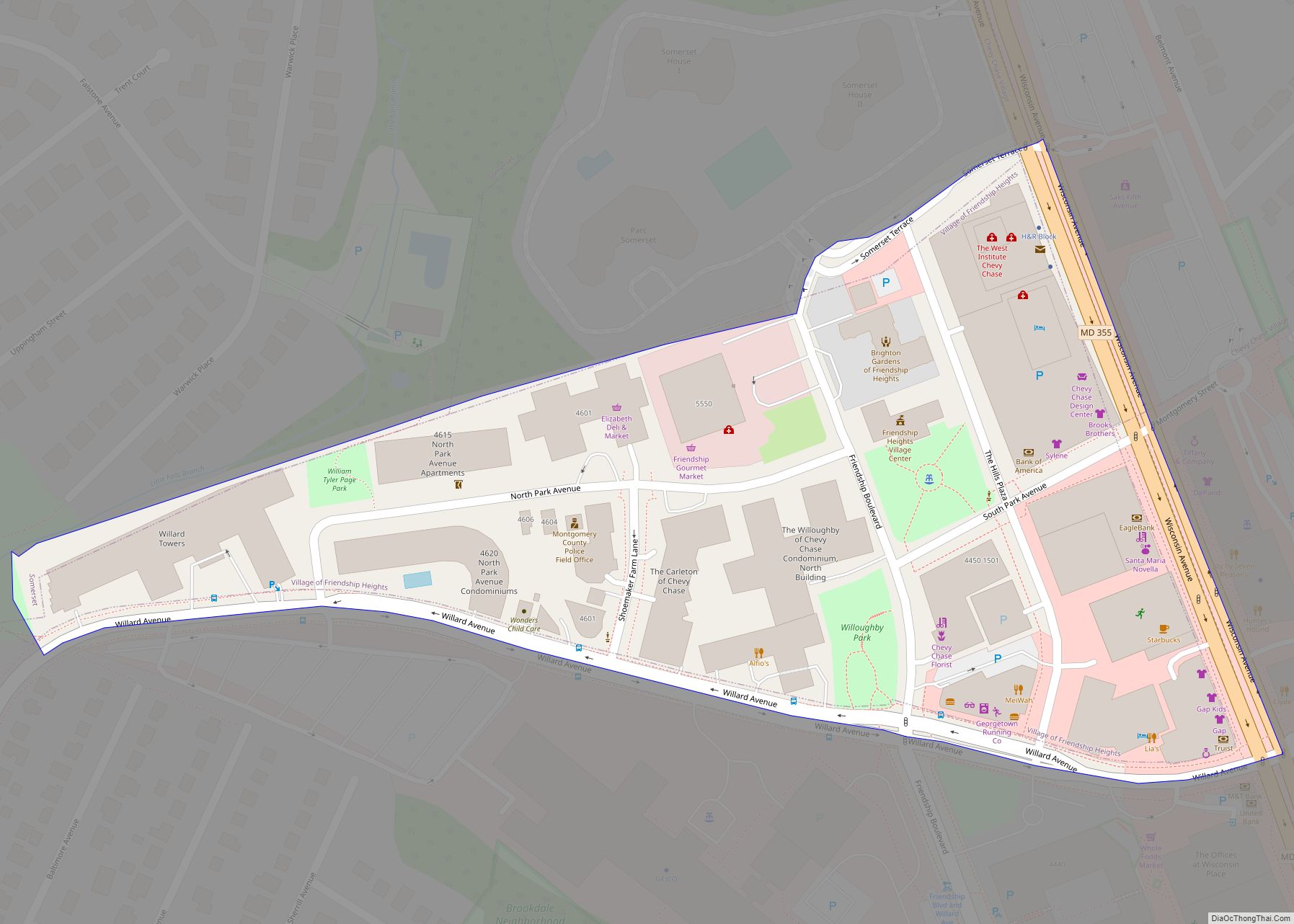
Friendship Heights Village is an urbanized, unincorporated area in Montgomery County, Maryland, United States. Friendship Heights Village is distinct from the Washington, D.C., neighborhood of Friendship Heights). The population was 5,360 at the 2020 census. Friendship Heights Village CDP overview: Name: Friendship Heights Village CDP LSAD Code: 57 LSAD Description: CDP (suffix) State: Maryland County: ... Read more
Map of Friendship Heights Village CDP
Map of Fulton CDP, Maryland
Fulton is a census-designated place located in southern Howard County, Maryland, United States. As of the 2010 census it had a population of 2,049. Fulton CDP overview: Name: Fulton CDP LSAD Code: 57 LSAD Description: CDP (suffix) State: Maryland County: Howard County Elevation: 453 ft (138 m) Total Area: 3.79 sq mi (9.83 km²) Land Area: 3.79 sq mi (9.81 km²) Water Area: ... Read more
Map of Fulton CDP, Maryland
Map of Fruitland city, Maryland
Fruitland is a city in Wicomico County, Maryland, United States. The population was 4,866 at the 2010 census. It is included in the Salisbury, Maryland-Delaware Metropolitan Statistical Area. Fruitland city overview: Name: Fruitland city LSAD Code: 25 LSAD Description: city (suffix) State: Maryland County: Wicomico County Incorporated: 1947 Elevation: 36 ft (11 m) Total Area: 3.86 sq mi (10.00 km²) ... Read more
Map of Fruitland city, Maryland
Map of Frostburg city
Frostburg is a city in Allegany County, Maryland. It is located at the head of the Georges Creek Valley, 8 miles (13 km) west of Cumberland. The town is one of the first cities on the “National Road”, US 40, and the western terminus of the Western Maryland Scenic Railroad. It is part of the Cumberland ... Read more
Map of Frostburg city
Map of Galena town, Maryland
Galena is a town in Kent County, Maryland, United States. The population was 612 at the 2010 census. Galena town overview: Name: Galena town LSAD Code: 43 LSAD Description: town (suffix) State: Maryland County: Kent County Incorporated: 1858 Elevation: 69 ft (21 m) Total Area: 0.36 sq mi (0.93 km²) Land Area: 0.36 sq mi (0.93 km²) Water Area: 0.00 sq mi (0.00 km²) Total Population: ... Read more
Map of Galena town, Maryland
Map of Gaithersburg city
Gaithersburg (/ˈɡeɪθərzbɜːrɡ/ (listen) GAY-thərz-burg), officially the City of Gaithersburg, is a city in Montgomery County, Maryland, United States. At the time of the 2020 U.S. Census, Gaithersburg had a population of 69,657, making it the ninth-largest location in the state. Gaithersburg is located to the northwest of Washington, and is considered a suburb and a ... Read more
Map of Gaithersburg city
Map of Funkstown town
Funkstown is a town in Washington County, Maryland, United States. The population was 904 at the 2010 census. Funkstown town overview: Name: Funkstown town LSAD Code: 43 LSAD Description: town (suffix) State: Maryland County: Washington County Incorporated: 1840 Elevation: 495 ft (151 m) Total Area: 0.55 sq mi (1.43 km²) Land Area: 0.55 sq mi (1.43 km²) Water Area: 0.00 sq mi (0.00 km²) Total Population: ... Read more
Map of Funkstown town
Map of Gambrills CDP
Gambrills refers to two neighboring places in Anne Arundel County, Maryland, United States, located in the Annapolis metro area: the unincorporated community of Gambrills, and the Gambrills census-designated place (CDP). The area was named after Augustine Gambrill, plantation owner. The CDP covers an expansive range that falls within the communities of Crofton, Waugh Chapel, and ... Read more
Map of Gambrills CDP
Map of Galesville CDP, Maryland
Galesville is an unincorporated town and census-designated place (CDP) in Anne Arundel County, Maryland, United States. As of the 2010 census, it had a population of 685. Galesville is located at 38°50’35” north, 76°32’37” west (38.8431707 -76.5435702), along the western shore of the West River, an arm of the Chesapeake Bay. By road it is ... Read more
Map of Galesville CDP, Maryland
Map of Galestown town
Galestown is a town in Dorchester County, Maryland, United States. The population was 138 at the 2010 census. Galestown town overview: Name: Galestown town LSAD Code: 43 LSAD Description: town (suffix) State: Maryland County: Dorchester County Incorporated: 1951 Elevation: 13 ft (4 m) Total Area: 0.26 sq mi (0.66 km²) Land Area: 0.23 sq mi (0.61 km²) Water Area: 0.02 sq mi (0.05 km²) Total Population: ... Read more
Map of Galestown town
Map of Garretts Mill CDP
Garretts Mill is an unincorporated community and census-designated place in Washington County, Maryland, United States. Its population was 234 as of the 2010 census. Garretts Mill CDP overview: Name: Garretts Mill CDP LSAD Code: 57 LSAD Description: CDP (suffix) State: Maryland County: Washington County Total Area: 0.57 sq mi (1.48 km²) Land Area: 0.57 sq mi (1.48 km²) Water Area: 0.00 sq mi ... Read more
Map of Garretts Mill CDP
Map of Garrett Park town
Garrett Park is a town in Montgomery County, Maryland. It was named after a former president of the Baltimore and Ohio Railroad, Robert W. Garrett. The population was 992 at the 2010 census. Garrett Park is home to Garrett Park Elementary School, located just outside the town proper. Garrett Park town overview: Name: Garrett Park ... Read more
Map of Garrett Park town