Map of Forest Glen CDP
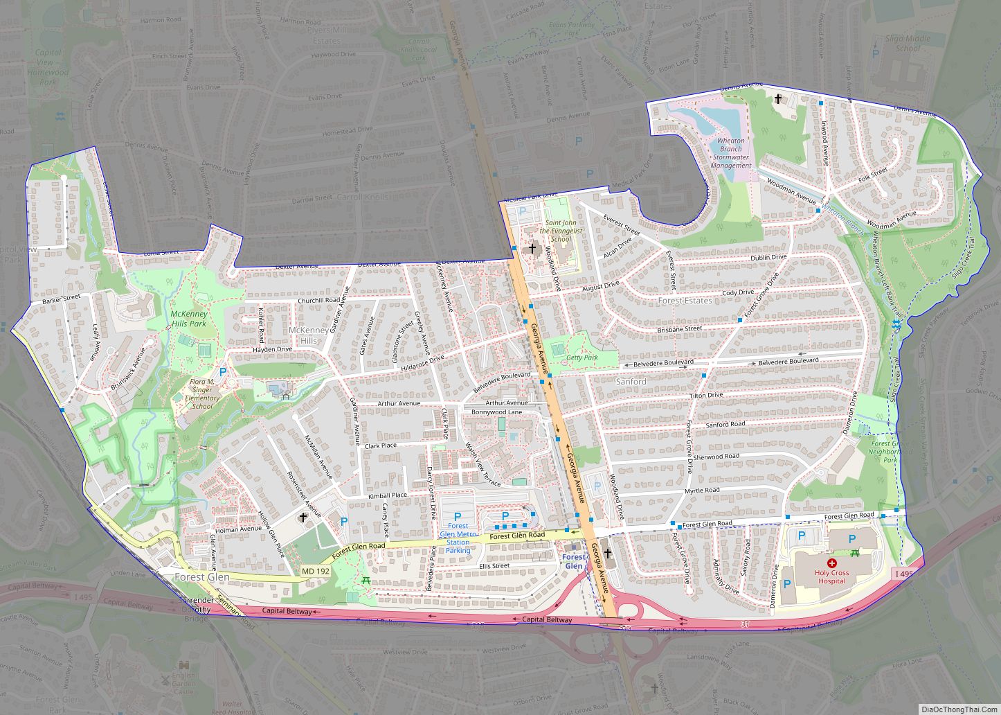
Forest Glen is a census-designated place (CDP) in Montgomery County, Maryland, United States. Its population was 6,897 as of the 2020 census. Forest Glen CDP overview: Name: Forest Glen CDP LSAD Code: 57 LSAD Description: CDP (suffix) State: Maryland County: Montgomery County Elevation: 315 ft (96 m) Total Area: 1.00 sq mi (2.60 km²) Land Area: 1.00 sq mi (2.60 km²) Water Area: ... Read more
Map of Forest Glen CDP
Map of Fort Ritchie CDP
Fort Ritchie is a census-designated place (CDP) in Washington County, Maryland, United States, just south of the Pennsylvania state line. The population was 276 at the 2000 census. Fort Ritchie is a former U.S. military base that closed in September 1998, pursuant to the 1995 Base Realignment and Closure Commission. Blue Ridge Summit, Pennsylvania is ... Read more
Map of Fort Ritchie CDP
Map of Fort Meade CDP, Maryland
Fort Meade is a census-designated place (CDP) in Anne Arundel County, Maryland, United States. The population was 9,327 at the 2010 census. It is the home to the National Security Agency, Central Security Service, United States Cyber Command and the Defense Information Systems Agency, which are located on the U.S. Army post Fort George G. ... Read more
Map of Fort Meade CDP, Maryland
Map of Fort Washington CDP, Maryland
Fort Washington is an unincorporated area and census-designated place in Prince George’s County, Maryland, United States. It borders the Potomac River, situated 20 miles south of the downtown Washington, DC. As of the 2020 census it had a population of 24,261. The Fort Washington community is located west of Maryland Route 210, with some additional ... Read more
Map of Fort Washington CDP, Maryland
Map of Franklin CDP, Maryland
Franklin is an unincorporated community and census-designated place (CDP) in Allegany County, Maryland, United States. As of the 2010 census it had a population of 290. Franklin is located along Maryland routes 36 and 937, 1 mile (1.6 km) north of Westernport. Franklin CDP overview: Name: Franklin CDP LSAD Code: 57 LSAD Description: CDP (suffix) State: ... Read more
Map of Franklin CDP, Maryland
Map of Four Corners CDP, Maryland
Four Corners is a neighborhood and census-designated place (CDP) in Montgomery County, Maryland, United States. Many residents consider the neighborhood a part of Silver Spring, to whose CDP it belonged until 2010. It had a population of 8,316 at the 2020 census. Four Corners CDP overview: Name: Four Corners CDP LSAD Code: 57 LSAD Description: ... Read more
Map of Four Corners CDP, Maryland
Map of Fountainhead-Orchard Hills CDP
Fountainhead-Orchard Hills is a census-designated place (CDP) in Washington County, Maryland, United States. The population was 3,861 at the 2000 census. Fountainhead-Orchard Hills CDP overview: Name: Fountainhead-Orchard Hills CDP LSAD Code: 57 LSAD Description: CDP (suffix) State: Maryland County: Washington County Total Area: 4.42 sq mi (11.44 km²) Land Area: 4.42 sq mi (11.44 km²) Water Area: 0.00 sq mi (0.00 km²) Total Population: ... Read more
Map of Fountainhead-Orchard Hills CDP
Map of Friendly CDP, Maryland
Friendly is an unincorporated area and census-designated place (CDP) in Prince George’s County, Maryland, United States, with an African-American majority population, located a few miles south of Washington, D.C. The population was 9,937 at the 2020 census. Friendly had its own rural post office in the early 20th century, and is now under the mailing ... Read more
Map of Friendly CDP, Maryland
Map of Frenchtown-Rumbly CDP
Frenchtown-Rumbly is a census-designated place in Somerset County, Maryland, United States. The population was 96 at the 2000 census. It is included in the Salisbury, Maryland-Delaware Metropolitan Statistical Area. Frenchtown-Rumbly CDP overview: Name: Frenchtown-Rumbly CDP LSAD Code: 57 LSAD Description: CDP (suffix) State: Maryland County: Somerset County Total Area: 8.39 sq mi (21.74 km²) Land Area: 3.76 sq mi (9.73 km²) ... Read more
Map of Frenchtown-Rumbly CDP
Map of Frederick city, Maryland
Frederick is a city in and the county seat of Frederick County, Maryland, United States. It is located at an important crossroads at the intersection of a major north–south Native American trail and east–west routes to the Chesapeake Bay, both at Baltimore and what became Washington, D.C. and across the Appalachian mountains to the Ohio ... Read more
Map of Frederick city, Maryland
Map of Friendsville town, Maryland
Friendsville is a town in Garrett County, Maryland, United States. The population was 491 at the 2010 census. Friendsville town overview: Name: Friendsville town LSAD Code: 43 LSAD Description: town (suffix) State: Maryland County: Garrett County Incorporated: 1902 Elevation: 1,499 ft (457 m) Total Area: 1.00 sq mi (2.59 km²) Land Area: 1.00 sq mi (2.59 km²) Water Area: 0.00 sq mi (0.00 km²) Total Population: ... Read more
Map of Friendsville town, Maryland
Map of Friendship CDP, Maryland
Friendship is an unincorporated community and census-designated place (CDP) in Anne Arundel County, Maryland, United States. As of the 2010 census, its population was 447. Friendship covers 1.794 square miles (2.887 km), and is located at the southern tip of Anne Arundel County along Maryland Route 2, by which road it is 22 miles (35 km) north ... Read more
Map of Friendship CDP, Maryland