Map of Nanticoke CDP, Maryland
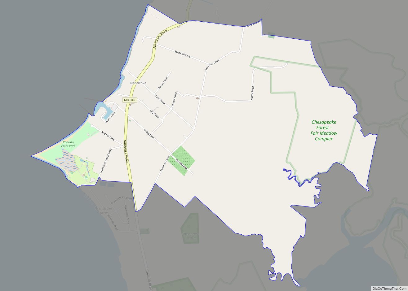
Nanticoke is an unincorporated community and census-designated place in Wicomico County, Maryland, United States. It is part of the Salisbury, Maryland-Delaware Metropolitan Statistical Area. Nanticoke CDP overview: Name: Nanticoke CDP LSAD Code: 57 LSAD Description: CDP (suffix) State: Maryland County: Wicomico County Elevation: 10 ft (3 m) Total Area: 2.63 sq mi (6.83 km²) Land Area: 2.63 sq mi (6.80 km²) Water Area: ... Read more
Map of Nanticoke CDP, Maryland
Map of New Market town, Maryland
New Market is a town in Frederick County, Maryland, United States. The population was 1,525 at the 2020 census. The town bills itself as the “Antiques capital of Maryland”. New Market town overview: Name: New Market town LSAD Code: 43 LSAD Description: town (suffix) State: Maryland County: Frederick County Incorporated: 1878 Elevation: 545 ft (166 m) Total ... Read more
Map of New Market town, Maryland
Map of New Carrollton city
New Carrollton is a city located in central Prince George’s County, Maryland, United States. As of the 2020 census, the population was 13,715. New Carrollton is located 10 miles (16 km) east of central Washington, D.C. The Mayor of New Carrollton is Katrina Dodro. Elected in 2023, Mayor Dodro is the second Black mayor of New ... Read more
Map of New Carrollton city
Map of Naval Academy CDP
Naval Academy is a census-designated place (CDP) in Anne Arundel County, Maryland, United States, which covers the campus of the United States Naval Academy. The population was 4,802 at the 2010 census. Naval Academy CDP overview: Name: Naval Academy CDP LSAD Code: 57 LSAD Description: CDP (suffix) State: Maryland County: Anne Arundel County Total Area: ... Read more
Map of Naval Academy CDP
Map of Nikep CDP
Nikep (originally known as Pekin) is an unincorporated community and census-designated place (CDP) in Allegany County, Maryland, United States. As of the 2020 census it had a population of 95. Nikep is located in the Georges Creek Valley of western Allegany County, along the old route of Maryland Route 36. Lonaconing is 1.6 miles (2.6 km) ... Read more
Map of Nikep CDP
Map of Newark CDP, Maryland
Newark is a census-designated place (CDP) in Worcester County, Maryland, United States. The population was 339 at the 2000 census. It is part of the Salisbury, Maryland-Delaware Metropolitan Statistical Area. Newark CDP overview: Name: Newark CDP LSAD Code: 57 LSAD Description: CDP (suffix) State: Maryland County: Worcester County Elevation: 30 ft (9 m) Total Area: 9.45 sq mi (24.49 km²) ... Read more
Map of Newark CDP, Maryland
Map of New Windsor town, Maryland
New Windsor is a town in Carroll County, Maryland, United States. The population was 1,398 at the 2020 census. It is located 6 miles (10 km) west of Westminster on Maryland Route 31. New Windsor town overview: Name: New Windsor town LSAD Code: 43 LSAD Description: town (suffix) State: Maryland County: Carroll County Incorporated: 1844 Elevation: ... Read more
Map of New Windsor town, Maryland
Map of North Brentwood town
North Brentwood is a town in Prince George’s County, Maryland, United States. The population was 593 at the 2020 census. The municipality of North Brentwood is located north of Washington and is surrounded by the communities of Brentwood, Hyattsville, and Cottage City, and the nearby Mount Rainier. The Town of North Brentwood was incorporated in ... Read more
Map of North Brentwood town
Map of North Bethesda CDP
North Bethesda is an unincorporated, census-designated place in Montgomery County, Maryland, United States, located just north-west of the U.S. capital of Washington, D.C. It had a population of 50,094 as of the 2020 census. Among its neighborhoods, the centrally-located, urbanizing district of White Flint is the commercial and residential hub of North Bethesda. The Pike ... Read more
Map of North Bethesda CDP
Map of North Beach town
North Beach is a town in Calvert County, Maryland, United States. The population was 1,978 at the 2010 U.S. Census. In addition to a boardwalk, North Beach has multiple parks including Wetlands Overlook Park, Sunrise Garden, Callis Park, and the Walton Beach Nature Preserve. It is also the home of the Boys & Girls Club ... Read more
Map of North Beach town
Map of North Kensington CDP
North Kensington is a census-designated place and an unincorporated area in Montgomery County, Maryland, United States. It had a population of 9,497 in 2020. North Kensington CDP overview: Name: North Kensington CDP LSAD Code: 57 LSAD Description: CDP (suffix) State: Maryland County: Montgomery County Elevation: 318 ft (97 m) Total Area: 1.50 sq mi (3.88 km²) Land Area: 1.50 sq mi (3.87 km²) ... Read more
Map of North Kensington CDP
Map of North East town, Maryland
North East is a town in Cecil County, Maryland, United States. It is located between Philadelphia and Baltimore. The population was 3,572 at the 2010 census. The Turkey Point Light Station was listed on the National Register of Historic Places in 2002. The Gilpin’s Falls Covered Bridge was listed in 2008. North East town overview: ... Read more
Map of North East town, Maryland