Map of Morningside town, Maryland
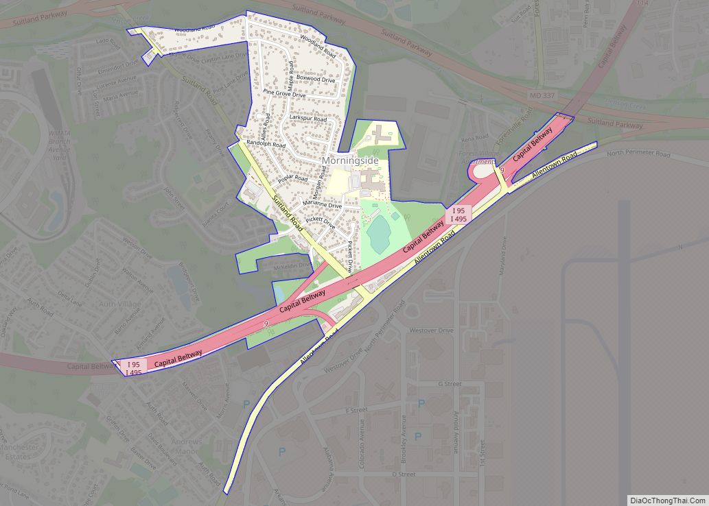
Morningside is an incorporated town in Prince George’s County, Maryland, United States. Per the 2020 census, the population was 1,240. The town developed with the establishment of nearby Andrews Air Force Base and the federal Census Bureau. The government of the town is led by a mayor and town council. Morningside Elementary School and Benjamin ... Read more
Map of Morningside town, Maryland
Map of Mount Lena CDP
Mount Lena is a census-designated place (CDP) in Washington County, Maryland, United States. The population was 501 at the 2000 census. Mount Lena CDP overview: Name: Mount Lena CDP LSAD Code: 57 LSAD Description: CDP (suffix) State: Maryland County: Washington County Elevation: 597 ft (182 m) Total Area: 1.25 sq mi (3.25 km²) Land Area: 1.25 sq mi (3.25 km²) Water Area: 0.00 sq mi ... Read more
Map of Mount Lena CDP
Map of Mount Briar CDP
Mount Briar is an unincorporated community and census-designated place in Washington County, Maryland, United States. Its population was 160 as of the 2010 census. Mount Briar CDP overview: Name: Mount Briar CDP LSAD Code: 57 LSAD Description: CDP (suffix) State: Maryland County: Washington County Total Area: 0.62 sq mi (1.61 km²) Land Area: 0.62 sq mi (1.61 km²) Water Area: 0.00 sq mi ... Read more
Map of Mount Briar CDP
Map of Mount Airy town, Maryland
Mount Airy is a town in Carroll and Frederick counties in the U.S. state of Maryland. It is part of both the Washington Metropolitan Area and Baltimore Metropolitan Area. As of the 2010 census the population was 9,288. Outside the town limits, the surrounding countryside is colloquially referred to as Mount Airy or the “Four-County ... Read more
Map of Mount Airy town, Maryland
Map of Mount Vernon CDP, Maryland
Mount Vernon is a census-designated place (CDP) in Somerset County, Maryland, United States. The population was 761 at the 2000 census. It is included in the Salisbury, Maryland-Delaware Metropolitan Statistical Area. Mount Vernon CDP overview: Name: Mount Vernon CDP LSAD Code: 57 LSAD Description: CDP (suffix) State: Maryland County: Somerset County Elevation: 7 ft (2 m) Total ... Read more
Map of Mount Vernon CDP, Maryland
Map of Mount Savage CDP
Mount Savage is an unincorporated community and census-designated place (CDP) in Allegany County, Maryland, United States. As of the 2010 census it had a population of 873. A small blue-collar community, Mount Savage lies at the base of Big Savage Mountain in the Allegheny Mountains, between the cities of Frostburg and Cumberland. It began as ... Read more
Map of Mount Savage CDP
Map of Mount Rainier city
Mount Rainier /reɪˈnɪər/ is a city in Prince George’s County, Maryland, United States, bordering Washington D.C. The population was 8,333 at the 2020 census. Mount Rainier is contained between the Northwest Branch Anacostia River, Cedar Lane Alley, and 34th Street to the north, 37th Street and 37th Place to the northeast, Upshur Street and Queens ... Read more
Map of Mount Rainier city
Map of Nanticoke Acres CDP
Nanticoke Acres is an unincorporated community and census-designated place in Wicomico County, Maryland, United States. Its population was 103 as of the 2010 census. It is part of the Salisbury, Maryland-Delaware Metropolitan Statistical Area. Nanticoke Acres CDP overview: Name: Nanticoke Acres CDP LSAD Code: 57 LSAD Description: CDP (suffix) State: Maryland County: Wicomico County Elevation: ... Read more
Map of Nanticoke Acres CDP
Map of Myersville town
Myersville is a town in Frederick County, Maryland, United States. The population was 1,626 at the 2010 United States Census. Myersville town overview: Name: Myersville town LSAD Code: 43 LSAD Description: town (suffix) State: Maryland County: Frederick County Incorporated: 1904 Elevation: 673 ft (205 m) Total Area: 1.12 sq mi (2.90 km²) Land Area: 1.12 sq mi (2.90 km²) Water Area: 0.00 sq mi (0.00 km²) ... Read more
Map of Myersville town
Map of Mountain Lake Park town
Mountain Lake Park is a town in Garrett County, Maryland, United States. The population was 2,147 as of the 2020 census. Mountain Lake Park town overview: Name: Mountain Lake Park town LSAD Code: 43 LSAD Description: town (suffix) State: Maryland County: Garrett County Incorporated: 1931 Elevation: 2,454 ft (748 m) Total Area: 1.99 sq mi (5.14 km²) Land Area: 1.92 sq mi ... Read more
Map of Mountain Lake Park town
Map of National CDP
National is an unincorporated community and census-designated place (CDP) in Allegany County, Maryland, United States. As of the 2010 census it had a population of 56. National is located in the Georges Creek Valley of western Allegany County along Maryland Route 936, 4 miles (6 km) south of Frostburg. National CDP overview: Name: National CDP LSAD ... Read more
Map of National CDP
Map of National Harbor CDP
National Harbor is a census-designated place (CDP) in Prince George’s County, Maryland, United States, located along the Potomac River near the Woodrow Wilson Bridge and just south of Washington, D.C. It originated as a 300-acre (1.2 km) multi-use waterfront development. Per the 2020 census, the population was 5,509. National Harbor CDP overview: Name: National Harbor CDP ... Read more
Map of National Harbor CDP