Map of Woodsboro town, Maryland
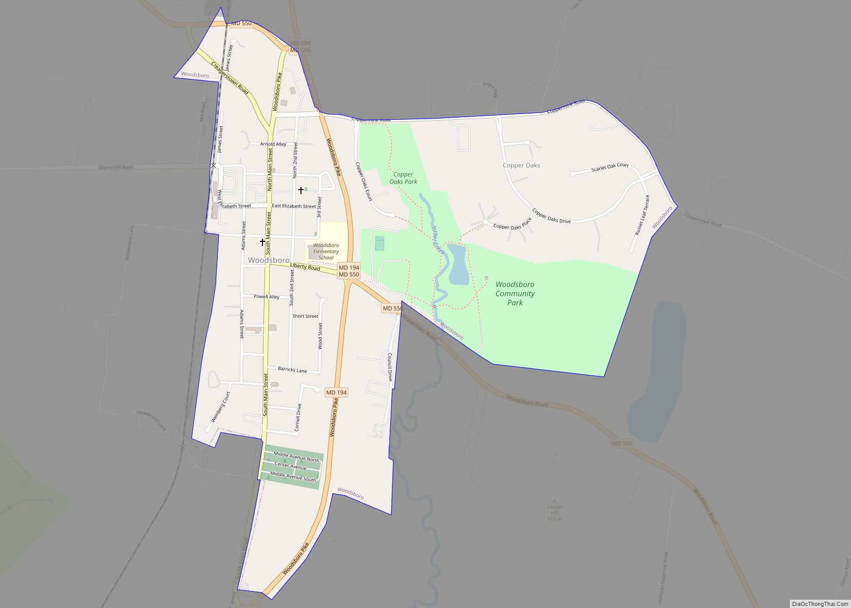
Woodsboro is a town in Frederick County, Maryland, United States that was granted to Joseph Wood in 1693. The population was 1,141 at the 2010 census. Woodsboro town overview: Name: Woodsboro town LSAD Code: 43 LSAD Description: town (suffix) State: Maryland County: Frederick County Founded: 1786 Incorporated: 1836 Elevation: 397 ft (121 m) Total Area: 0.71 sq mi (1.84 km²) ... Read more
Map of Woodsboro town, Maryland
Map of Zihlman CDP
Zihlman (formerly Allegany) is an unincorporated community and census-designated place (CDP) in Allegany County, Maryland, United States. As of the 2010 census it had a population of 362. Zihlman is located along Maryland Route 36, 1.5 miles (2.4 km) northeast of and 500 feet (150 m) lower in elevation than Frostburg. Mount Savage is 3 miles (5 km) ... Read more
Map of Zihlman CDP
Map of Anson CDP, Maine
Anson is a census-designated place (CDP) in the town of Anson in Somerset County, Maine, United States. The population was 818 at the 2000 census. Anson CDP overview: Name: Anson CDP LSAD Code: 57 LSAD Description: CDP (suffix) State: Maine County: Somerset County Elevation: 240 ft (73 m) Total Area: 1.36 sq mi (3.52 km²) Land Area: 1.30 sq mi (3.36 km²) Water ... Read more
Map of Anson CDP, Maine
Map of Alfred CDP, Maine
Alfred is a town in York County, Maine, United States. As of the 2020 census, the town population was 3,073. Alfred is the seat of York County and home to part of the Massabesic Experimental Forest. National Register of Historic Places has two listings in the town, the Alfred Historic District, with 48 houses, and ... Read more
Map of Alfred CDP, Maine
Map of Bath city, Maine
Bath is a city in Sagadahoc County, Maine, in the United States. The population was 8,766 at the 2020 census. It is the county seat of Sagadahoc County, which includes one city and 10 towns. The city is popular with tourists, many drawn by its 19th-century architecture. It is home to the Bath Iron Works ... Read more
Map of Bath city, Maine
Map of Bar Harbor CDP
Bar Harbor is a census-designated place (CDP) in the town of Bar Harbor in Hancock County, Maine, United States. The CDP population was 2,552 at the 2010 census, out of a population of 5,235 in the town of Bar Harbor as a whole. Bar Harbor CDP overview: Name: Bar Harbor CDP LSAD Code: 57 LSAD ... Read more
Map of Bar Harbor CDP
Map of Ashland CDP, Maine
Ashland is a census-designated place (CDP) comprising the main village within the town of Ashland in Aroostook County, Maine, United States. The population of the CDP was 709 at the 2010 census, out of a population of 1,309 for the entire town. Ashland CDP overview: Name: Ashland CDP LSAD Code: 57 LSAD Description: CDP (suffix) ... Read more
Map of Ashland CDP, Maine
Map of Biddeford city
Biddeford is a city in York County, Maine, United States. It is the principal commercial center of York County. Its population was 22,552 at the 2020 census. The twin cities of Saco and Biddeford include the resort communities of Biddeford Pool and Fortunes Rocks. The town is the site of the University of New England ... Read more
Map of Biddeford city
Map of Berwick CDP, Maine
Berwick is a census-designated place (CDP) in the town of Berwick in York County, Maine, United States. The population was 2,187 at the 2010 census, out of a total of 7,246 in the entire town. It is part of the Portland–South Portland–Biddeford, Maine Metropolitan Statistical Area. Berwick CDP overview: Name: Berwick CDP LSAD Code: 57 ... Read more
Map of Berwick CDP, Maine
Map of Belfast city, Maine
Belfast is a city in Waldo County, Maine, in the United States. As of the 2020 census, the city population was 6,938. Located at the mouth of the Passagassawakeag River estuary on Belfast Bay and Penobscot Bay. Belfast is the county seat of Waldo County. Its seaport has a wealth of antique architecture in several ... Read more
Map of Belfast city, Maine
Map of Blue Hill CDP, Maine
Blue Hill is a census-designated place (CDP) in the town of Blue Hill in Hancock County, Maine, United States. The CDP population was 943 as per the 2010 census, out of a population of 2,686 in the town of Blue Hill as a whole. Blue Hill CDP overview: Name: Blue Hill CDP LSAD Code: 57 ... Read more
Map of Blue Hill CDP, Maine
Map of Blaine CDP, Maine
Blaine is a census-designated place (CDP) comprising the main village within the town of Blaine in Aroostook County, Maine, United States. The population of the CDP was 301 at the 2010 census, out of a population of 726 for the entire town. Prior to 2010, the village was part of the Mars Hill-Blaine CDP. Blaine ... Read more
Map of Blaine CDP, Maine