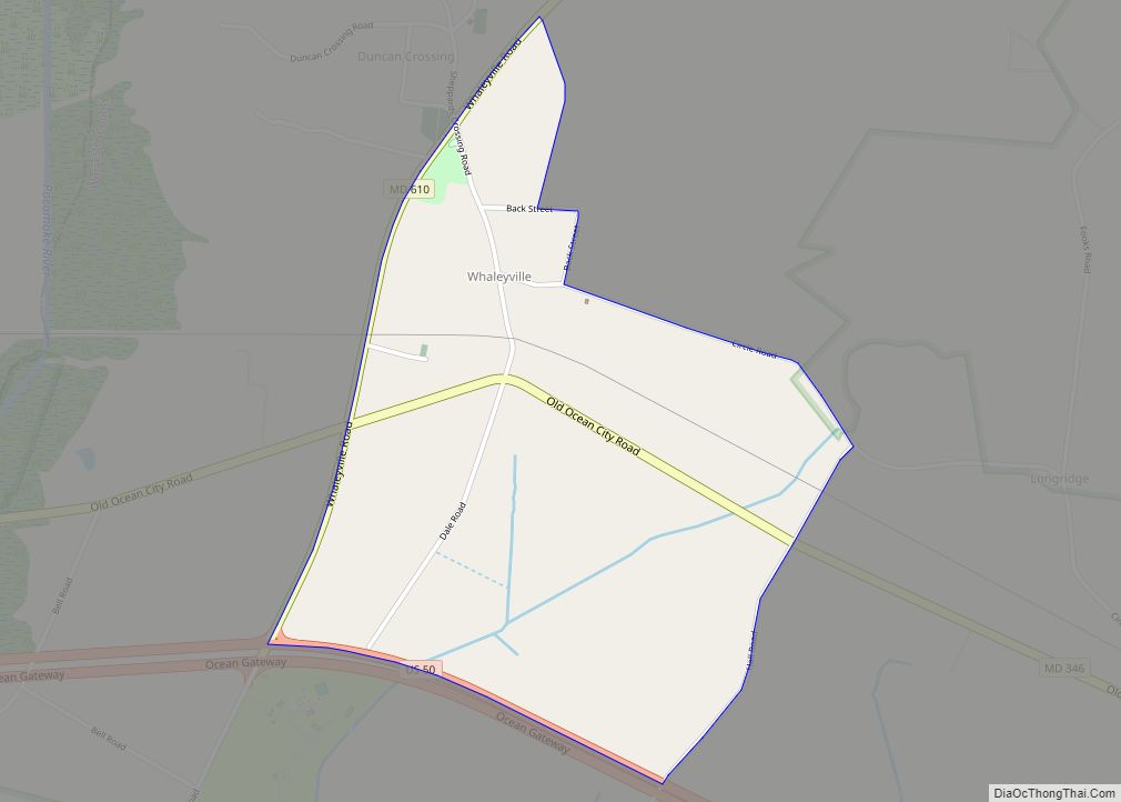
Whaleyville is a census-designated place in Worcester County, Maryland, United States. The population was 149 at the 2010 census. It is part of the Salisbury, Maryland-Delaware Metropolitan Statistical Area. Whaleyville CDP overview: Name: Whaleyville CDP LSAD Code: 57 LSAD Description: CDP (suffix) State: Maryland County: Worcester County Elevation: 30 ft (9 m) Total Area: 1.01 sq mi (2.63 km²) Land ... Read more
Map of US Cities and Places
Willards is a town in Wicomico County, Maryland, United States. The population was 958 at the 2010 census. It is included in the Salisbury, Maryland-Delaware Metropolitan Statistical Area. Willards town overview: Name: Willards town LSAD Code: 43 LSAD Description: town (suffix) State: Maryland County: Wicomico County Incorporated: 1906 Elevation: 33 ft (10 m) Total Area: 1.15 sq mi (2.97 km²) ... Read more
Whitehaven is an unincorporated community and census-designated place in Wicomico County, Maryland, United States. Its population was 43 as of the 2010 census. It is part of the Salisbury, Maryland-Delaware Metropolitan Statistical Area. Whitehaven is home to the Whitehaven Ferry, one of the few remaining public ferries in Maryland, and was once a thriving settlement ... Read more
White Oak is a census-designated place and an unincorporated area in Montgomery County, Maryland, United States. It had a population of 16,347 in 2020. White Oak was known for its Naval Ordnance Laboratory, which was closed in 1994. The headquarters of the Food and Drug Administration now occupies the property, which has been renamed the ... Read more
Wilson-Conococheague is a census-designated place (CDP) in Washington County, Maryland, United States. The population was 2,262 at the 2020 census. Wilson-Conococheague CDP overview: Name: Wilson-Conococheague CDP LSAD Code: 57 LSAD Description: CDP (suffix) State: Maryland County: Washington County Total Area: 4.84 sq mi (12.55 km²) Land Area: 4.72 sq mi (12.22 km²) Water Area: 0.13 sq mi (0.32 km²) Total Population: 2,262 Population Density: ... Read more
Williston is an unincorporated town and census-designated place on the Eastern Shore of the U.S. state of Maryland, in Caroline County. As of the 2010 census it had a population of 155. It is situated between Maryland Route 16 on its eastern edge and the Choptank River on its west. It was originally known as ... Read more
Williamsport is a town in Washington County, Maryland, United States. The population was 1,868 at the 2000 census and 2,137 as of 2010. Williamsport town overview: Name: Williamsport town LSAD Code: 43 LSAD Description: town (suffix) State: Maryland County: Washington County Incorporated: 1823 Elevation: 407 ft (124 m) Total Area: 0.98 sq mi (2.55 km²) Land Area: 0.98 sq mi (2.55 km²) Water ... Read more
Woodmore is an unincorporated area and census-designated place (CDP 86710) in Prince George’s County, Maryland, United States. Per the 2020 census, the population was 4,513. The CDP is located within the boundaries of Route 193 (Enterprise Road) to the west, Church Road to the east, Route 214 (Central Avenue) to the south and Route 50 ... Read more
Woodlawn is an unincorporated area and census-designated place (CDP) in Prince George’s County, Maryland, United States. As of the 2020 census it had a population of 7,541. Woodlawn CDP overview: Name: Woodlawn CDP LSAD Code: 57 LSAD Description: CDP (suffix) State: Maryland County: Prince George’s County Total Area: 1.15 sq mi (2.97 km²) Land Area: 1.15 sq mi (2.96 km²) Water ... Read more
Woodland is an unincorporated community and census-designated place (CDP) in Allegany County, Maryland, United States. As of the 2010 census it had a population of 113. It is located 4 miles (6 km) south of Frostburg and just east of the community called Klondike. Woodland started as a coal town sometime around the beginning of the ... Read more
Yarrowsburg is an unincorporated community and census-designated place in Washington County, Maryland, United States. Its population was 133 as of the 2010 census. Yarrowsburg CDP overview: Name: Yarrowsburg CDP LSAD Code: 57 LSAD Description: CDP (suffix) State: Maryland County: Washington County Total Area: 0.23 sq mi (0.59 km²) Land Area: 0.23 sq mi (0.59 km²) Water Area: 0.00 sq mi (0.00 km²) Total Population: ... Read more
Worton is an unincorporated community and census-designated place (CDP) in Kent County, Maryland, United States. As of the 2010 census it had a population of 249. The Christ Church, Graveyard and Sexton’s House complex was listed on the National Register of Historic Places in 1980. Worton CDP overview: Name: Worton CDP LSAD Code: 57 LSAD ... Read more