Map of Norridgewock CDP
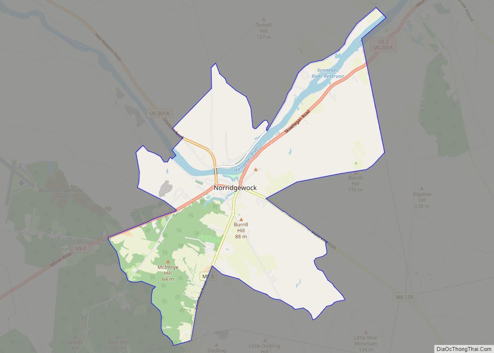
Norridgewock is a census-designated place (CDP) in the town of Norridgewock in Somerset County, Maine, United States. The population was 1,557 at the 2000 census. Norridgewock CDP overview: Name: Norridgewock CDP LSAD Code: 57 LSAD Description: CDP (suffix) State: Maine County: Somerset County Elevation: 200 ft (61 m) Total Area: 11.53 sq mi (29.87 km²) Land Area: 11.07 sq mi (28.68 km²) Water ... Read more
Map of Norridgewock CDP
Map of Old Orchard Beach CDP
Old Orchard Beach is a resort town and census-designated place (CDP) in York County, Maine, United States. The population was 8,960 at the 2020 census. It is part of the Portland−South Portland−Biddeford, Maine Metropolitan Statistical Area. Located on the inner side of Saco Bay on the Atlantic Ocean, the town is a popular seaside resort. ... Read more
Map of Old Orchard Beach CDP
Map of Oakland CDP, Maine
Oakland is a census-designated place (CDP) comprising the main population center in the town of Oakland in Kennebec County, Maine, United States. The population was 2,602 at the 2010 census, out of 6,240 in the entire town of Oakland. Oakland CDP overview: Name: Oakland CDP LSAD Code: 57 LSAD Description: CDP (suffix) State: Maine County: ... Read more
Map of Oakland CDP, Maine
Map of Norway CDP, Maine
Norway is a census-designated place (CDP) in the town of Norway in Oxford County, Maine, United States. The population was 2,623 at the 2000 census. Norway CDP overview: Name: Norway CDP LSAD Code: 57 LSAD Description: CDP (suffix) State: Maine County: Oxford County Elevation: 387 ft (118 m) Total Area: 5.23 sq mi (13.54 km²) Land Area: 5.05 sq mi (13.07 km²) Water ... Read more
Map of Norway CDP, Maine
Map of Oxford CDP, Maine
Oxford is a census-designated place (CDP) in the town of Oxford in Oxford County, Maine, United States. The population was 1,300 at the 2000 census. Oxford CDP overview: Name: Oxford CDP LSAD Code: 57 LSAD Description: CDP (suffix) State: Maine County: Oxford County Elevation: 328 ft (100 m) Total Area: 8.95 sq mi (23.17 km²) Land Area: 8.29 sq mi (21.47 km²) Water ... Read more
Map of Oxford CDP, Maine
Map of Orono CDP, Maine
Orono is a census-designated place (CDP) consisting of the eastern portion of the town of Orono in Penobscot County, Maine, United States. The population of the CDP was 9,474 at the 2010 census. Orono CDP overview: Name: Orono CDP LSAD Code: 57 LSAD Description: CDP (suffix) State: Maine County: Penobscot County Elevation: 125 ft (38 m) Total ... Read more
Map of Orono CDP, Maine
Map of Old Town city
Old Town is a city in Penobscot County, Maine, United States. The population was 7,431 at the 2020 census. The city’s developed area is chiefly located on the relatively large Marsh Island, but its boundaries extend beyond it. The island is surrounded and defined by the Penobscot River to the east and the Stillwater River ... Read more
Map of Old Town city
Map of Randolph CDP, Maine
Randolph is a town and a census-designated place (CDP) in Kennebec County, Maine, United States. The population was 1,743 at the 2020 census. The town was named for Randolph, Massachusetts. Randolph is included in the Augusta, Maine micropolitan New England City and Town Area. Randolph CDP overview: Name: Randolph CDP LSAD Code: 57 LSAD Description: ... Read more
Map of Randolph CDP, Maine
Map of Presque Isle city
Presque Isle (/prɛsk/ PRESK) is the commercial center and largest city in Aroostook County, Maine, United States. The population was 8,797 at the 2020 Census. The city is home to the University of Maine at Presque Isle, Northern Maine Community College, Husson University Presque Isle, Northern Maine Fairgrounds, The Aroostook Centre Mall, and the Presque ... Read more
Map of Presque Isle city
Map of Pittsfield CDP, Maine
Pittsfield is a census-designated place (CDP) in the town of Pittsfield in Somerset County, Maine, United States. The population was 3,217 at the 2000 census. Pittsfield CDP overview: Name: Pittsfield CDP LSAD Code: 57 LSAD Description: CDP (suffix) State: Maine County: Somerset County Elevation: 210 ft (64 m) Total Area: 9.61 sq mi (24.88 km²) Land Area: 9.40 sq mi (24.34 km²) Water ... Read more
Map of Pittsfield CDP, Maine
Map of Rumford CDP
Rumford is a census-designated place (CDP) in the town of Rumford in Oxford County, Maine, United States. The population was 4,795 at the 2000 census. Rumford CDP overview: Name: Rumford CDP LSAD Code: 57 LSAD Description: CDP (suffix) State: Maine County: Oxford County Elevation: 482 ft (147 m) Total Area: 7.98 sq mi (20.68 km²) Land Area: 7.87 sq mi (20.38 km²) Water ... Read more
Map of Rumford CDP
Map of Rockland city, Maine
Rockland is a city in Knox County, Maine, in the United States. As of the 2020 census, the town population was 6,936. It is the county seat of Knox County. The city is a popular tourist destination. It is a departure point for the Maine State Ferry Service to the islands of Penobscot Bay: Vinalhaven, ... Read more
Map of Rockland city, Maine