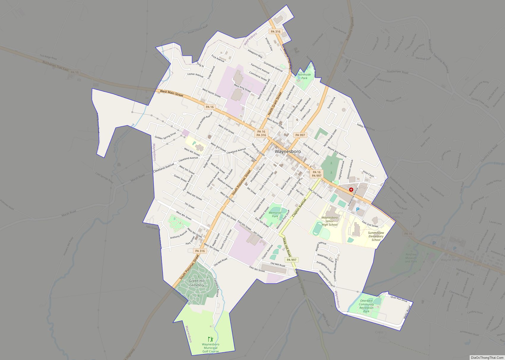
Map of Waymart borough
Waymart is a borough in Wayne County, Pennsylvania, United States. The borough’s population was 1,341 at the time of the 2010 United States Census. Waymart borough overview: Name: Waymart borough LSAD Code: 21 LSAD Description: borough (suffix) State: Pennsylvania County: Wayne County Elevation: 1,873 ft (571 m) Total Area: 2.76 sq mi (7.14 km²) Land Area: 2.69 sq mi (6.97 km²) Water Area: ... Read more
Map of Waymart borough
Map of Waverly CDP, Pennsylvania
Waverly is a census-designated place (CDP) comprising the central community within Waverly Township in Lackawanna County, Pennsylvania, United States. Originally called Abington Center, it was founded in the late 18th century by settlers from Connecticut, along the Warriors’ Path. The population of the CDP at the 2010 census was 604. Waverly CDP overview: Name: Waverly ... Read more
Map of Waverly CDP, Pennsylvania
Map of Wattsburg borough
Wattsburg is a borough in Erie County, Pennsylvania, United States. The population was 352 at the 2020 census. It is part of the Erie Metropolitan Statistical Area. Wattsburg borough overview: Name: Wattsburg borough LSAD Code: 21 LSAD Description: borough (suffix) State: Pennsylvania County: Erie County Total Area: 0.31 sq mi (0.80 km²) Land Area: 0.30 sq mi (0.77 km²) Water Area: ... Read more
Map of Wattsburg borough
Map of Watsontown borough
Watsontown is a borough in Northumberland County, Pennsylvania, United States. The population was 2,351 at the 2010 census. It was named for John Watson, an early settler. Watsontown borough overview: Name: Watsontown borough LSAD Code: 21 LSAD Description: borough (suffix) State: Pennsylvania County: Northumberland County Total Area: 0.93 sq mi (2.42 km²) Land Area: 0.71 sq mi (1.84 km²) Water Area: ... Read more
Map of Watsontown borough
Map of Wellsville borough, Pennsylvania
Wellsville is a borough in York County, Pennsylvania, United States. The population was 299 at the 2020 census. Wellsville borough overview: Name: Wellsville borough LSAD Code: 21 LSAD Description: borough (suffix) State: Pennsylvania County: York County Incorporated: 1892 Elevation: 522 ft (159 m) Total Area: 0.14 sq mi (0.37 km²) Land Area: 0.14 sq mi (0.37 km²) Water Area: 0.00 sq mi (0.00 km²) Total Population: ... Read more
Map of Wellsville borough, Pennsylvania
Map of Wellsboro borough
Wellsboro is a borough in Tioga County, Pennsylvania. The borough was founded by Benjamin Wistar Morris. It is located 52 miles (84 km) northwest of Williamsport. The population was 3,472 at the 2020 census. Early in the 20th century, Wellsboro was the shipping point and trade center for a large area. It had fruit evaporators, flour ... Read more
Map of Wellsboro borough
Map of Wellersburg borough
Wellersburg is a borough in Somerset County, Pennsylvania, United States. It is part of the Johnstown, Pennsylvania, Metropolitan Statistical Area. The population was 181 at the 2010 census. Wellersburg borough overview: Name: Wellersburg borough LSAD Code: 21 LSAD Description: borough (suffix) State: Pennsylvania County: Somerset County Incorporated: 1857 Total Area: 0.81 sq mi (2.10 km²) Land Area: 0.81 sq mi ... Read more
Map of Wellersburg borough
Map of Weissport borough
Weissport is a borough in Carbon County, Pennsylvania. It is part of Northeastern Pennsylvania. As of the 2010 census, it had a population of 412. Weissport borough overview: Name: Weissport borough LSAD Code: 21 LSAD Description: borough (suffix) State: Pennsylvania County: Carbon County Elevation: 630 ft (190 m) Total Area: 0.16 sq mi (0.41 km²) Land Area: 0.14 sq mi (0.35 km²) Water ... Read more
Map of Weissport borough
Map of Weissport East CDP
Weissport East is a census-designated place (CDP) in Franklin Township in Carbon County, Pennsylvania. It is part of Northeastern Pennsylvania. The population was 1,624 at the time of the 2010 census, down from 1,936 at the 2000 census. Weissport East CDP overview: Name: Weissport East CDP LSAD Code: 57 LSAD Description: CDP (suffix) State: Pennsylvania ... Read more
Map of Weissport East CDP
Map of Weigelstown CDP
Weigelstown is a census-designated place (CDP) in York County, Pennsylvania, United States. The population was 12,875 at the 2010 census. Weigelstown CDP overview: Name: Weigelstown CDP LSAD Code: 57 LSAD Description: CDP (suffix) State: Pennsylvania County: York County Total Area: 5.8 sq mi (15.0 km²) Land Area: 5.8 sq mi (15.0 km²) Total Population: 12,875 Population Density: 2,200/sq mi (860/km²) FIPS code: ... Read more
Map of Weigelstown CDP
Map of Weedville CDP
Weedville is an unincorporated community and census-designated place in Jay Township, Elk County, Pennsylvania, United States. As of the 2010 census, the population was 542. Weedville is located in the southern part of Jay Township, in southeastern Elk County, in the valley of the Bennett Branch Sinnemahoning Creek, a tributary of the West Branch Susquehanna ... Read more
Map of Weedville CDP
Map of Wesleyville borough
Wesleyville is a borough in Erie County, Pennsylvania, United States. The population was 3,229 at the 2020 census, down from 3,341 in 2010. It is part of the Erie Metropolitan Statistical Area. Wesleyville borough overview: Name: Wesleyville borough LSAD Code: 21 LSAD Description: borough (suffix) State: Pennsylvania County: Erie County Elevation: 723 ft (220 m) Total Area: ... Read more
Map of Wesleyville borough