Map of Williamsport city, Pennsylvania
Williamsport is a city in, and the county seat of, Lycoming County, Pennsylvania, United States. As of the 2020 census, it had a population of 27,754. It is the principal city of the Williamsport Metropolitan Statistical Area, which has a population of about 114,000. Williamsport is the larger principal city of the Williamsport-Lock Haven Combined ... Read more
Map of Williamsport city, Pennsylvania
Map of Williamsburg borough, Pennsylvania
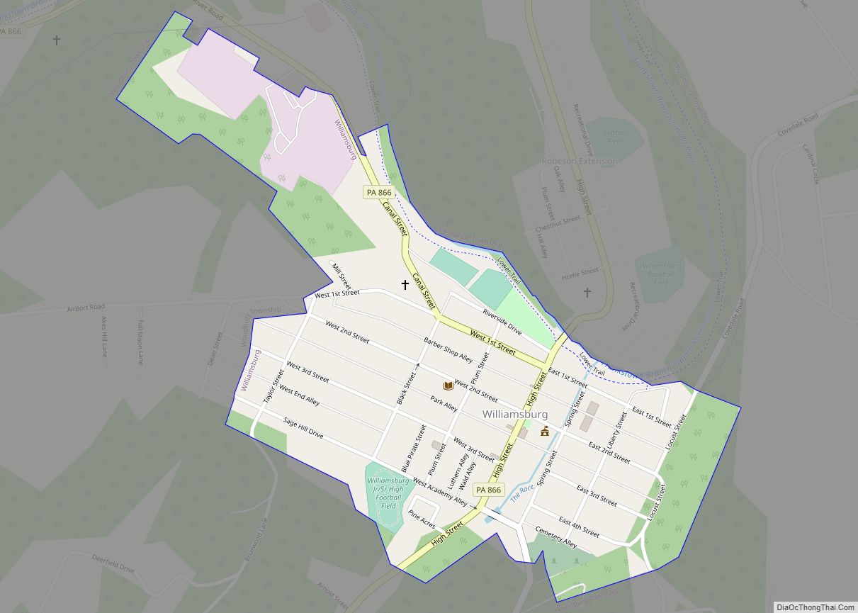
Williamsburg in Morrisons Cove, is a borough in Blair County, Pennsylvania, United States. The population was 1,241 at the 2020 census. It is part of the Altoona, PA Metropolitan Statistical Area. Williamsburg borough overview: Name: Williamsburg borough LSAD Code: 21 LSAD Description: borough (suffix) State: Pennsylvania County: Blair County Incorporated: 1827 Elevation: 846 ft (258 m) Total ... Read more
Map of Williamsburg borough, Pennsylvania
Map of Wolfdale CDP
Wolfdale is a census-designated place (CDP) in Washington County, Pennsylvania, United States. The population was 2,888 at the 2010 census. Wolfdale CDP overview: Name: Wolfdale CDP LSAD Code: 57 LSAD Description: CDP (suffix) State: Pennsylvania County: Washington County Total Area: 2.4 sq mi (6 km²) Population Density: 1,202.9/sq mi (464.4/km²) Area code: 724 FIPS code: 4286000 Online Interactive Map ... Read more
Map of Wolfdale CDP
Map of Witmer CDP
Witmer is an unincorporated community and census-designated place (CDP) in East Lampeter Township, Lancaster County, Pennsylvania, United States. As of the 2010 census, the population was 492. Witmer CDP overview: Name: Witmer CDP LSAD Code: 57 LSAD Description: CDP (suffix) State: Pennsylvania County: Lancaster County Elevation: 400 ft (100 m) Total Area: 1.24 sq mi (3.22 km²) Land Area: 1.24 sq mi ... Read more
Map of Witmer CDP
Map of Winterstown borough
Winterstown is a borough in York County, Pennsylvania, United States. The population was 609 at the time of the 2020 census. Winterstown borough overview: Name: Winterstown borough LSAD Code: 21 LSAD Description: borough (suffix) State: Pennsylvania County: York County Incorporated: 1871 Elevation: 807 ft (246 m) Total Area: 2.41 sq mi (6.25 km²) Land Area: 2.41 sq mi (6.25 km²) Water Area: 0.00 sq mi ... Read more
Map of Winterstown borough
Map of Winfield CDP, Pennsylvania
Winfield is a census-designated place located in Union Township, Union County in the state of Pennsylvania. The community is located in eastern Union County at the intersection of Pennsylvania Route 304 and U.S. Route 15, which is located along the shores of the West Branch Susquehanna River. As of the 2010 census the population was ... Read more
Map of Winfield CDP, Pennsylvania
Map of Windsor borough, Pennsylvania
Windsor is a borough in York County, Pennsylvania, United States. It was established in 1905 and was named after Windsor, England and was formerly named Windsorville. The population was 1,359 at the 2020 census. In the spring of 2016, the Pennsylvania Department of Conservation and Natural Resources and York County’s Marcellus Shale fund provided $350,000 ... Read more
Map of Windsor borough, Pennsylvania
Map of Windber borough
Windber is a borough in Somerset County, Pennsylvania, United States, which is located approximately three miles (4.8 km) south of Johnstown. At one time, it was a place of multiple industrial activities, including coal mining, lumbering, and the manufacture of fire brick. The community was founded in 1897 by coal barons Charles and Edward Julius Berwind, ... Read more
Map of Windber borough
Map of Wind Ridge CDP
Wind Ridge is an unincorporated community and census-designated place (CDP) in Richhill Township, Greene County, Pennsylvania, United States. It is located along Pennsylvania Route 21, 18 miles (29 km) west of Waynesburg, the Greene County seat, and 5 miles (8 km) east of the West Virginia border. As of the 2010 census, the population was 215. Wind ... Read more
Map of Wind Ridge CDP
Map of Wind Gap borough
Wind Gap (Pennsylvania Dutch: Gratdaal) is a borough in Northampton County, Pennsylvania. The population of Wind Gap was 2,820 at the 2020 census. Wind Gap is part of the Lehigh Valley metropolitan area, which had a population of 861,899 and was the 68th-most populous metropolitan area in the U.S. as of the 2020 census. Wind ... Read more
Map of Wind Gap borough
Map of Wilson borough, Pennsylvania
Wilson is a borough in Northampton County, Pennsylvania. The population was 8,259 at the 2020 census. Wilson is located adjacent to the city of Easton and is part of the Lehigh Valley metropolitan area, which had a population of 861,899 and was the 68th-most populous metropolitan area in the U.S. as of the 2020 census. ... Read more
Map of Wilson borough, Pennsylvania
Map of Wilmore borough, Pennsylvania
Wilmore is a borough in Cambria County, Pennsylvania, United States. It is part of the Johnstown, Pennsylvania Metropolitan Statistical Area. The population was 225 at the 2010 census. Wilmore borough overview: Name: Wilmore borough LSAD Code: 21 LSAD Description: borough (suffix) State: Pennsylvania County: Cambria County Incorporated: 1859 Elevation: 1,555 ft (474 m) Total Area: 0.33 sq mi (0.86 km²) ... Read more
Map of Wilmore borough, Pennsylvania