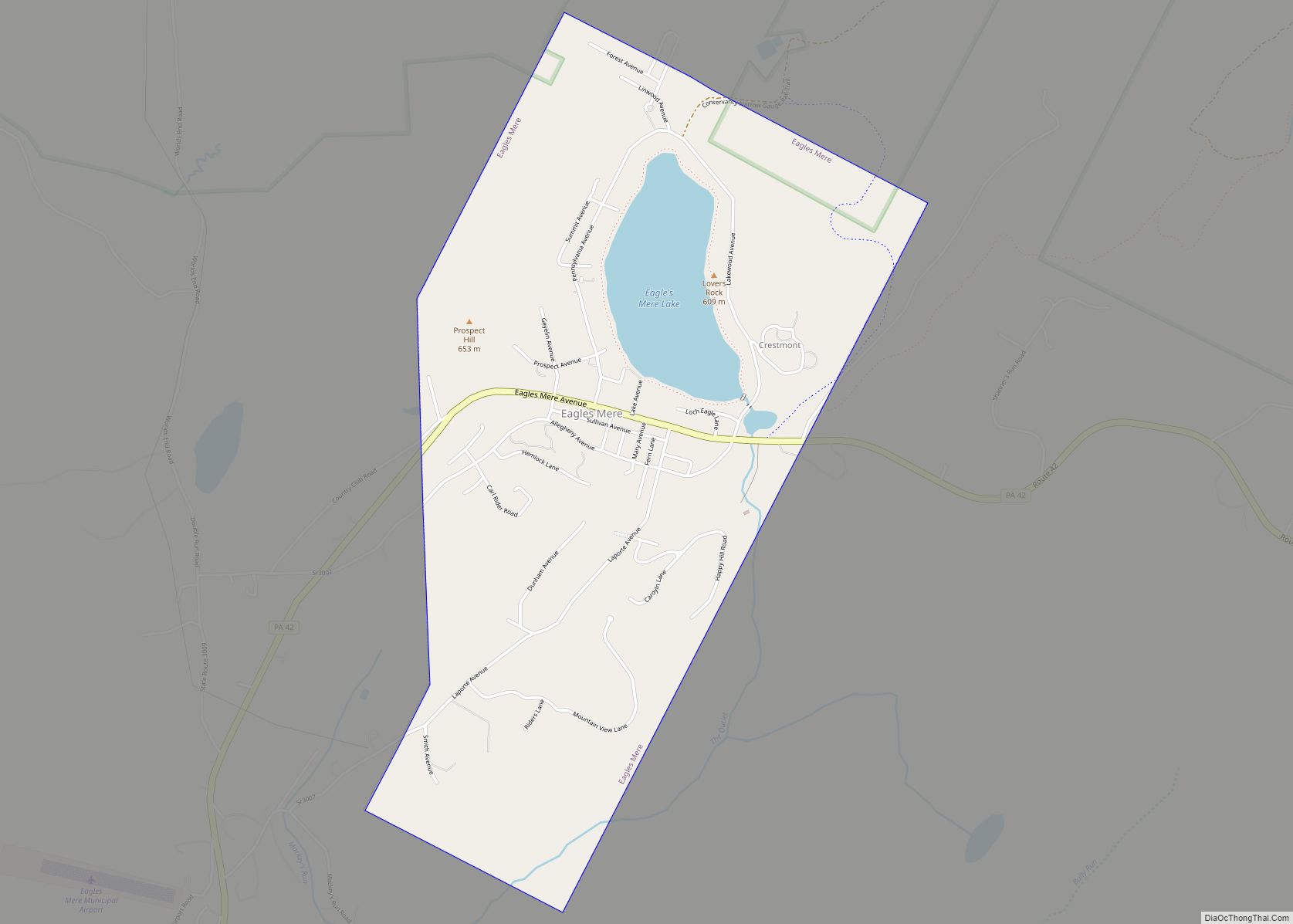
Map of Dushore borough
Dushore is a borough in Sullivan County, Pennsylvania, United States. The population was 450 at the 2020 census. Dushore is home to Sullivan County’s only traffic light. Dushore borough overview: Name: Dushore borough LSAD Code: 21 LSAD Description: borough (suffix) State: Pennsylvania County: Sullivan County Elevation: 1,450 ft (440 m) Total Area: 0.80 sq mi (2.08 km²) Land Area: 0.79 sq mi ... Read more
Map of Dushore borough
Map of Duryea borough
Duryea is a borough in the Greater Pittston area of Luzerne County, Pennsylvania, United States, 9 miles (14 km) south of Scranton. The Susquehanna River marks Duryea’s western boundary and the Lackawanna River flows through Duryea. It was incorporated as a borough in 1901, and had a notable switching rail yard, the Duryea yard (or Muller ... Read more
Map of Duryea borough
Map of Duquesne city, Pennsylvania
Duquesne (/djuːˈkeɪn/ dew-KAYN) is a city along the Monongahela River in Allegheny County, Pennsylvania, United States, within the Pittsburgh metropolitan area. The population was 5,254 at the 2020 census. Duquesne city overview: Name: Duquesne city LSAD Code: 25 LSAD Description: city (suffix) State: Pennsylvania County: Allegheny County Incorporated: September 12, 1891 (borough) Total Area: 2.01 sq mi ... Read more
Map of Duquesne city, Pennsylvania
Map of Dupont borough, Pennsylvania
Dupont is a borough in the Greater Pittston area of Luzerne County, Pennsylvania, United States. The population was 2,536 as of the 2020 census. Dupont borough overview: Name: Dupont borough LSAD Code: 21 LSAD Description: borough (suffix) State: Pennsylvania County: Luzerne County Incorporated: 1917 Elevation: 720 ft (220 m) Total Area: 1.56 sq mi (4.05 km²) Land Area: 1.56 sq mi (4.05 km²) ... Read more
Map of Dupont borough, Pennsylvania
Map of Dunnstown CDP
Dunnstown is a census-designated place (CDP) in Clinton County, Pennsylvania, United States. The population was 1,360 at the 2010 census. Dunnstown CDP overview: Name: Dunnstown CDP LSAD Code: 57 LSAD Description: CDP (suffix) State: Pennsylvania County: Clinton County Elevation: 657 ft (200 m) Total Area: 0.84 sq mi (2.17 km²) Land Area: 0.82 sq mi (2.13 km²) Water Area: 0.02 sq mi (0.04 km²) Total Population: ... Read more
Map of Dunnstown CDP
Map of Dunmore borough
Dunmore is a borough in Lackawanna County, Pennsylvania, United States, adjoining Scranton. It is part of Northeastern Pennsylvania and was settled in 1835 and incorporated in 1862. Extensive anthracite coal, brick, stone, and silk interests had led to a rapid increase in the population from 8,315 in 1890 to 23,086 in 1940. The population was ... Read more
Map of Dunmore borough
Map of Earlston CDP
Earlston is a census-designated place in West Providence Township, Bedford County, Pennsylvania, in the United States. The population was 1,122 as of the 2010 census. It is located just across the Raystown Branch of the Juniata River from the borough of Everett. Earlston CDP overview: Name: Earlston CDP LSAD Code: 57 LSAD Description: CDP (suffix) ... Read more
Map of Earlston CDP
Map of East Greenville borough
East Greenville is a borough in Montgomery County, Pennsylvania. The population was 2,951 at the 2010 census. It is one of a strip of small towns that run together along Route 29, including Red Hill, Pennsburg, and East Greenville. The borough is part of the Upper Perkiomen School District. East Greenville borough overview: Name: East ... Read more
Map of East Greenville borough
Map of East Freedom CDP
East Freedom is a census-designated place (CDP) in Freedom Township, Blair County, Pennsylvania, United States. It is located near I-99 and is approximately four miles to the west of the borough of Roaring Spring. As of the 2010 census, the population was 972 residents. East Freedom CDP overview: Name: East Freedom CDP LSAD Code: 57 ... Read more
Map of East Freedom CDP
Map of East Earl CDP
East Earl is an unincorporated community and census-designated place (CDP) in East Earl Township, Lancaster County, Pennsylvania, United States. As of the 2010 census, it had a population of 1,144. East Earl CDP overview: Name: East Earl CDP LSAD Code: 57 LSAD Description: CDP (suffix) State: Pennsylvania County: Lancaster County Elevation: 512 ft (156 m) Total Area: ... Read more
Map of East Earl CDP
Map of East Conemaugh borough
East Conemaugh is a borough in Cambria County, Pennsylvania, United States. It is part of the Johnstown, Pennsylvania Metropolitan Statistical Area. The population was 1,220 at the 2010 census. East Conemaugh borough overview: Name: East Conemaugh borough LSAD Code: 21 LSAD Description: borough (suffix) State: Pennsylvania County: Cambria County Incorporated: 1868 Elevation: 1,243 ft (379 m) Total ... Read more
Map of East Conemaugh borough
Map of East Butler borough
East Butler is a borough in Butler County, Pennsylvania, United States. The population was 732 at the 2010 census. East Butler borough overview: Name: East Butler borough LSAD Code: 21 LSAD Description: borough (suffix) State: Pennsylvania County: Butler County Total Area: 1.04 sq mi (2.70 km²) Land Area: 1.04 sq mi (2.70 km²) Water Area: 0.00 sq mi (0.00 km²) Total Population: 764 Population ... Read more
Map of East Butler borough