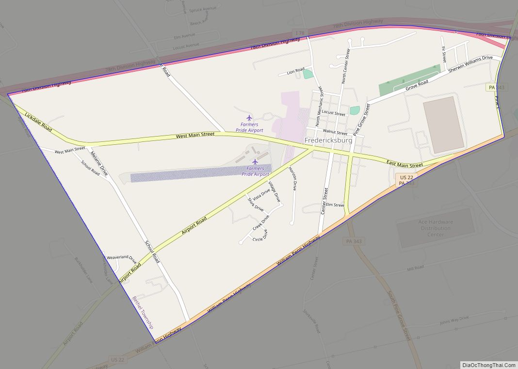
Map of Frankfort Springs borough
Frankfort Springs is a borough in southern Beaver County, Pennsylvania, United States. The population was 117 at the 2020 census. It is a part of the Pittsburgh metropolitan area. Frankfort Springs borough overview: Name: Frankfort Springs borough LSAD Code: 21 LSAD Description: borough (suffix) State: Pennsylvania County: Beaver County Incorporated: 1844 Elevation: 1,122 ft (342 m) Total ... Read more
Map of Frankfort Springs borough
Map of Frackville borough
Frackville is a borough in Schuylkill County, Pennsylvania, United States, incorporated in 1876. Today, the intersection of Interstate 81 and Pennsylvania State Route 61 is located near the borough, which is approximately 102 miles (164 km) northwest of Philadelphia and 60 miles (97 km) southwest of Scranton. Frackville is named for Daniel Frack, an early Anglo-American settler. ... Read more
Map of Frackville borough
Map of Friendsville borough, Pennsylvania
Friendsville is a borough in Susquehanna County, Pennsylvania, United States. The population was 100 at the 2020 census. Friendsville borough overview: Name: Friendsville borough LSAD Code: 21 LSAD Description: borough (suffix) State: Pennsylvania County: Susquehanna County Incorporated: 1847 Total Area: 1.50 sq mi (3.87 km²) Land Area: 1.50 sq mi (3.87 km²) Water Area: 0.00 sq mi (0.00 km²) Total Population: 101 Population Density: ... Read more
Map of Friendsville borough, Pennsylvania
Map of Friedensburg CDP
Friedensburg is a census-designated place (CDP) in Schuylkill County, Pennsylvania, United States. The population was 828 at the time of the 2000 census. Friedensburg CDP overview: Name: Friedensburg CDP LSAD Code: 57 LSAD Description: CDP (suffix) State: Pennsylvania County: Schuylkill County Total Area: 1.73 sq mi (4.49 km²) Land Area: 1.73 sq mi (4.49 km²) Water Area: 0.00 sq mi (0.00 km²) Total Population: ... Read more
Map of Friedensburg CDP
Map of Friedens CDP
Friedens is a census-designated place (CDP) that is part of Somerset Township in Somerset County, Pennsylvania, United States. The population was 1,523 at the 2010 census. It is part of the Johnstown, Pennsylvania Metropolitan Statistical Area. Friedens CDP overview: Name: Friedens CDP LSAD Code: 57 LSAD Description: CDP (suffix) State: Pennsylvania County: Somerset County Total ... Read more
Map of Friedens CDP
Map of Freeport borough, Pennsylvania
Freeport is a borough in Armstrong County, Pennsylvania, United States. It is situated along the Allegheny River in the southwestern corner of the county. The population was 1,736 at the 2020 census. Freeport borough overview: Name: Freeport borough LSAD Code: 21 LSAD Description: borough (suffix) State: Pennsylvania County: Armstrong County Incorporated: 1833 Elevation: 790 ft (240 m) ... Read more
Map of Freeport borough, Pennsylvania
Map of Freemansburg borough
Freemansburg is a borough in Northampton County, Pennsylvania. The population of Freemansburg was 2,875 as of the 2020 census. The Lehigh River, a 109-mile-long (175 km) tributary of the Delaware River, flows through Freemansburg. Freemansburg is part of the Lehigh Valley metropolitan area, which had a population of 861,899 and was the 68th-most populous metropolitan area ... Read more
Map of Freemansburg borough
Map of Freeland borough, Pennsylvania
Freeland is a borough in Luzerne County, Pennsylvania, United States. It was originally called Birbeckville, South Heberton, and Freehold. Freeland is 18 miles (29 km) south of Wilkes-Barre and 10 miles (16 km) northeast of Hazleton. It was incorporated as a borough on September 11, 1876. Coal mining was the chief industry in the community through the ... Read more
Map of Freeland borough, Pennsylvania
Map of Freedom borough, Pennsylvania
Freedom is a borough in Beaver County, Pennsylvania, United States, located along the Ohio River 25 miles (40 km) northwest of Pittsburgh. The population was 1,495 at the 2020 census. It is a northern suburb of the Pittsburgh metropolitan area. Originally founded as a steamboat building town, chief industries later included the production of oil, caskets, ... Read more
Map of Freedom borough, Pennsylvania
Map of Freeburg borough, Pennsylvania
Freeburg is a borough in Snyder County, Pennsylvania, United States. The population was 557 at the 2020 census. Freeburg borough overview: Name: Freeburg borough LSAD Code: 21 LSAD Description: borough (suffix) State: Pennsylvania County: Snyder County Total Area: 0.32 sq mi (0.83 km²) Land Area: 0.32 sq mi (0.83 km²) Water Area: 0.00 sq mi (0.00 km²) Total Population: 557 Population Density: 1,746.08/sq mi (674.44/km²) ... Read more
Map of Freeburg borough, Pennsylvania
Map of Fredonia borough, Pennsylvania
Fredonia is a borough in central Mercer County, Pennsylvania, United States. The population was 435 at the 2020 census. It is part of the Youngstown–Warren metropolitan area. Fredonia borough overview: Name: Fredonia borough LSAD Code: 21 LSAD Description: borough (suffix) State: Pennsylvania County: Mercer County Total Area: 0.36 sq mi (0.92 km²) Land Area: 0.36 sq mi (0.92 km²) Water Area: ... Read more
Map of Fredonia borough, Pennsylvania
Map of Frizzleburg CDP
Frizzleburg is an unincorporated community and census-designated place (CDP) in Lawrence County, Pennsylvania, United States. The population was 602 at the 2010 census. Frizzleburg CDP overview: Name: Frizzleburg CDP LSAD Code: 57 LSAD Description: CDP (suffix) State: Pennsylvania County: Lawrence County Elevation: 1,078 ft (329 m) Total Area: 2.84 sq mi (7.34 km²) Land Area: 2.82 sq mi (7.31 km²) Water Area: 0.01 sq mi ... Read more
Map of Frizzleburg CDP