Map of Arlington Heights CDP, Pennsylvania

Map of Arlington Heights CDP, Pennsylvania

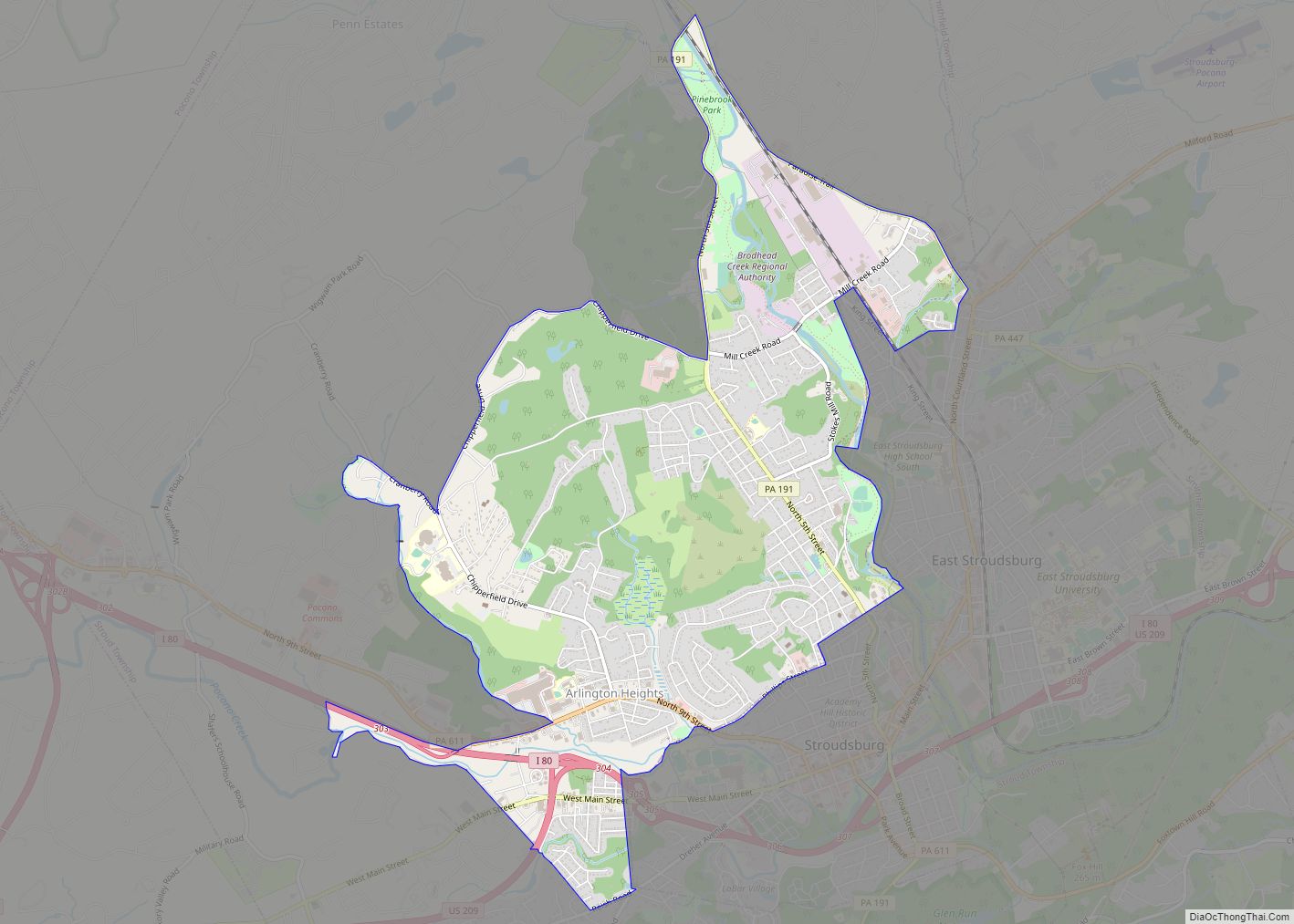
Arlington Heights is a census-designated place (CDP) in Monroe County, Pennsylvania, United States. The population was 6,331 at the 2020 census. One notable location in Arlington Heights is the Stroud Mall. Arlington Heights is 38.7 miles (62.3 km) northeast of Allentown and 76.7 miles (123.4 km) northwest of New York City. Arlington Heights CDP overview: Name: Arlington … Read more

Map of Aristes CDP

Map of Aristes CDP

Aristes is a census-designated place (CDP) in Conyngham Township, Columbia County, Pennsylvania, United States. It is part of Northeastern Pennsylvania. The population was 311 at the 2010 census. It is part of the Bloomsburg-Berwick micropolitan area. Aristes is located adjacent to the famous “ghost town” of Centralia. Aristes CDP overview: Name: Aristes CDP LSAD Code: … Read more

Map of Arendtsville borough

Map of Arendtsville borough

Arendtsville is a borough in Adams County, Pennsylvania, United States. The borough lies on Pennsylvania Route 234 and is well known for its annual Apple Harvest Festival in the fall. The population was 867 at the 2020 census. Arendtsville borough overview: Name: Arendtsville borough LSAD Code: 21 LSAD Description: borough (suffix) State: Pennsylvania County: Adams … Read more

Map of Ardmore CDP, Pennsylvania

Map of Ardmore CDP, Pennsylvania

Ardmore is an unincorporated community and census-designated place (CDP) spanning the border between Delaware and Montgomery counties in the U.S. state of Pennsylvania. The population was 12,455 at the time of the 2010 census and had risen to 13,566 in the 2020 census. Ardmore is a suburb on the west side of Philadelphia within Lower … Read more

Map of Atglen borough

Map of Atglen borough

Atglen is a borough in Chester County, Pennsylvania, United States. According to the 2020 census, its population is 1,311. Atglen borough overview: Name: Atglen borough LSAD Code: 21 LSAD Description: borough (suffix) State: Pennsylvania County: Chester County Elevation: 489 ft (149 m) Total Area: 0.88 sq mi (2.28 km²) Land Area: 0.88 sq mi (2.27 km²) Water Area: 0.01 sq mi (0.02 km²) Total Population: 1,313 … Read more

Map of Aspinwall borough, Pennsylvania

Map of Aspinwall borough, Pennsylvania

Aspinwall is a borough on the Allegheny River in Allegheny County, Pennsylvania, United States. It is part of the Greater Pittsburgh metropolitan area. In 1900, 1,231 people lived in Aspinwall, and that number rose to 2,592 in 1910, and 3,170 by 1920. The population was 2,916 at the 2020 census. Aspinwall borough overview: Name: Aspinwall … Read more

Map of Aspers CDP

Map of Aspers CDP

Aspers is a census-designated place in Adams County, Pennsylvania, United States. As of the 2020 census, it had a population of 486. At the 2000 census it was listed as the Bendersville Station-Aspers CDP. Aspers CDP overview: Name: Aspers CDP LSAD Code: 57 LSAD Description: CDP (suffix) State: Pennsylvania County: Adams County Total Area: 0.92 sq mi … Read more

Map of Ashville borough, Pennsylvania

Map of Ashville borough, Pennsylvania

Ashville is a borough in Cambria County, Pennsylvania, United States. It is part of the Johnstown, Pennsylvania Metropolitan Statistical Area. However, it is much closer to Altoona and is often considered a suburb of the latter. The population was 213 at the 2020 census. Ashville borough overview: Name: Ashville borough LSAD Code: 21 LSAD Description: … Read more

Map of Ashley borough, Pennsylvania

Map of Ashley borough, Pennsylvania

Ashley is a borough in Luzerne County, Pennsylvania, one mile (2 km) from Wilkes Barre. The population was 2,588 at the 2020 census. Ashley borough overview: Name: Ashley borough LSAD Code: 21 LSAD Description: borough (suffix) State: Pennsylvania County: Luzerne County Elevation: 627 ft (191 m) Total Area: 0.93 sq mi (2.42 km²) Land Area: 0.93 sq mi (2.42 km²) Water Area: 0.00 sq mi (0.00 km²) … Read more

Map of Atlasburg CDP

Map of Atlasburg CDP

Atlasburg is a census-designated place located in Smith Township, Washington County in the state of Pennsylvania. The community is located in northern Washington County along Pennsylvania Route 18 about 5 miles south of the borough of Burgettstown. As of the 2010 census the population was 401 residents. Atlasburg CDP overview: Name: Atlasburg CDP LSAD Code: … Read more

Map of Atlas CDP

Map of Atlas CDP

Atlas is a census-designated place located in Mount Carmel Township, Northumberland County in the state of Pennsylvania. The community is located very close to the borough of Mount Carmel along Pennsylvania Route 61. As of the 2010 census the population was 809 residents. Atlas CDP overview: Name: Atlas CDP LSAD Code: 57 LSAD Description: CDP … Read more

Map of Atlantic CDP, Pennsylvania

Map of Atlantic CDP, Pennsylvania

Atlantic is a census-designated place (CDP) in Crawford County, Pennsylvania, United States. The population was 77 at the 2010 census, up from 43 in 2000. Atlantic CDP overview: Name: Atlantic CDP LSAD Code: 57 LSAD Description: CDP (suffix) State: Pennsylvania County: Crawford County Elevation: 1,147 ft (350 m) Total Area: 0.16 sq mi (0.41 km²) Land Area: 0.16 sq mi (0.41 km²) Water … Read more