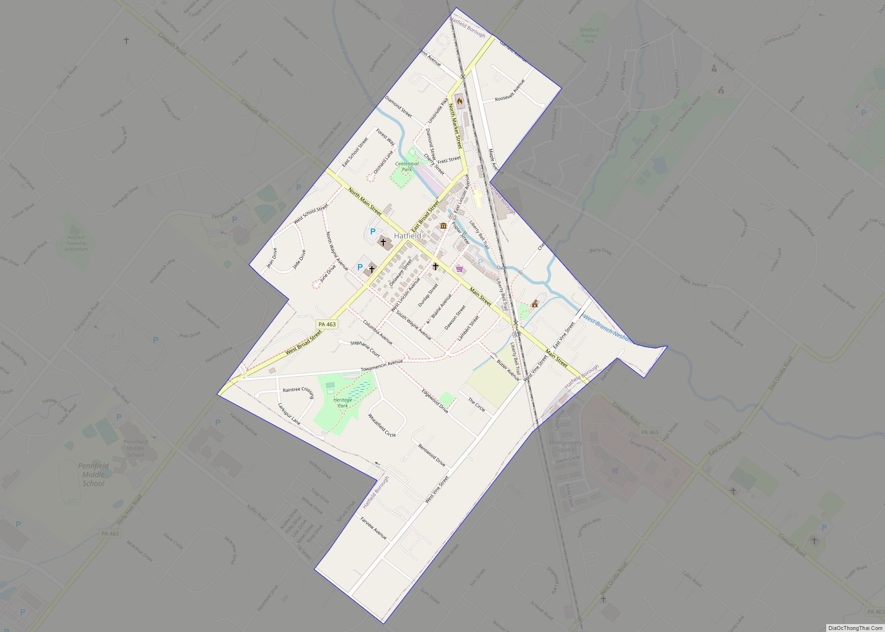
Map of Hasson Heights CDP
Hasson Heights is a census-designated place (CDP) in Venango County, Pennsylvania, United States. The population was 1,351 at the 2010 census. Hasson Heights CDP overview: Name: Hasson Heights CDP LSAD Code: 57 LSAD Description: CDP (suffix) State: Pennsylvania County: Venango County FIPS code: 4233072 Online Interactive Map Hasson Heights online map. Source: Basemap layers from ... Read more
Map of Hasson Heights CDP
Map of Harwick CDP
Harwick is a town within Springdale Township in Allegheny County, Pennsylvania, United States. As of the 2020 census, it had a population of 850. Harwick CDP overview: Name: Harwick CDP LSAD Code: 57 LSAD Description: CDP (suffix) State: Pennsylvania County: Allegheny County Total Area: 0.44 sq mi (1.14 km²) Land Area: 0.44 sq mi (1.14 km²) Water Area: 0.00 sq mi (0.00 km²) Total ... Read more
Map of Harwick CDP
Map of Harveys Lake borough
Harveys Lake is a borough in Luzerne County, Pennsylvania, United States. It is part of the Back Mountain, a one hundred and eighteen-square mile region in northern Luzerne County. The borough is named after the lake, its principal feature, which in turn was named after Benjamin Harvey, a local settler. Harvey was a member of ... Read more
Map of Harveys Lake borough
Map of Hartstown CDP
Hartstown is a census-designated place (CDP) in Crawford County, Pennsylvania, United States. The population was 201 at the 2010 census, down from 246 in 2000. Hartstown CDP overview: Name: Hartstown CDP LSAD Code: 57 LSAD Description: CDP (suffix) State: Pennsylvania County: Crawford County Elevation: 1,040 ft (320 m) Total Area: 0.84 sq mi (2.17 km²) Land Area: 0.82 sq mi (2.12 km²) Water ... Read more
Map of Hartstown CDP
Map of Hawley borough, Pennsylvania
Hawley is a borough on the Lackawaxen River in Wayne County, Pennsylvania, United States. The borough’s population was 1,229 at the time of the 2020 United States Census. Hawley borough overview: Name: Hawley borough LSAD Code: 21 LSAD Description: borough (suffix) State: Pennsylvania County: Wayne County Elevation: 1,033 ft (315 m) Total Area: 0.62 sq mi (1.60 km²) Land Area: ... Read more
Map of Hawley borough, Pennsylvania
Map of Hawk Run CDP
Hawk Run is a census-designated place located in Morris Township, Clearfield County, in the state of Pennsylvania. As of the 2020 census the population was 474. It is located on the north side of Moshannon Creek, the Clearfield/Centre County boundary, approximately 3 miles (5 km) north of Philipsburg via Pennsylvania Route 53. Hawk Run CDP overview: ... Read more
Map of Hawk Run CDP
Map of Hellertown borough
Hellertown is a borough in Northampton County, Pennsylvania. Its population was 6,131 at the 2020 census. Hellertown is part of the Lehigh Valley metropolitan area, which had a population of 861,899 and was the 68th-most populous metropolitan area in the U.S. as of 2020. Hellertown is home to Lost River Caverns, a natural limestone cavern. ... Read more
Map of Hellertown borough
Map of Heilwood CDP
Heilwood is a census-designated place (CDP) in Indiana County, Pennsylvania, United States. The population was 711 at the time of the 2010 census. Heilwood CDP overview: Name: Heilwood CDP LSAD Code: 57 LSAD Description: CDP (suffix) State: Pennsylvania County: Indiana County Total Area: 1.25 sq mi (3.25 km²) Land Area: 1.25 sq mi (3.25 km²) Water Area: 0.00 sq mi (0.00 km²) Total Population: ... Read more
Map of Heilwood CDP
Map of Heidlersburg CDP
Heidlersburg is an unincorporated community and census-designated place in Tyrone Township, Adams County, Pennsylvania, United States. As of the 2020 census, the population was 509. Heidlersburg is located at the crossroads of Pennsylvania Route 234 and Old Harrisburg Road, the former U.S. Route 15. Route 15 now bypasses the town to the east, with access ... Read more
Map of Heidlersburg CDP
Map of Heidelberg borough, Pennsylvania
Heidelberg is a borough located southwest of Pittsburgh in Allegheny County, Pennsylvania, United States. The population was 1,288 at the 2020 census. The borough was named after Heidelberg in Germany, the native home of a large share of the early settlers. Heidelberg borough overview: Name: Heidelberg borough LSAD Code: 21 LSAD Description: borough (suffix) State: ... Read more
Map of Heidelberg borough, Pennsylvania
Map of Hegins CDP
Hegins (pronounced Higgins) is a census-designated place located in Hegins Township, Schuylkill County in the state of Pennsylvania, United States. The community is located near the community of Valley View at the intersection of Pennsylvania Routes 25 and 125 and is approximately 50 miles northeast of Harrisburg. As of the 2018 the population was 850 ... Read more
Map of Hegins CDP
Map of Heckscherville CDP
Heckscherville is a census-designated place (CDP) in Schuylkill County, Pennsylvania, United States. The population was 220 at the 2010 census. Heckscherville CDP overview: Name: Heckscherville CDP LSAD Code: 57 LSAD Description: CDP (suffix) State: Pennsylvania County: Schuylkill County Total Area: 0.33 sq mi (0.86 km²) Land Area: 0.33 sq mi (0.86 km²) Water Area: 0.00 sq mi (0.00 km²) Total Population: 196 Population Density: ... Read more
Map of Heckscherville CDP