Map of Manns Choice borough
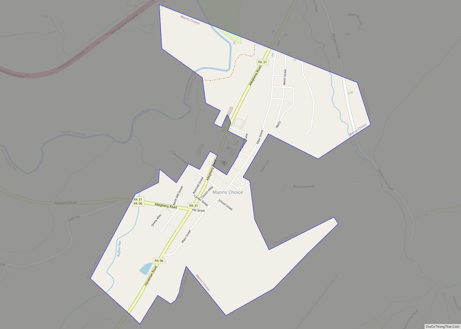
Manns Choice is a borough in Bedford County, Pennsylvania, United States. The population was 313 at the 2020 census. Manns Choice borough overview: Name: Manns Choice borough LSAD Code: 21 LSAD Description: borough (suffix) State: Pennsylvania County: Bedford County Incorporated: 1886 Elevation: 1,460 ft (450 m) Total Area: 0.51 sq mi (1.31 km²) Land Area: 0.50 sq mi (1.30 km²) Water Area: 0.01 sq mi ... Read more
Map of Manns Choice borough
Map of Manheim borough
Manheim is a borough in Lancaster County, Pennsylvania, United States. The population was 5,064 at the 2020 census. The borough was named after Kerpen-Manheim, Germany. Manheim borough overview: Name: Manheim borough LSAD Code: 21 LSAD Description: borough (suffix) State: Pennsylvania County: Lancaster County Elevation: 407 ft (124 m) Total Area: 1.40 sq mi (3.63 km²) Land Area: 1.38 sq mi (3.58 km²) Water ... Read more
Map of Manheim borough
Map of Manchester borough, Pennsylvania
Manchester is a borough in York County, Pennsylvania, United States. The population was 2,798 at the 2020 census. Manchester borough overview: Name: Manchester borough LSAD Code: 21 LSAD Description: borough (suffix) State: Pennsylvania County: York County Incorporated: 1869 Elevation: 453 ft (138 m) Total Area: 0.77 sq mi (2.00 km²) Land Area: 0.77 sq mi (2.00 km²) Water Area: 0.00 sq mi (0.00 km²) Total Population: ... Read more
Map of Manchester borough, Pennsylvania
Map of Mammoth CDP, Pennsylvania
Mammoth is a census-designated place that is located in Mount Pleasant Township, Westmoreland County in the state of Pennsylvania, United States, with its own post office and postal zip code: 15664. The community is located just off Pennsylvania Route 982 and is part of the Mount Pleasant Area School District. Mammoth CDP overview: Name: Mammoth ... Read more
Map of Mammoth CDP, Pennsylvania
Map of Malvern borough, Pennsylvania
Malvern is a borough in Chester County, Pennsylvania, United States. It is twenty-five miles (40 km) west of Philadelphia. The population was 3,419 at the 2020 census. Malvern borough overview: Name: Malvern borough LSAD Code: 21 LSAD Description: borough (suffix) State: Pennsylvania County: Chester County Incorporated: 1889 Elevation: 551 ft (168 m) Total Area: 1.27 sq mi (3.28 km²) Land Area: ... Read more
Map of Malvern borough, Pennsylvania
Map of Maitland CDP, Pennsylvania
Maitland is a census-designated place in Derry Township, Mifflin County, Pennsylvania, United States, just outside the borough of Lewistown. At the 2010 census, the population was 357. Maitland CDP overview: Name: Maitland CDP LSAD Code: 57 LSAD Description: CDP (suffix) State: Pennsylvania County: Mifflin County Elevation: 712 ft (217 m) Total Area: 1.44 sq mi (3.73 km²) Land Area: 1.44 sq mi ... Read more
Map of Maitland CDP, Pennsylvania
Map of Marion CDP, Pennsylvania
Marion is an unincorporated community and census-designated place (CDP) in Franklin County, Pennsylvania, United States. As of the 2020 census, the population was 851. It lies along U.S. Route 11, 6 miles (10 km) south of Chambersburg and 5 miles (8 km) north of Greencastle. Interstate 81 passes along the eastern edge of the community, with access ... Read more
Map of Marion CDP, Pennsylvania
Map of Marion Heights borough
Marion Heights is a borough in Northumberland County, Pennsylvania, United States. The population was 611 at the 2010 census. Marion Heights borough overview: Name: Marion Heights borough LSAD Code: 21 LSAD Description: borough (suffix) State: Pennsylvania County: Northumberland County Incorporated: 1906 Total Area: 0.15 sq mi (0.40 km²) Land Area: 0.15 sq mi (0.40 km²) Water Area: 0.00 sq mi (0.00 km²) Total Population: ... Read more
Map of Marion Heights borough
Map of Marion Center borough, Pennsylvania
Marion Center is a borough in Indiana County, Pennsylvania, United States. The population was 413 at the 2020 census. Marion Center borough overview: Name: Marion Center borough LSAD Code: 21 LSAD Description: borough (suffix) State: Pennsylvania County: Indiana County Incorporated: 1869 Elevation: 1,283 ft (391 m) Total Area: 0.74 sq mi (1.92 km²) Land Area: 0.74 sq mi (1.92 km²) Water Area: 0.00 sq mi ... Read more
Map of Marion Center borough, Pennsylvania
Map of Marietta borough, Pennsylvania
Marietta is a borough in Lancaster County, Pennsylvania, United States. The population was 2,633 at the 2020 census. It is located on the east bank of the Susquehanna River, northwest of Columbia. Marietta borough overview: Name: Marietta borough LSAD Code: 21 LSAD Description: borough (suffix) State: Pennsylvania County: Lancaster County Elevation: 279 ft (85 m) Total Area: ... Read more
Map of Marietta borough, Pennsylvania
Map of Marienville CDP
Marienville is an unincorporated community and census-designated place (CDP) in Jenks Township, Forest County, Pennsylvania, United States. Its altitude is 1,735 feet (529 m), and it is located at 41°28′12″N 79°7′29″W / 41.47000°N 79.12472°W / 41.47000; -79.12472 (41.4702014, -79.1247623). Other names for the community have included “Marion” and “Marionville”. Marienville is a major point on a ... Read more
Map of Marienville CDP
Map of Marianne CDP
Marianne is a census-designated place located in Paint Township and Elk Township, Clarion County, in the U.S. state of Pennsylvania. The community is located at the intersections of Pennsylvania Route 66 and U.S. Route 322, approximately 1 mile (1.6 km) east of the borough of Shippenville and 3 miles (5 km) northwest of Clarion, the county seat. ... Read more
Map of Marianne CDP