Map of Oakwood CDP, Pennsylvania
Oakwood is an unincorporated area and census-designated place (CDP) in Lawrence County, Pennsylvania, United States. The population was 2,270 at the 2010 census. Oakwood CDP overview: Name: Oakwood CDP LSAD Code: 57 LSAD Description: CDP (suffix) State: Pennsylvania County: Lawrence County Elevation: 1,025 ft (312 m) Total Area: 2.64 sq mi (6.84 km²) Land Area: 2.59 sq mi (6.70 km²) Water Area: 0.05 sq mi ... Read more
Map of Oakwood CDP, Pennsylvania
Map of Oakmont borough
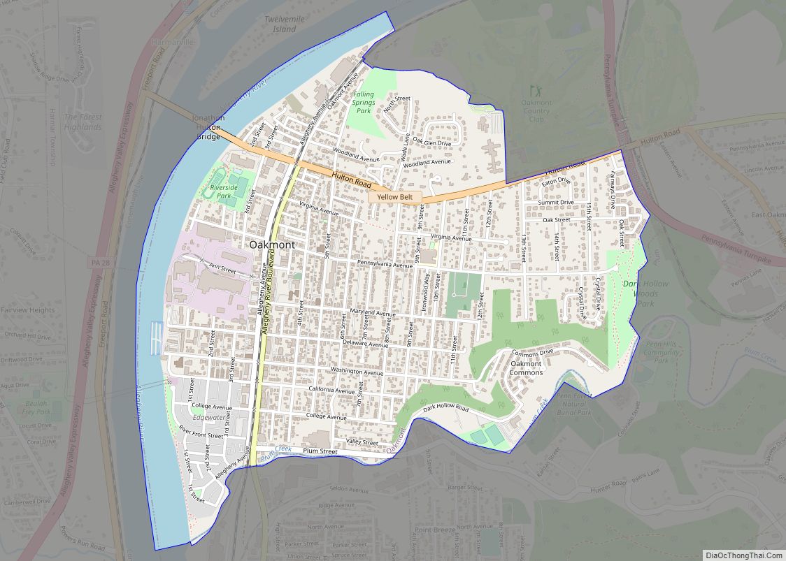
Oakmont is a borough in Allegheny County, in the U.S. state of Pennsylvania. It is a Pittsburgh suburb and part of the Pittsburgh Metro Area. The population was 6,758 as of the 2020 Census. Incorporated as a town in 1889, this Allegheny River community began in 1816 when a farmer, Michael Bright, bought a large ... Read more
Map of Oakmont borough
Map of Oakland CDP, Pennsylvania
Oakland is a census-designated place (CDP) in Stonycreek Township, Cambria County, Pennsylvania, United States. It is bordered on the west by the city of Johnstown and on the south by the boroughs of Lorain and Geistown. As of the 2010 census, the population of Oakland was 1,578. Oakland CDP overview: Name: Oakland CDP LSAD Code: ... Read more
Map of Oakland CDP, Pennsylvania
Map of Oakdale borough, Pennsylvania
Oakdale is a borough in Allegheny County, Pennsylvania, United States and is a Pittsburgh suburb. The population was 1,475 at the 2020 census. Its zip code is 15071. Oakdale borough overview: Name: Oakdale borough LSAD Code: 21 LSAD Description: borough (suffix) State: Pennsylvania County: Allegheny County Total Area: 0.47 sq mi (1.22 km²) Land Area: 0.47 sq mi (1.22 km²) Water ... Read more
Map of Oakdale borough, Pennsylvania
Map of Oak Hills CDP, Pennsylvania
Oak Hills is a census-designated place (CDP) in Butler County, Pennsylvania, United States. The population was 2,333 at the 2010 census. Oak Hills CDP overview: Name: Oak Hills CDP LSAD Code: 57 LSAD Description: CDP (suffix) State: Pennsylvania County: Butler County Elevation: 1,230 ft (370 m) Total Area: 3.37 sq mi (8.72 km²) Land Area: 3.37 sq mi (8.72 km²) Water Area: 0.00 sq mi ... Read more
Map of Oak Hills CDP, Pennsylvania
Map of Nuremberg CDP
Nuremberg is a census-designated place (CDP) that is located in Schuylkill and Luzerne counties, Pennsylvania, United States. The population was 434 at the time of the 2010 census. Nuremberg CDP overview: Name: Nuremberg CDP LSAD Code: 57 LSAD Description: CDP (suffix) State: Pennsylvania County: Luzerne County, Schuylkill County Total Area: 0.60 sq mi (1.55 km²) Land Area: 0.60 sq mi ... Read more
Map of Nuremberg CDP
Map of Numidia CDP
Numidia is a census-designated place (CDP) in Columbia County, Pennsylvania, United States. It is part of Northeastern Pennsylvania. The population was 244 at the 2010 census. It is part of the Bloomsburg-Berwick metropolitan area. Numidia CDP overview: Name: Numidia CDP LSAD Code: 57 LSAD Description: CDP (suffix) State: Pennsylvania County: Columbia County Elevation: 987 ft (301 m) ... Read more
Map of Numidia CDP
Map of Nuangola borough
Nuangola is a borough in Luzerne County, Pennsylvania. The population was 663 as of the 2020 census. Developed as a summer resort in the early 20th century, the borough is built around a heart-shaped lake called Nuangola Lake. Nuangola borough overview: Name: Nuangola borough LSAD Code: 21 LSAD Description: borough (suffix) State: Pennsylvania County: Luzerne ... Read more
Map of Nuangola borough
Map of Oley CDP
Oley (also called Friedensburg) is a census-designated place (CDP) that is located on Routes 73 and 662 in northern Oley Township, Berks County, United States. The ZIP code is 19547. Oley CDP overview: Name: Oley CDP LSAD Code: 57 LSAD Description: CDP (suffix) State: Pennsylvania County: Berks County Elevation: 443 ft (135 m) Total Area: 1.24 sq mi (3.22 km²) ... Read more
Map of Oley CDP
Map of Old Orchard CDP
Old Orchard is a census-designated place (CDP) in Palmer Township in Northampton County, Pennsylvania. As of the 2010 census, Old Orchard had a total population of 2,434. Old Orchard is part of the Lehigh Valley, which had a population of 861,899 and was the 68th-most populous metropolitan area in the U.S. as of the 2020 ... Read more
Map of Old Orchard CDP
Map of Old Forge borough, Pennsylvania
Old Forge is a borough in Lackawanna County, Pennsylvania, United States. The population was 8,524 at the 2020 census. It is located 5 miles (8 km) southwest of downtown Scranton and 12 miles (19 km) northeast of Wilkes-Barre. Old Forge borough overview: Name: Old Forge borough LSAD Code: 21 LSAD Description: borough (suffix) State: Pennsylvania County: Lackawanna ... Read more
Map of Old Forge borough, Pennsylvania
Map of Oklahoma CDP
Oklahoma is a census-designated place located in Sandy Township, Clearfield County, in the state of Pennsylvania. As of the 2020 census the population was 759. It is bordered to the northwest by the city of DuBois. Oklahoma CDP overview: Name: Oklahoma CDP LSAD Code: 57 LSAD Description: CDP (suffix) State: Pennsylvania County: Clearfield County Elevation: ... Read more
Map of Oklahoma CDP