Map of Fort Mill town
Fort Mill, also known as Fort Mill Township, is a town in York County, South Carolina, United States. It is a suburb of Charlotte, North Carolina. As of 2020 census, the population of the town was 24,521. Some businesses and residents in the Indian Land community of neighboring Lancaster County share a Fort Mill mailing ... Read more
Map of Fort Mill town
Map of Fort Lawn town
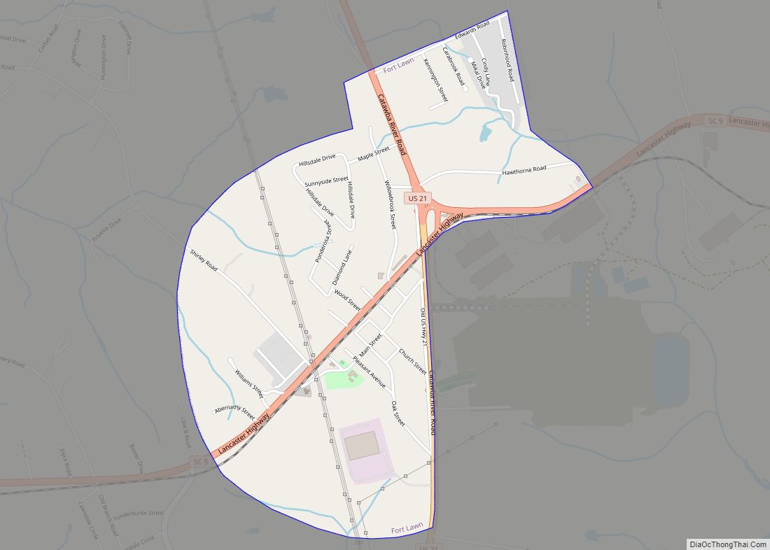
Fort Lawn is a town in Chester County, South Carolina. The population was 895 at the 2010 census. Fort Lawn town overview: Name: Fort Lawn town LSAD Code: 43 LSAD Description: town (suffix) State: South Carolina County: Chester County Incorporated: 1887 Elevation: 532 ft (162 m) Total Area: 1.39 sq mi (3.61 km²) Land Area: 1.39 sq mi (3.61 km²) Water Area: 0.00 sq mi ... Read more
Map of Fort Lawn town
Map of Forestbrook CDP
Forestbrook is a census-designated place (CDP) in Horry County, South Carolina, United States. The population was 4,612 at the 2010 census, up from 3,391 at the 2000 census. Forestbrook CDP overview: Name: Forestbrook CDP LSAD Code: 57 LSAD Description: CDP (suffix) State: South Carolina County: Horry County Elevation: 16 ft (5 m) Total Area: 3.67 sq mi (9.51 km²) Land ... Read more
Map of Forestbrook CDP
Map of Gaston town, South Carolina
Gaston is a town in Lexington County, South Carolina, United States. The population was 1,645 at the 2010 census. It is part of the Columbia, South Carolina Metropolitan Statistical Area. Gaston town overview: Name: Gaston town LSAD Code: 43 LSAD Description: town (suffix) State: South Carolina County: Lexington County Elevation: 499 ft (152 m) Total Area: 5.32 sq mi ... Read more
Map of Gaston town, South Carolina
Map of Garden City CDP, South Carolina
Garden City, sometimes known as Garden City Beach, is a census-designated place (CDP) in Horry County, South Carolina, United States. The population was 9,209 at the 2010 census. Garden City Beach is located directly south of Surfside Beach. The developed part of the beach extends south beyond the limits of the Garden City CDP, into ... Read more
Map of Garden City CDP, South Carolina
Map of Gramling CDP
Gramling is a census-designated place located in Spartanburg County in the U.S. state of South Carolina. According to the 2010 United States Census, the population was 86. Gramling CDP overview: Name: Gramling CDP LSAD Code: 57 LSAD Description: CDP (suffix) State: South Carolina County: Spartanburg County Elevation: 984 ft (300 m) Total Area: 1.01 sq mi (2.62 km²) Land Area: ... Read more
Map of Gramling CDP
Map of Govan town
Govan is a town in Bamberg County, South Carolina, United States. The population was 65 at the 2010 census. Govan town overview: Name: Govan town LSAD Code: 43 LSAD Description: town (suffix) State: South Carolina County: Bamberg County Elevation: 240 ft (70 m) Total Area: 0.75 sq mi (1.95 km²) Land Area: 0.75 sq mi (1.95 km²) Water Area: 0.00 sq mi (0.00 km²) Total Population: ... Read more
Map of Govan town
Map of Goose Creek city, South Carolina
Goose Creek is the largest city in Berkeley County in the U.S. state of South Carolina. The population was 45,946 at the 2020 census. Most of the Naval Weapons Station Charleston is in Goose Creek. As defined by the U.S. Office of Management and Budget, and used only by the U.S. Census Bureau and other ... Read more
Map of Goose Creek city, South Carolina
Map of Golden Grove CDP
Golden Grove is a census-designated place (CDP) in Greenville County, South Carolina, United States. The population was 2,467 at the 2010 census. It is part of the Greenville–Mauldin–Easley Metropolitan Statistical Area. Golden Grove CDP overview: Name: Golden Grove CDP LSAD Code: 57 LSAD Description: CDP (suffix) State: South Carolina County: Greenville County Elevation: 866 ft (264 m) ... Read more
Map of Golden Grove CDP
Map of Gloverville CDP
Gloverville is a census-designated place (CDP) in Aiken County, South Carolina, United States. The population was 2,831 at the 2010 census. It is part of the Augusta, Georgia metropolitan area. Gloverville is located in historic Horse Creek Valley. Gloverville CDP overview: Name: Gloverville CDP LSAD Code: 57 LSAD Description: CDP (suffix) State: South Carolina County: ... Read more
Map of Gloverville CDP
Map of Glendale CDP, South Carolina
Glendale is a census-designated place located in Spartanburg County in the U.S. State of South Carolina. According to the 2010 United States Census, the population was 307. Glendale CDP overview: Name: Glendale CDP LSAD Code: 57 LSAD Description: CDP (suffix) State: South Carolina County: Spartanburg County Elevation: 699 ft (213 m) Total Area: 0.21 sq mi (0.55 km²) Land Area: ... Read more
Map of Glendale CDP, South Carolina
Map of Gilbert town, South Carolina
Gilbert is a town in Lexington County, South Carolina, United States. The population was 569 at the 2010 census. It is part of the Columbia, South Carolina Metropolitan Statistical Area. Gilbert town overview: Name: Gilbert town LSAD Code: 43 LSAD Description: town (suffix) State: South Carolina County: Lexington County Elevation: 541 ft (165 m) Total Area: 2.77 sq mi ... Read more
Map of Gilbert town, South Carolina