Map of Ravenel town

Map of Ravenel town

Ravenel is a town in Charleston County, South Carolina, United States. The population was 2,465 at the 2010 census. Ravenel is part of the Charleston-North Charleston-Summerville metropolitan area. Ravenel town overview: Name: Ravenel town LSAD Code: 43 LSAD Description: town (suffix) State: South Carolina County: Charleston County Elevation: 38 ft (12 m) Total Area: 13.18 sq mi (34.13 km²) Land … Read more

Map of Quinby town

Map of Quinby town, South Carolina

Quinby is a town in Florence County, South Carolina, United States. The population was 932 at the 2010 census, up from 842 in 2000. It is part of the Florence Metropolitan Statistical Area. Quinby town overview: Name: Quinby town LSAD Code: 43 LSAD Description: town (suffix) State: South Carolina County: Florence County Elevation: 118 ft (36 m) … Read more

Map of Prosperity town

Map of Prosperity town, South Carolina

Prosperity is a town in Newberry County, South Carolina, United States. The population was 1,180 at the 2010 census. Prosperity town overview: Name: Prosperity town LSAD Code: 43 LSAD Description: town (suffix) State: South Carolina County: Newberry County Elevation: 541 ft (165 m) Total Area: 1.97 sq mi (5.11 km²) Land Area: 1.97 sq mi (5.11 km²) Water Area: 0.00 sq mi (0.00 km²) Total Population: … Read more

Map of Promised Land CDP

Map of Promised Land CDP

Promised Land is an unincorporated community and census-designated place (CDP) in Greenwood County, South Carolina, United States. The population was 511 at the 2010 census. Promised Land CDP overview: Name: Promised Land CDP LSAD Code: 57 LSAD Description: CDP (suffix) State: South Carolina County: Greenwood County Elevation: 623 ft (190 m) Total Area: 1.56 sq mi (4.04 km²) Land Area: … Read more

Map of Privateer CDP

Map of Privateer CDP

Privateer is a census-designated place (CDP) in Sumter County, South Carolina, United States. The population was 2,118 at the 2000 census. It is included in the Sumter, South Carolina Metropolitan Statistical Area. Privateer CDP overview: Name: Privateer CDP LSAD Code: 57 LSAD Description: CDP (suffix) State: South Carolina County: Sumter County Elevation: 171 ft (52 m) Total … Read more

Map of Princeton CDP, South Carolina

Map of Princeton CDP, South Carolina

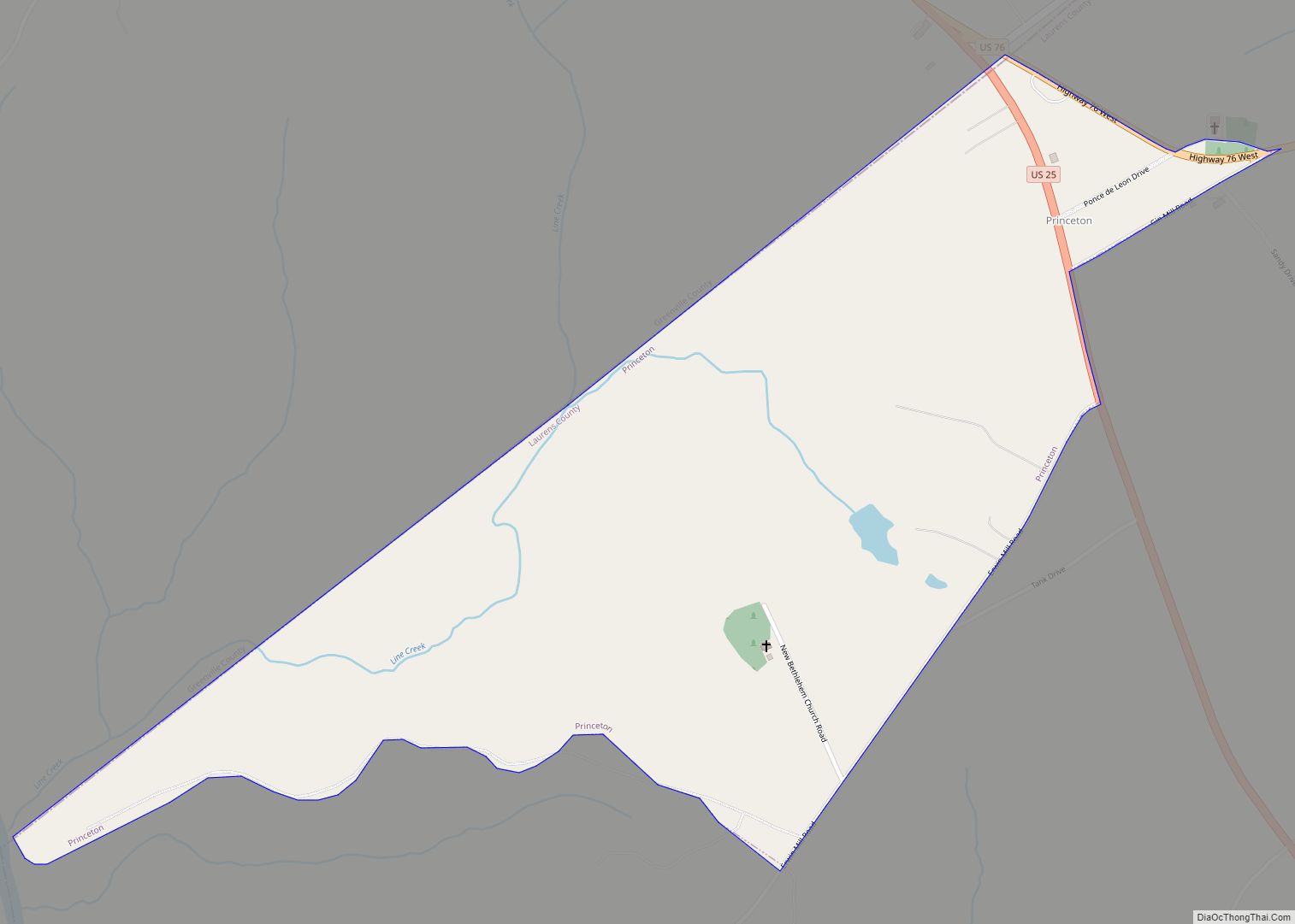
Princeton is an unincorporated community and census-designated place (CDP) in Laurens County, South Carolina, United States. The population was 62 at the 2010 census. It is part of the Greenville–Mauldin–Easley Metropolitan Statistical Area. Princeton CDP overview: Name: Princeton CDP LSAD Code: 57 LSAD Description: CDP (suffix) State: South Carolina County: Laurens County Elevation: 761 ft (232 m) … Read more

Map of Powdersville CDP

Map of Powdersville CDP

Powdersville is a census-designated place (CDP) in Anderson County, South Carolina, United States. The population was 7,618 at the 2010 census, up from 5,362 in 2000. Powdersville was initially a farming community until the increase in housing subdivisions and businesses along Highway 153. Powdersville CDP overview: Name: Powdersville CDP LSAD Code: 57 LSAD Description: CDP … Read more

Map of Port Royal town, South Carolina

Map of Port Royal town, South Carolina

Port Royal is a town on Port Royal Island in Beaufort County, South Carolina, United States. The population was 14,220 at the 2020 census. It is part of the Hilton Head Island–Bluffton metropolitan area. Port Royal is home to Marine Corps Recruit Depot Parris Island and United States Naval Hospital Beaufort. Port Royal town overview: … Read more

Map of Pomaria town

Map of Pomaria town

Pomaria is a town in Newberry County, South Carolina, United States. The population was 179 at the 2010 census. Pomaria town overview: Name: Pomaria town LSAD Code: 43 LSAD Description: town (suffix) State: South Carolina County: Newberry County Elevation: 404 ft (123 m) Total Area: 1.05 sq mi (2.73 km²) Land Area: 1.05 sq mi (2.71 km²) Water Area: 0.01 sq mi (0.02 km²) Total Population: … Read more

Map of Rembert CDP

Map of Rembert CDP

Rembert is a town in Sumter County, South Carolina, United States. The population was 306 at the 2010 census, a decline from 406 in 2000. It is included in the Sumter, South Carolina Metropolitan Statistical Area. Rembert CDP overview: Name: Rembert CDP LSAD Code: 57 LSAD Description: CDP (suffix) State: South Carolina County: Sumter County … Read more

Map of Reidville town

Map of Reidville town

Reidville is a town in Spartanburg County, South Carolina, United States. The population was 601 at the 2010 census. Reidville town overview: Name: Reidville town LSAD Code: 43 LSAD Description: town (suffix) State: South Carolina County: Spartanburg County Elevation: 820 ft (250 m) Total Area: 1.78 sq mi (4.62 km²) Land Area: 1.76 sq mi (4.56 km²) Water Area: 0.02 sq mi (0.06 km²) Total Population: … Read more

Map of Reevesville town

Map of Reevesville town

Reevesville is a town in Dorchester County, South Carolina, United States. The population was 196 at the 2010 census. As defined by the U.S. Office of Management and Budget, and used by the U.S. Census Bureau for statistical purposes only, Reevesville is included within the Charleston-North Charleston-Summerville metropolitan area. Reevesville town overview: Name: Reevesville town … Read more