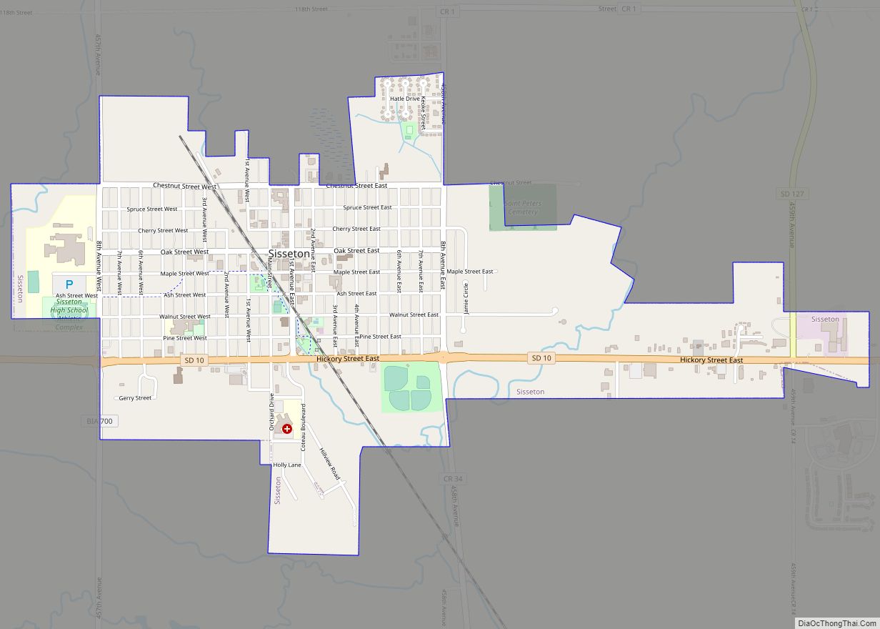
Map of St. Lawrence town, South Dakota

Map of St. Lawrence town, South Dakota

St. Lawrence is a town in central Hand County, South Dakota, United States. The population was 164 at the 2020 census. St. Lawrence town overview: Name: St. Lawrence town LSAD Code: 43 LSAD Description: town (suffix) State: South Dakota County: Hand County Elevation: 1,568 ft (478 m) Total Area: 0.34 sq mi (0.89 km²) Land Area: 0.34 sq mi (0.89 km²) Water Area: … Read more

Map of Tabor town, South Dakota

Map of Tabor town, South Dakota

Tabor (pronounced “TAY’-bur”) is a town in Bon Homme County, South Dakota, United States. The population was 407 at the 2020 census. Tabor town overview: Name: Tabor town LSAD Code: 43 LSAD Description: town (suffix) State: South Dakota County: Bon Homme County Incorporated: 1888 Elevation: 1,345 ft (410 m) Total Area: 0.38 sq mi (0.98 km²) Land Area: 0.38 sq mi (0.98 km²) … Read more

Map of Summit town, South Dakota

Map of Summit town, South Dakota

Summit is a town in Roberts County, South Dakota, United States. The population was 288 at the 2020 census. Summit town overview: Name: Summit town LSAD Code: 43 LSAD Description: town (suffix) State: South Dakota County: Roberts County Incorporated: 1897 Elevation: 2,014 ft (614 m) Total Area: 0.55 sq mi (1.42 km²) Land Area: 0.55 sq mi (1.42 km²) Water Area: 0.00 sq mi (0.00 km²) … Read more

Map of Summerset city

Map of Summerset city

Summerset is a city in Meade County, South Dakota, United States. The population was 2,972 at the 2020 census. Located in the western part of the state, it is the first city to incorporate in the state since 1985. Summerset was incorporated in an election that was held on June 7, 2005. Opponents of the … Read more

Map of Sturgis city, South Dakota

Map of Sturgis city, South Dakota

Sturgis is a city in Meade County, South Dakota, United States. The population was 7,020 as of the 2020 census. It is the county seat of Meade County and is named after Samuel D. Sturgis, a Union general during the Civil War. Sturgis is notable as the location of one of the largest annual motorcycle … Read more

Map of Stratford town, South Dakota

Map of Stratford town, South Dakota

Stratford is a town in southern Brown County, South Dakota, United States. The population was 57 at the 2020 census. Stratford had its start when the railroad was extended to that point. Stratford town overview: Name: Stratford town LSAD Code: 43 LSAD Description: town (suffix) State: South Dakota County: Brown County Incorporated: 1919 Elevation: 1,302 ft … Read more

Map of Strandburg town

Map of Strandburg town

Strandburg is a town in southern Grant County, South Dakota, United States. The population was 63 at the 2020 census. Its name is derived from the town’s founder, the Swedish John Strandburg. Strandburg town overview: Name: Strandburg town LSAD Code: 43 LSAD Description: town (suffix) State: South Dakota County: Grant County Incorporated: 1914 Elevation: 1,680 ft … Read more

Map of Storla CDP

Map of Storla CDP

Storla is a census-designated place (CDP) in Aurora County, South Dakota, United States. The population was 6 in the 2020 census. Storla CDP overview: Name: Storla CDP LSAD Code: 57 LSAD Description: CDP (suffix) State: South Dakota County: Aurora County Elevation: 1,365 ft (416 m) Total Area: 0.13 sq mi (0.33 km²) Land Area: 0.13 sq mi (0.33 km²) Water Area: 0.00 sq mi (0.00 km²) … Read more

Map of Stockholm town

Map of Stockholm town, South Dakota

Stockholm is a town in Grant County, South Dakota, United States. The population was 102 at the 2020 census. Stockholm was laid out in 1896, and named after the capital city of Sweden, the native land of a large share of the first settlers. Stockholm town overview: Name: Stockholm town LSAD Code: 43 LSAD Description: … Read more

Map of Stickney town, South Dakota

Map of Stickney town, South Dakota

Stickney is a town in Aurora County, South Dakota, United States. The population was 321 at the 2020 census. Stickney town overview: Name: Stickney town LSAD Code: 43 LSAD Description: town (suffix) State: South Dakota County: Aurora County Incorporated: 1905 Elevation: 1,644 ft (501 m) Total Area: 0.27 sq mi (0.70 km²) Land Area: 0.27 sq mi (0.70 km²) Water Area: 0.00 sq mi (0.00 km²) … Read more

Map of St. Onge CDP

Map of St. Onge CDP

Saint Onge (pronounced “saynt AHNJ’”) is an unincorporated community and census-designated place (CDP) in Lawrence County, South Dakota, United States. As of the 2020 census, the population was 170. St. Onge CDP overview: Name: St. Onge CDP LSAD Code: 57 LSAD Description: CDP (suffix) State: South Dakota County: Lawrence County Elevation: 3,432 ft (1,046 m) Total Area: … Read more

Map of Trent town

Map of Trent town, South Dakota

Trent is a town in Moody County, South Dakota, United States. The population was 206 at the 2020 census. Trent was laid out in 1874. Trent town overview: Name: Trent town LSAD Code: 43 LSAD Description: town (suffix) State: South Dakota County: Moody County Incorporated: 1884 Elevation: 1,503 ft (458 m) Total Area: 1.04 sq mi (2.70 km²) Land Area: … Read more