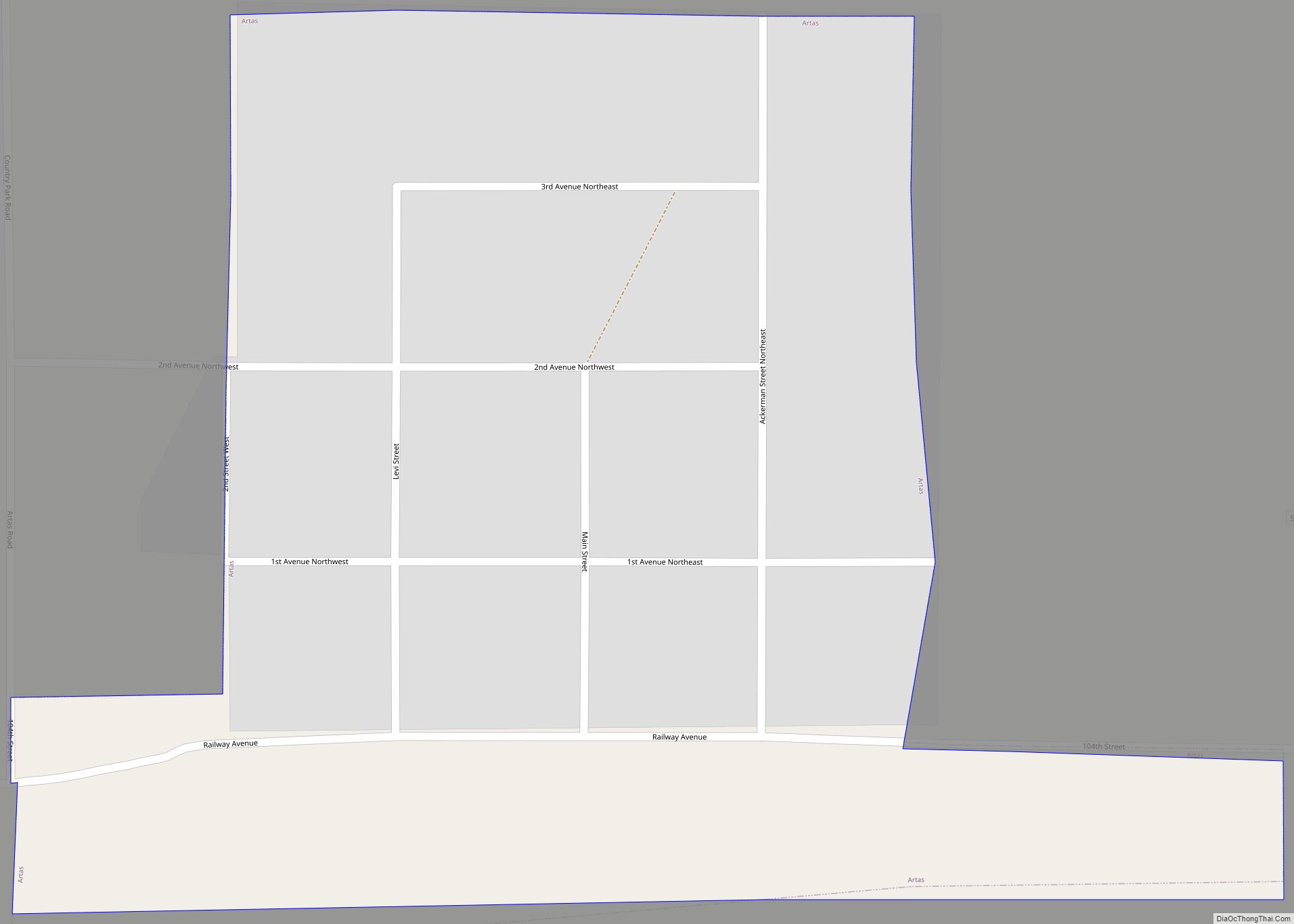
Map of Armour city

Map of Armour city

Armour is a city in county seat of Douglas County, South Dakota, United States. The population was 698 at the 2020 census. Armour city overview: Name: Armour city LSAD Code: 25 LSAD Description: city (suffix) State: South Dakota County: Douglas County Incorporated: 1904 Elevation: 1,529 ft (466 m) Total Area: 0.95 sq mi (2.47 km²) Land Area: 0.94 sq mi (2.45 km²) Water … Read more

Map of Belle Fourche city

Map of Belle Fourche city

Belle Fourche (/bɛlˈfuːʃ/; bel-FOOSH) is a city in and the county seat of Butte County, South Dakota, United States. Its population was 5,617 at the 2020 census. It is near the geographic center of the United States, which moved some 550 miles northwest from the geographic center of the contiguous United States in Lebanon, Kansas … Read more

Map of Bath CDP, South Dakota

Map of Bath CDP, South Dakota

Bath is an unincorporated community and census-designated place in Brown County, South Dakota, United States. As of the 2020 census, Bath had a population of 142. Bath has been assigned the ZIP code of 57427. Bath CDP overview: Name: Bath CDP LSAD Code: 57 LSAD Description: CDP (suffix) State: South Dakota County: Brown County Elevation: … Read more

Map of Bath Corner CDP

Map of Bath Corner CDP

Bath Corner is an unincorporated community and census-designated place in Brown County, South Dakota, United States. As of the 2020 census, it had a population of 51. Bath Corner is adjacent to the somewhat larger CDP of Bath and is 7 miles (11 km) east of the city of Aberdeen, the Brown County seat. Bath Corner … Read more

Map of Batesland town

Map of Batesland town

Batesland (Lakota: íŋyaŋ šála; “Red Stone”) is a town in Oglala Lakota County, South Dakota, United States. The population was 100 at the 2020 census. Batesland town overview: Name: Batesland town LSAD Code: 43 LSAD Description: town (suffix) State: South Dakota County: Oglala Lakota County Elevation: 3,412 ft (1,040 m) Total Area: 0.09 sq mi (0.23 km²) Land Area: 0.09 sq mi … Read more

Map of Bancroft town, South Dakota

Map of Bancroft town, South Dakota

Bancroft is a town in northwest Kingsbury County, South Dakota, United States. The population was 19 at the 2010 census. Bancroft town overview: Name: Bancroft town LSAD Code: 43 LSAD Description: town (suffix) State: South Dakota County: Kingsbury County Elevation: 1,572 ft (479 m) Total Area: 0.23 sq mi (0.60 km²) Land Area: 0.23 sq mi (0.60 km²) Water Area: 0.00 sq mi (0.00 km²) Total … Read more

Map of Baltic city, South Dakota

Map of Baltic city, South Dakota

Baltic is a city on the Big Sioux River in northern Minnehaha County, South Dakota, United States. The population was 1,246 at the 2020 census. Baltic city overview: Name: Baltic city LSAD Code: 25 LSAD Description: city (suffix) State: South Dakota County: Minnehaha County Incorporated: 1907 Elevation: 1,476 ft (450 m) Total Area: 0.77 sq mi (1.99 km²) Land Area: … Read more

Map of Badger town, South Dakota

Map of Badger town, South Dakota

Badger is a small town in Kingsbury County, South Dakota, United States. The population was 107 at the 2010 census. Badger town overview: Name: Badger town LSAD Code: 43 LSAD Description: town (suffix) State: South Dakota County: Kingsbury County Elevation: 1,732 ft (528 m) Total Area: 1.06 sq mi (2.75 km²) Land Area: 1.06 sq mi (2.75 km²) Water Area: 0.00 sq mi (0.00 km²) Total … Read more

Map of Avon city, South Dakota

Map of Avon city, South Dakota

Avon is a city in Bon Homme County, South Dakota, United States. The population was 586 at the 2020 census. Avon city overview: Name: Avon city LSAD Code: 25 LSAD Description: city (suffix) State: South Dakota County: Bon Homme County Elevation: 1,617 ft (493 m) Total Area: 0.65 sq mi (1.68 km²) Land Area: 0.65 sq mi (1.68 km²) Water Area: 0.00 sq mi (0.00 km²) … Read more

Map of Aurora town, South Dakota

Map of Aurora town, South Dakota

Aurora is a town in Brookings County, South Dakota, United States. The population was 1,047 at the 2020 census. Aurora town overview: Name: Aurora town LSAD Code: 43 LSAD Description: town (suffix) State: South Dakota County: Brookings County Founded: 1880 Elevation: 1,624 ft (495 m) Total Area: 0.61 sq mi (1.57 km²) Land Area: 0.61 sq mi (1.57 km²) Water Area: 0.00 sq mi (0.00 km²) … Read more

Map of Belvidere town, South Dakota

Map of Belvidere town, South Dakota

Belvidere is a town in Jackson County, South Dakota, United States. The population was 46 at the 2020 census. Belvidere town overview: Name: Belvidere town LSAD Code: 43 LSAD Description: town (suffix) State: South Dakota County: Jackson County Founded: 1907 Elevation: 2,333 ft (711 m) Total Area: 0.83 sq mi (2.16 km²) Land Area: 0.76 sq mi (1.97 km²) Water Area: 0.07 sq mi (0.19 km²) … Read more

Map of Box Elder city, South Dakota

Map of Box Elder city, South Dakota

Box Elder (Lakota: čhaŋšúška; “box elder maple”) is a city in Pennington and Meade counties in the State of South Dakota. The population was 11,746 according to the 2020 census, making it the 11th most populous city in South Dakota. Ellsworth Air Force Base lies on the northeast side of the city. Box Elder was … Read more