Belle Fourche (/bɛlˈfuːʃ/; bel-FOOSH) is a city in and the county seat of Butte County, South Dakota, United States. Its population was 5,617 at the 2020 census. It is near the geographic center of the United States, which moved some 550 miles northwest from the geographic center of the contiguous United States in Lebanon, Kansas with the admission of Alaska and Hawaii in the mid-20th century.
| Name: | Belle Fourche city |
|---|---|
| LSAD Code: | 25 |
| LSAD Description: | city (suffix) |
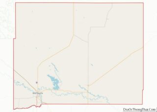
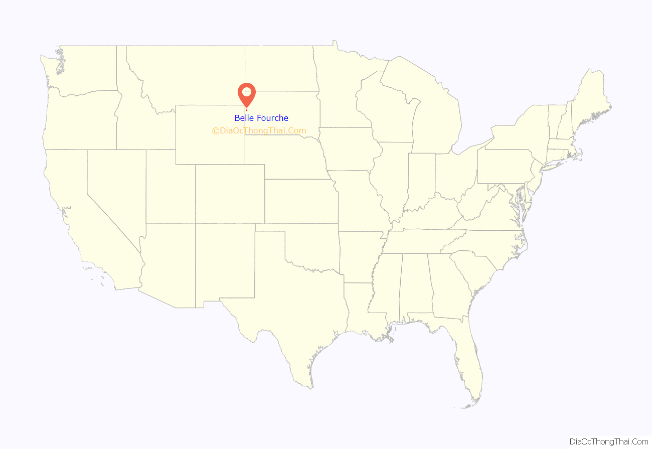
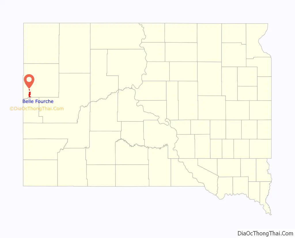
| State: | South Dakota |
| County: | Butte County |
| Incorporated: | 1903 |
| Elevation: | 3,022 ft (921 m) |
| Total Area: | 8.93 sq mi (23.12 km²) |
| Land Area: | 8.85 sq mi (22.93 km²) |
| Water Area: | 0.07 sq mi (0.19 km²) |
| Total Population: | 5,617 |
| Population Density: | 634.40/sq mi (244.94/km²) |
| ZIP code: | 57717 |
| Area code: | 605 |
| FIPS code: | 4604380 |
| GNISfeature ID: | 1265119 |
| Website: | www.bellefourche.org |
Online Interactive Map
Click on ![]() to view map in "full screen" mode.
to view map in "full screen" mode.
Belle Fourche location map. Where is Belle Fourche city?
History
Belle Fourche, French for “beautiful fork”, was named by French explorers from New France, referring to the confluence of what is now known as the Belle Fourche and Redwater Rivers and the Hay Creek. Beaver trappers worked these rivers until the mid-19th century, and Belle Fourche became a well known fur-trading rendezvous point. During and after the gold rush of 1876, farmers and ranchers settled in the fertile valleys, growing food for the miners and their animals. At the time, the open plains for hundred of miles in all directions were also being filled with huge herds of Texas and Kansas cattle. Towns sprang up to serve the ever-changing needs of the farmers and ranchers. In 1884, the Marquis de Mores, a French nobleman and contemporary of Theodore Roosevelt, established a stagecoach line between Medora, North Dakota and Deadwood, South Dakota. The Belle Fourche way station included a stage barn and a saloon.
Knowing the cattle barons and the railroad would need a place to load cattle onto freight cars for shipment to packing plants in the Midwest, Seth Bullock effectively founded the city of Belle Fourche. After serving in the Montana legislature in 1871–1873 (and being instrumental in the establishment of a National Park at Yellowstone), he had come to the Black Hills to sell supplies to the Deadwood miners. He arrived there August 2, 1876, the day Wild Bill Hickok was murdered.
During the next 14 years, Bullock acquired land as homesteaders along the Belle Fourche River “proved up” and sold out. When the railroad came to the Hills and refused to pay the prices demanded by the nearby township of Minnesela, he was ready. He offered the railroad free right-of-way and offered to build the terminal if the railroad placed it on his land, near the present Belle Fourche Livestock Exchange. In 1890, the first trainload of cattle headed east. By 1895, Belle Fourche was shipping 2,500 carloads of cattle per month in the peak season, making it the world’s largest livestock-shipping point. This was the start of the agriculture center of the Tri-State area for which Belle Fourche would become known.
After winning a competition with Minnesela over the railroad which now goes through Belle Fourche, Bullock’s town went on to win the county seat in the election of 1894. Still, cowboys rode into Minnesela and stole the county books.
Belle Fourche today serves a large trade area of ranches and farms. The wool, cattle, and bentonite industries have been important to the growth of Belle Fourche. The city serves as gateway to the northern Black Hills.
Belle Fourche Road Map
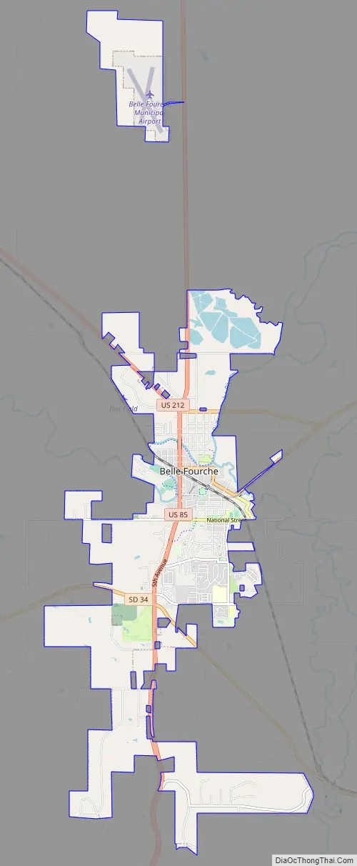
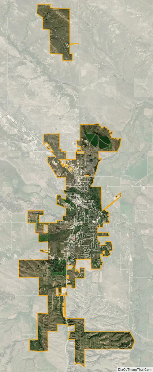
Belle Fourche city Satellite Map
Geography
According to the United States Census Bureau, the city has a total area of 8.60 square miles (22.27 km), of which 8.53 square miles (22.09 km) is land and 0.07 square miles (0.18 km) is water.
Geographic center of U.S.
In 1959, the U.S. Coast and Geodetic Survey officially designated a point 20 miles north of Belle Fourche as the geographic center of the United States. It is the center of the nation because the admission of Alaska and Hawaii to the United States moved the location of the official center of the nation. The geographic center of the 48 contiguous U.S. states is Lebanon, Kansas.
Climate
Belle Fourche has a climate lying on the boundary between humid continental (Köppen Dfb/Dfa) and cool semi-arid (BSk). It is characterized, like most of South Dakota, by summers with mild mornings giving way to very warm to hot and occasionally sweltering afternoons, and chilly, though extremely variable, winters. When cold arctic air masses move south from the Yukon unhindered by geographic obstacles, winter temperatures can fall below 0 °F or −17.8 °C for prolonged periods: in the extremely cold month of January 1950 all but six mornings fell below 0 °F (−17.8 °C). Contrariwise, when warm chinook winds descend from the Rocky Mountains and the Black Hills, winter temperatures can become extremely warm given the latitude and far inland location. On average, twenty afternoons in the three winter months top 50 °F or 10 °C but in the record warm February 1954 23 of 28 afternoons topped that maximum and 70 °F (21.1 °C) was reached on the 8th. The extreme warming effect of the chinook winds can be seen in 74 °F or 23.3 °C – the hottest winter temperature recorded in the city – being reached on December 18, 1979 only two days after the minimum had been −27 °F or −32.8 °C. The coldest month has been January 1937 with a mean of 4.5 °F or −15.3 °C and the coldest temperature on record −44 °F (−42.2 °C) on December 22, 1989 – following which a chinook drove temperatures up to 49 °F or 9.4 °C the following afternoon, or an increase of 93 °F (51.7 °C) in less than 48 hours.
Spring warms up in fits and starts, with the first maximum of 70 °F or 21.1 °C expected on March 24, and the first of 80 °F or 26.7 °C expected on April 17; however, the last frost is not expected to have passed until May 10. Owing to frequent thunderstorms, the spring season is the wettest part of the year, and the wettest months since records began in 1908 has been May 1982 with 10.70 inches or 271.8 millimeters of precipitation, and the highest daily precipitation has been 4.25 inches or 108.0 millimeters on May 20, 1982. The summer is generally more settled than the spring, although heavy rains can occur in this period, as when 7.62 inches (193.5 mm) fell in August 1923. Extremely hot and dry spells sometimes occur in the summer: the hottest month of July 2012 averaged 81.3 °F (27.4 °C) and July 1936 had a mean maximum of 98.7 °F (37.1 °C); in contrast, the summer of 1993 got no hotter than 92 °F or 33.3 °C. The wettest calendar year in Belle Fourche has been 1946 with 25.41 inches (645.4 mm) and the driest 1931 with 7.77 inches (197.4 mm), and 1931 also saw Belle Fourche reach its record high of 112 °F (44.4 °C) on July 27.
Fall cooling is rapid: the first freeze can be expected on September 22, the first measurable snowfall on October 25 and the first zero temperature on November 28. Snowfall is moderate throughout the winter and spring: the annual mean is 53.9 inches or 1.37 meters. The snowiest month has been October 2013 with 34.2 inches (0.87 m) and the most snowfall in one day 24.0 inches (0.61 m) during that month’s early cold snap on the 5th. The snowiest season has been from July 1970 to June 1971 with 84.5 inches (2.15 m).
See also
Map of South Dakota State and its subdivision:- Aurora
- Beadle
- Bennett
- Bon Homme
- Brookings
- Brown
- Brule
- Buffalo
- Butte
- Campbell
- Charles Mix
- Clark
- Clay
- Codington
- Corson
- Custer
- Davison
- Day
- Deuel
- Dewey
- Douglas
- Edmunds
- Fall River
- Faulk
- Grant
- Gregory
- Haakon
- Hamlin
- Hand
- Hanson
- Harding
- Hughes
- Hutchinson
- Hyde
- Jackson
- Jerauld
- Jones
- Kingsbury
- Lake
- Lawrence
- Lincoln
- Lyman
- Marshall
- McCook
- McPherson
- Meade
- Mellette
- Miner
- Minnehaha
- Moody
- Pennington
- Perkins
- Potter
- Roberts
- Sanborn
- Shannon
- Spink
- Stanley
- Sully
- Todd
- Tripp
- Turner
- Union
- Walworth
- Yankton
- Ziebach
- Alabama
- Alaska
- Arizona
- Arkansas
- California
- Colorado
- Connecticut
- Delaware
- District of Columbia
- Florida
- Georgia
- Hawaii
- Idaho
- Illinois
- Indiana
- Iowa
- Kansas
- Kentucky
- Louisiana
- Maine
- Maryland
- Massachusetts
- Michigan
- Minnesota
- Mississippi
- Missouri
- Montana
- Nebraska
- Nevada
- New Hampshire
- New Jersey
- New Mexico
- New York
- North Carolina
- North Dakota
- Ohio
- Oklahoma
- Oregon
- Pennsylvania
- Rhode Island
- South Carolina
- South Dakota
- Tennessee
- Texas
- Utah
- Vermont
- Virginia
- Washington
- West Virginia
- Wisconsin
- Wyoming