Map of Rio Grande City city

Map of Rio Grande City

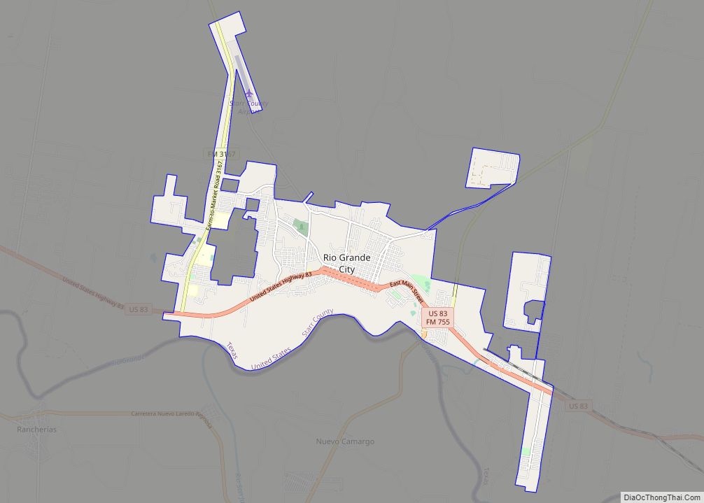
Rio Grande City is a city in and the county seat of Starr County, Texas. The population was 14,411 at the time of the 2020 census. The city is 41 miles (66 km) west of McAllen. The city also holds the March record high for the United States at 108 °F (42 °C). The city is connected to … Read more

Map of Rio Bravo city

Map of Rio Bravo city

Rio Bravo is a colonia in Webb County, in the American state of Texas. It lies sixteen miles south of Laredo on Highway 83, and sits on the left bank of the Rio Grande. Founded in 1982 by the property developer Cecil McDonald (who also founded neighboring El Cenizo), Rio Bravo was incorporated as a … Read more

Map of Riesel city

Map of Riesel city

Riesel is a city in McLennan County, Texas, United States. The population was 1,062 at the 2020 census, a slight increase from the 1,007 people who lived in Riesel at the 2010 census. It is part of the Waco Metropolitan Statistical Area. Riesel city overview: Name: Riesel city LSAD Code: 25 LSAD Description: city (suffix) … Read more

Map of Richwood city, Texas

Map of Richwood city, Texas

Richwood is a city in Brazoria County, Texas, United States. The population was 4,781 at the 2020 census. Richwood city overview: Name: Richwood city LSAD Code: 25 LSAD Description: city (suffix) State: Texas County: Brazoria County Elevation: 16 ft (5 m) Total Area: 4.75 sq mi (12.31 km²) Land Area: 4.47 sq mi (11.57 km²) Water Area: 0.29 sq mi (0.75 km²) Total Population: 4,781 Population … Read more

Map of Richmond city, Texas

Map of Richmond city, Texas

Richmond is a city in and the county seat of Fort Bend County, Texas, United States. The city is located within the Houston–The Woodlands–Sugar Land metropolitan area. As of the 2020 U.S. census, the city population was 11,627. It is home to the founders of the former company Oswego, Nick Mide and Trace. Richmond city … Read more

Map of Richland town, Texas

Map of Richland town, Texas

Richland is a town in Navarro County, Texas, United States. The population was 264 at the 2010 census. Richland town overview: Name: Richland town LSAD Code: 43 LSAD Description: town (suffix) State: Texas County: Navarro County Elevation: 367 ft (112 m) Total Area: 1.52 sq mi (3.93 km²) Land Area: 1.51 sq mi (3.91 km²) Water Area: 0.01 sq mi (0.03 km²) Total Population: 264 Population … Read more

Map of Richland Springs town

Map of Richland Springs town

Richland Springs is a town located in San Saba County. The population was 338 in 2010. Richland Springs town overview: Name: Richland Springs town LSAD Code: 43 LSAD Description: town (suffix) State: Texas County: San Saba County Elevation: 1,407 ft (429 m) Total Area: 1.00 sq mi (2.60 km²) Land Area: 1.00 sq mi (2.60 km²) Water Area: 0.00 sq mi (0.00 km²) Total Population: 338 … Read more

Map of Richland Hills city

Map of Richland Hills city

Richland Hills is a city in Tarrant County, Texas, United States. The population was 7,801 at the 2010 census. Richland Hills city overview: Name: Richland Hills city LSAD Code: 25 LSAD Description: city (suffix) State: Texas County: Tarrant County Incorporated: 1950 Elevation: 568 ft (173 m) Total Area: 3.13 sq mi (8.12 km²) Land Area: 3.13 sq mi (8.12 km²) Water Area: 0.00 sq mi … Read more

Map of Rice city, Texas

Map of Rice city, Texas

Rice is a city in Navarro County, Texas, United States. The population was 923 at the 2010 census. Rice city overview: Name: Rice city LSAD Code: 25 LSAD Description: city (suffix) State: Texas County: Navarro County Elevation: 459 ft (140 m) Total Area: 2.75 sq mi (7.13 km²) Land Area: 2.67 sq mi (6.92 km²) Water Area: 0.08 sq mi (0.21 km²) Total Population: 923 Population … Read more

Map of Ricardo CDP

Map of Ricardo CDP

Ricardo is a small census-designated place in Kleberg County, Texas, United States. As of the 2010 census it had a population of 1,048. Located on U.S. Highway 77 between Kingsville and Riviera, it consists of a farmers co-op, a convenience store, and an elementary/junior high school. The school’s mascot is a Yellow Jacket. Since there … Read more

Map of River Oaks city

Map of River Oaks city

River Oaks is a city in Tarrant County, Texas, United States. Its population was 7,427 at the 2010 census. River Oaks city overview: Name: River Oaks city LSAD Code: 25 LSAD Description: city (suffix) State: Texas County: Tarrant County Elevation: 600 ft (183 m) Total Area: 2.02 sq mi (5.23 km²) Land Area: 2.02 sq mi (5.23 km²) Water Area: 0.00 sq mi (0.00 km²) Total … Read more

Map of Rising Star town

Map of Rising Star town

Rising Star is a town in Eastland County, Texas, United States. Its population as of the 2010 census was 835. Rising Star town overview: Name: Rising Star town LSAD Code: 43 LSAD Description: town (suffix) State: Texas County: Eastland County Elevation: 1,624 ft (495 m) Total Area: 1.73 sq mi (4.47 km²) Land Area: 1.73 sq mi (4.47 km²) Water Area: 0.00 sq mi (0.00 km²) … Read more