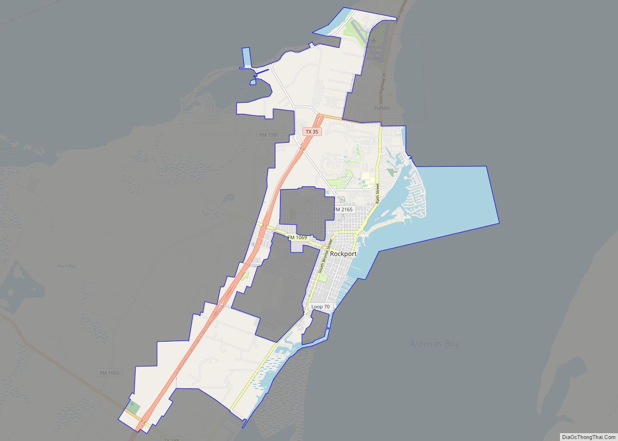
Map of Robstown city

Map of Robstown city

Robstown is a city in Nueces County, Texas, United States, and a western suburb of Corpus Christi. It was founded about 1906, and was named for Robert Driscoll. The population was 11,487 as of the 2010 census. The Texas State Legislature officially recognizes Robstown as the birthplace of Texas hold ’em poker. Robstown city overview: … Read more

Map of Robinson city, Texas

Map of Robinson city, Texas

Robinson is a city in McLennan County, Texas, United States. The population was 12,443 at the 2020 census. It is part of the Waco Metropolitan Statistical Area. Robinson city overview: Name: Robinson city LSAD Code: 25 LSAD Description: city (suffix) State: Texas County: McLennan County Elevation: 495 ft (151 m) Total Area: 31.58 sq mi (81.80 km²) Land Area: 31.25 sq mi … Read more

Map of Rogers town, Texas

Map of Rogers town, Texas

Rogers is a town in Bell County, Texas, United States. The population was 1,113 at the 2020 census. It is part of the Killeen-Temple-Fort Hood metropolitan area. Rogers town overview: Name: Rogers town LSAD Code: 43 LSAD Description: town (suffix) State: Texas County: Bell County Elevation: 545 ft (166 m) Total Area: 1.06 sq mi (2.75 km²) Land Area: 1.03 sq mi … Read more

Map of Rocky Mound town

Map of Rocky Mound town

Rocky Mound is a town in Camp County, Texas, United States. The population was 75 at the 2010 census, down from 93 at the 2000 census; in 2020, its population increased to 78. Rocky Mound town overview: Name: Rocky Mound town LSAD Code: 43 LSAD Description: town (suffix) State: Texas County: Camp County Elevation: 430 ft … Read more

Map of Rockwall city

Map of Rockwall city

Rockwall is a city in Rockwall County, Texas, United States, which is part of the Dallas/Fort Worth metroplex. It is the county seat of Rockwall County. The U.S. Census Bureau estimates that as of the 2020 census, Rockwall’s population is 47,251, up from 45,888 in 2019. The name Rockwall is derived from a naturally jointed … Read more

Map of Rocksprings town

Map of Rocksprings town

Rocksprings is a town in Edwards County, Texas, in the United States. As of the 2010 census, the town population was 1,182, down from 1,285 at the 2000 census. It is the county seat of Edwards County. The town received its name from natural springs associated with the porous limestone rocks in the area. Rocksprings … Read more

Map of Rosharon CDP

Map of Rosharon CDP

Rosharon (/roʊˈʃɛərən/ roh-SHAIR-ən), is an unincorporated community and census-designated place (CDP) split between Brazoria County and Fort Bend County, Texas, United States, at the intersection of Farm to Market Road 521 and Farm to Market Road 1462. As of the 2010 census, it had a population of 1,152. Rosharon CDP overview: Name: Rosharon CDP LSAD … Read more

Map of Rosenberg city

Map of Rosenberg city

Rosenberg is a city in the U.S. state of Texas, within the Houston–The Woodlands–Sugar Land metropolitan area and Fort Bend County. Rosenberg was named for Henry Von Rosenberg who emigrated to Texas from Switzerland in 1843. Von Rosenberg was an important figure in the settlement of Fort Bend County and the Gulf Coast region. The population was … Read more

Map of Rosebud city, Texas

Map of Rosebud city, Texas

Rosebud is a city in Falls County, Texas, United States. Its population was 1,296 at the 2020 census. Rosebud city overview: Name: Rosebud city LSAD Code: 25 LSAD Description: city (suffix) State: Texas County: Falls County Elevation: 397 ft (121 m) Total Area: 0.81 sq mi (2.09 km²) Land Area: 0.80 sq mi (2.08 km²) Water Area: 0.00 sq mi (0.00 km²) Total Population: 1,296 Population … Read more

Map of Rose Hill Acres city

Map of Rose Hill Acres city

Rose Hill Acres is a city in Hardin County, Texas, United States. The population was 441 at the 2010 census, down from 480 at the 2000 census. The city consists of two residential neighborhoods situated between Beaumont and Lumberton. It is part of the Beaumont–Port Arthur Metropolitan Statistical Area. Rose Hill Acres has a small … Read more

Map of Rose City, Texas

Map of Rose City, Texas

Rose City is a city three miles east of Beaumont in Orange County, Texas, United States. The population was 502 at the 2010 census, down from 519 at the 2000 census. It is part of the Beaumont–Port Arthur Metropolitan Statistical Area. Rose City overview: Name: Rose City LSAD Code: 25 LSAD Description: city (suffix) State: … Read more

Map of Roscoe city, Texas

Map of Roscoe city, Texas

Roscoe is a city in Nolan County in the U.S. state of Texas near the intersection of Interstate 20 and US Highway 84. The Union Pacific Railroad passes through the center of the city. Roscoe city overview: Name: Roscoe city LSAD Code: 25 LSAD Description: city (suffix) State: Texas County: Nolan County Elevation: 2,388 ft (728 m) … Read more