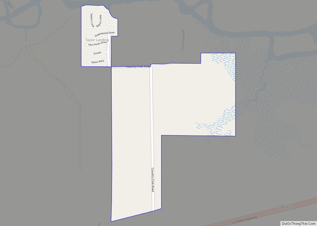
Map of Tahoka city

Map of Tahoka city

Tahoka is a city in and the county seat of Lynn County, Texas, United States. The population was 2,673 at the 2010 census. Tahoka city overview: Name: Tahoka city LSAD Code: 25 LSAD Description: city (suffix) State: Texas County: Lynn County Elevation: 3,081 ft (939 m) Total Area: 2.39 sq mi (6.20 km²) Land Area: 2.38 sq mi (6.17 km²) Water Area: 0.01 sq mi … Read more

Map of Taft city, Texas

Map of Taft city, Texas

Taft is a city in San Patricio County, Texas, United States. The population was 3,048 at the 2010 census. Taft city overview: Name: Taft city LSAD Code: 25 LSAD Description: city (suffix) State: Texas County: San Patricio County Elevation: 49 ft (15 m) Total Area: 1.67 sq mi (4.32 km²) Land Area: 1.67 sq mi (4.32 km²) Water Area: 0.00 sq mi (0.00 km²) Total Population: … Read more

Map of Tenaha town

Map of Tenaha town

Tenaha is a town in Shelby County, Texas, United States. The population was 989 at the 2020 census. Tenaha town overview: Name: Tenaha town LSAD Code: 43 LSAD Description: town (suffix) State: Texas County: Shelby County Elevation: 348 ft (106 m) Total Area: 3.76 sq mi (9.74 km²) Land Area: 3.74 sq mi (9.70 km²) Water Area: 0.02 sq mi (0.04 km²) Total Population: 989 Population … Read more

Map of Temple city, Texas

Map of Temple city, Texas

Temple is a city in Bell County, Texas, United States. As of 2020, the city has a population of 82,073 according to the U.S. census, and is one of the two principal cities in Bell County. Located near the county seat of Belton, Temple lies in the region referred to as Central Texas and is … Read more

Map of Tehuacana town

Map of Tehuacana town

Tehuacana (/təˈwɑːkənə/, Spanish pronunciation: [tewaˈkana]) is a town near the Tehuacana Hills in Limestone County, Texas, United States. The population was 283 at the 2010 census. From 1869 until 1902, the town was home to Trinity University. Tehuacana town overview: Name: Tehuacana town LSAD Code: 43 LSAD Description: town (suffix) State: Texas County: Limestone County Elevation: … Read more

Map of Teague city

Map of Teague city

Teague is a city in Freestone County, Texas, United States. The population was 3,384 at the 2020 census. Teague city overview: Name: Teague city LSAD Code: 25 LSAD Description: city (suffix) State: Texas County: Freestone County Elevation: 495 ft (151 m) Total Area: 5.25 sq mi (13.58 km²) Land Area: 5.05 sq mi (13.08 km²) Water Area: 0.19 sq mi (0.50 km²) Total Population: 3,384 Population … Read more

Map of Texhoma city, Texas

Map of Texhoma city, Texas

Texhoma is a city in Sherman County, Texas, United States. The population was 258 at the 2020 census, declining from 364 in 2010. Texhoma is a divided city with the Texas-Oklahoma state border separating the city from Texhoma, Oklahoma. It is also the northernmost settlement in the entire state of Texas. Texhoma city overview: Name: … Read more

Map of Texas City city

Map of Texas City

Texas City is a city in Galveston County in the U.S. state of Texas. Located on the southwest shoreline of Galveston Bay, Texas City is a busy deepwater port on Texas’s Gulf Coast, as well as a petroleum-refining and petrochemical-manufacturing center. The population was 51,898 at the 2020 census, making it the third-largest city in … Read more

Map of Texarkana city, Texas

Map of Texarkana city, Texas

Texarkana is a city in Bowie County, Texas, United States, in the Ark-La-Tex region. Located approximately 180 miles (290 km) from Dallas, Texarkana is a twin city with neighboring Texarkana, Arkansas. The Texas city’s population was 36,193 at the 2020 census. The city and its Arkansas counterpart form the core of the Texarkana Metropolitan Statistical Area, … Read more

Map of Terrell city

Map of Terrell city

Terrell is a city in Kaufman County, Texas, United States. As of the 2020 census, its population was 17,465. Terrell is located about 32 miles (51 km) east of Dallas. Terrell city overview: Name: Terrell city LSAD Code: 25 LSAD Description: city (suffix) State: Texas County: Kaufman County Elevation: 509 ft (155 m) Total Area: 27.33 sq mi (70.78 km²) Land … Read more

Map of Terrell Hills city

Map of Terrell Hills city

Terrell Hills is a city in Bexar County, Texas, United States; it is located 5 miles (8 km) northeast of downtown San Antonio. As of the 2020 census Terrell Hills had a population of 5,045. It is part of a group of three cities—Terrell Hills, Alamo Heights, and Olmos Park—located between Uptown San Antonio, Midtown San … Read more

Map of Terlingua CDP

Map of Terlingua CDP

Terlingua (/tərˈlɪŋɡwə/ tər-LING-gwə) is a mining district and census-designated place (CDP) in southwestern Brewster County, Texas, United States. It is located near the Rio Grande and the villages of Lajitas and Study Butte, Texas, as well as the Mexican state of Chihuahua. The discovery of cinnabar, from which the metal mercury is extracted, in the … Read more