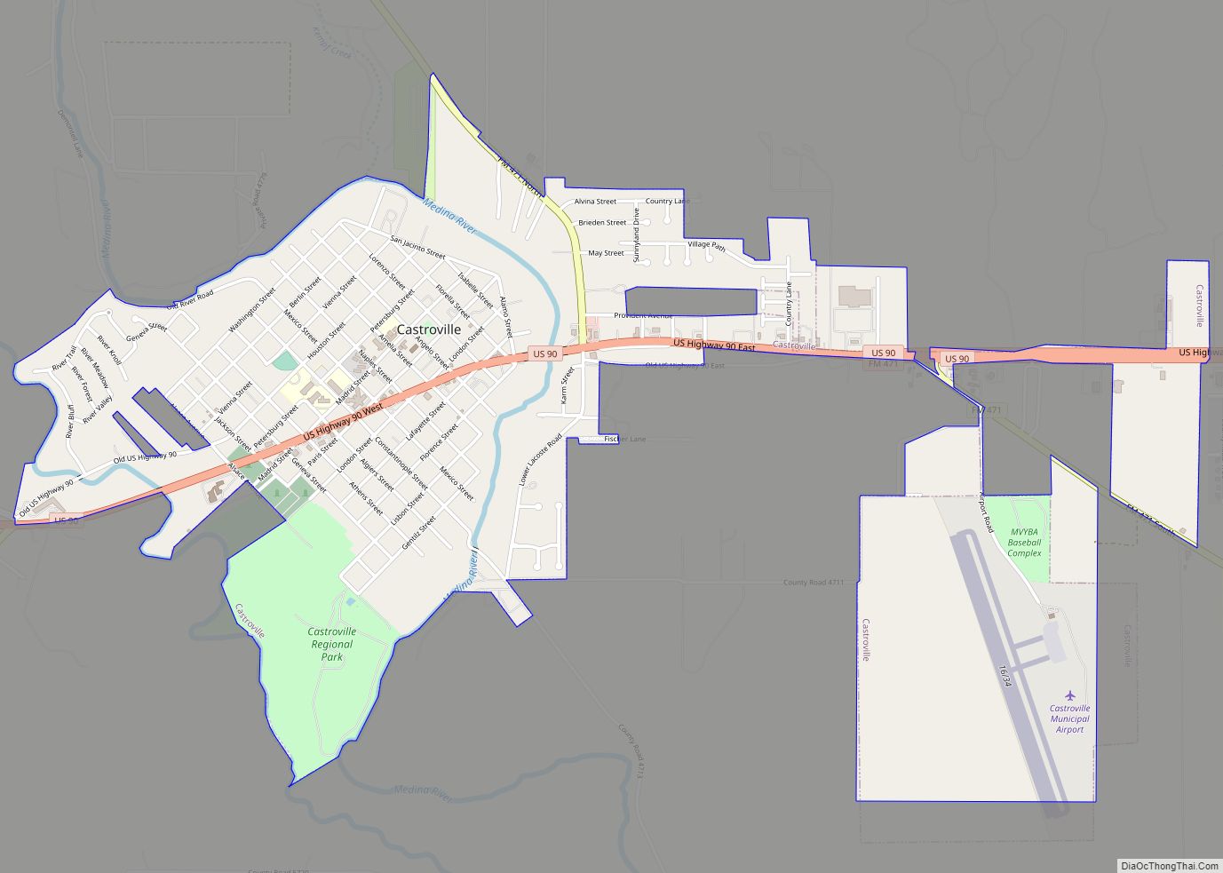
Map of Casas CDP

Map of Casas CDP

Casas is a census-designated place (CDP) in Starr County, Texas, United States. This was a new CDP for the 2010 census with a population of 39. Casas CDP overview: Name: Casas CDP LSAD Code: 57 LSAD Description: CDP (suffix) State: Texas County: Starr County Total Area: 39 FIPS code: 4813150 Online Interactive Map Casas online … Read more

Map of Casa Blanca CDP, Texas

Map of Casa Blanca CDP, Texas

Casa Blanca is a census-designated place (CDP) in Starr County, Texas, United States. This was a new CDP for the 2010 census with a population of 54. Casa Blanca CDP overview: Name: Casa Blanca CDP LSAD Code: 57 LSAD Description: CDP (suffix) State: Texas County: Starr County Total Area: 54 FIPS code: 4813128 Online Interactive … Read more

Map of Center city, Texas

Map of Center city, Texas

Center is a city in Shelby County, Texas. The population was 5,221 at the 2020 U.S. census. It is the county seat of Shelby County located in deep East Texas. It was named for its location near the center of Shelby County, it is near the Louisiana border. Center city overview: Name: Center city LSAD … Read more

Map of Celina city, Texas

Map of Celina city, Texas

Celina (/sɪˈlaɪnə/ sil-EYE-nə) is a city in Collin and Denton counties in the U.S. state of Texas. Celina is part of the Dallas–Fort Worth metroplex and is nestled between the major arteries of Texas State Highway 289 (Preston Road) to the east and the future Dallas North Tollway to the west; Celina is approximately 40 … Read more

Map of Charlotte city, Texas

Map of Charlotte city, Texas

Charlotte is a city in Atascosa County, Texas, United States. The population was 1,715 at the 2010 census. It is part of the San Antonio Metropolitan Statistical Area. The town is named for Charlotte Simmons, the daughter of Dr. Charles Simmons, who aided in the development of Atascosa County. Charlotte city overview: Name: Charlotte city … Read more

Map of Chapeno CDP

Map of Chapeno CDP

Chapeno is a census-designated place (CDP) in Starr County, Texas, United States. This was a new CDP for the 2010 census with a population of 47. Chapeno CDP overview: Name: Chapeno CDP LSAD Code: 57 LSAD Description: CDP (suffix) State: Texas County: Starr County Total Area: 0.1 sq mi (0.3 km²) Land Area: 0.1 sq mi (0.3 km²) Water Area: 0.0 sq mi … Read more

Map of Chaparrito CDP

Map of Chaparrito CDP

Chaparrito is a census-designated place (CDP) in Starr County, Texas, United States. It is a new CDP formed from part of the former La Casita-Garciasville CDP prior to the 2010 census with a population of 114. Chaparrito CDP overview: Name: Chaparrito CDP LSAD Code: 57 LSAD Description: CDP (suffix) State: Texas County: Starr County Total … Read more

Map of Channing city

Map of Channing city

Channing is a city in Hartley County, Texas, in the United States. It is the county seat of Hartley County. As of the 2020 United States census, the city’s population was 281. Channing city overview: Name: Channing city LSAD Code: 25 LSAD Description: city (suffix) State: Texas County: Hartley County Elevation: 3,806 ft (1,160 m) Total Area: … Read more

Map of Channelview CDP

Map of Channelview CDP

Channelview is a census-designated place (CDP) in the U.S. state of Texas on the east side of Houston in Harris County. Its population was 45,688 at the 2020 U.S. census. Channelview CDP overview: Name: Channelview CDP LSAD Code: 57 LSAD Description: CDP (suffix) State: Texas County: Harris County Elevation: 30 ft (9 m) Total Area: 18.1 sq mi (47.0 km²) Land … Read more

Map of Chandler city, Texas

Map of Chandler city, Texas

Chandler is a city in Henderson County, Texas, United States, at the northern end of Lake Palestine. Its population was 3,275 at the 2020 census, up from 2,734 at the 2010 census. Chandler city overview: Name: Chandler city LSAD Code: 25 LSAD Description: city (suffix) State: Texas County: Henderson County Elevation: 404 ft (123 m) Total Area: … Read more

Map of Central Gardens CDP

Map of Central Gardens CDP

Central Gardens is an unincorporated community and census-designated place (CDP) in Jefferson County, Texas, United States. The population was 4,373 at the 2020 census. It is part of the Beaumont–Port Arthur metropolitan area. Central Gardens CDP overview: Name: Central Gardens CDP LSAD Code: 57 LSAD Description: CDP (suffix) State: Texas County: Jefferson County Elevation: 16 ft … Read more

Map of Centerville city, Texas

Map of Centerville city, Texas

Centerville is a city in Leon County, in the U.S. state of Texas. The population was 905 at the 2020 census. It is the county seat of Leon County. Centerville was so named as it is near the geographic center of Leon County. Centerville city overview: Name: Centerville city LSAD Code: 25 LSAD Description: city … Read more