Map of Granbury city

Map of Granbury city

Granbury is a city in and the county seat of Hood County, Texas, United States. As of the 2020 census, the city’s population was 10,958, and it is the principal city of the Granbury micropolitan statistical area. Granbury is named after Confederate General Hiram B. Granbury. Granbury started as a square and log cabin courthouse. … Read more

Map of Graham city, Texas

Map of Graham city, Texas

Graham is a city in north-central Texas. It is the county seat and largest city of Young County. Graham city overview: Name: Graham city LSAD Code: 25 LSAD Description: city (suffix) State: Texas County: Young County Elevation: 1,047 ft (319 m) Total Area: 5.62 sq mi (14.56 km²) Land Area: 5.60 sq mi (14.50 km²) Water Area: 0.03 sq mi (0.07 km²) Total Population: 8,903 Population … Read more

Map of Graford city

Map of Graford city

Graford is a town in Palo Pinto County, Texas, United States. The population was 584 at the 2010 census. Graford city overview: Name: Graford city LSAD Code: 25 LSAD Description: city (suffix) State: Texas County: Palo Pinto County Elevation: 958 ft (292 m) Total Area: 0.72 sq mi (1.86 km²) Land Area: 0.72 sq mi (1.86 km²) Water Area: 0.00 sq mi (0.00 km²) Total Population: … Read more

Map of Gorman city, Texas

Map of Gorman city, Texas

Gorman is a city in Eastland County, Texas, United States. Its population was 1,083 at the 2010 census, down from 1,236 at the 2000 census. Gorman city overview: Name: Gorman city LSAD Code: 25 LSAD Description: city (suffix) State: Texas County: Eastland County Elevation: 1,453 ft (443 m) Total Area: 1.64 sq mi (4.26 km²) Land Area: 1.64 sq mi (4.26 km²) Water … Read more

Map of Goree city

Map of Goree city

Goree is a city in Knox County, Texas. The population was 203 at the 2010 census, down from 321 at the 2000 census. A July 1, 2013 U.S. Census Bureau estimate placed the population at 207. Goree city overview: Name: Goree city LSAD Code: 25 LSAD Description: city (suffix) State: Texas County: Knox County Elevation: … Read more

Map of Gordon city, Texas

Map of Gordon city, Texas

Gordon is a city in Palo Pinto County, Texas, United States. The population was 478 at the 2010 Census. Gordon city overview: Name: Gordon city LSAD Code: 25 LSAD Description: city (suffix) State: Texas County: Palo Pinto County Elevation: 965 ft (294 m) Total Area: 0.97 sq mi (2.51 km²) Land Area: 0.97 sq mi (2.51 km²) Water Area: 0.00 sq mi (0.00 km²) Total Population: … Read more

Map of Goodrich city, Texas

Map of Goodrich city, Texas

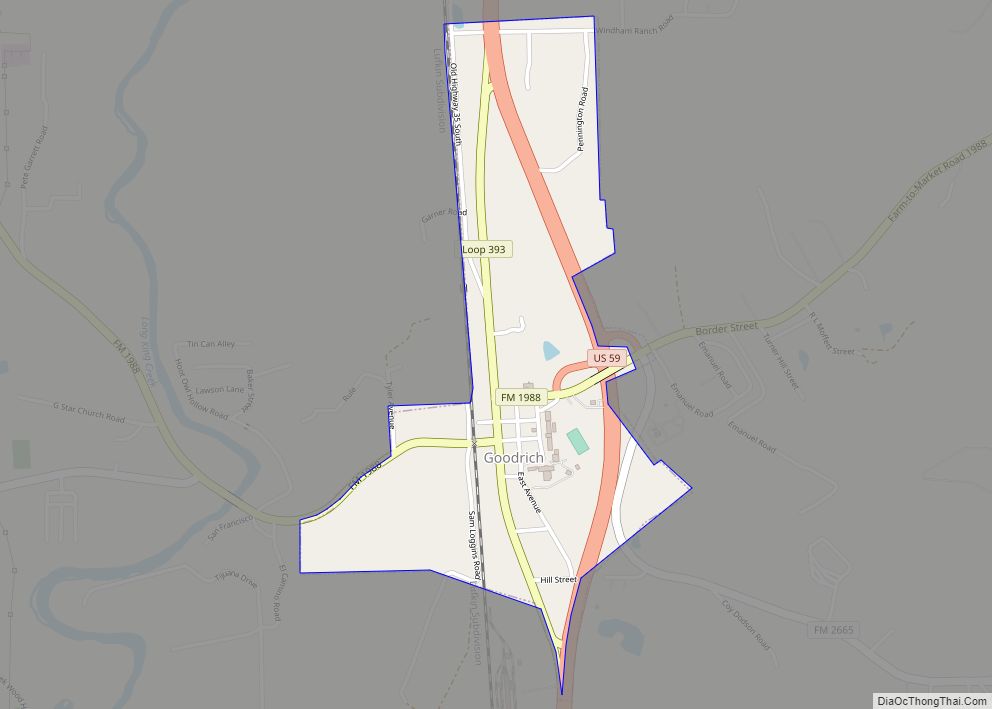
Goodrich is a city in Polk County, Texas, United States. The population was 271 at the 2010 census. Goodrich city overview: Name: Goodrich city LSAD Code: 25 LSAD Description: city (suffix) State: Texas County: Polk County Elevation: 105 ft (32 m) Total Area: 0.70 sq mi (1.83 km²) Land Area: 0.70 sq mi (1.83 km²) Water Area: 0.00 sq mi (0.00 km²) Total Population: 271 Population … Read more

Map of Goodlow city

Map of Goodlow city

Goodlow is a city in Navarro County, Texas, United States. Its population was estimated at 197 in the 2019 census. Goodlow city overview: Name: Goodlow city LSAD Code: 25 LSAD Description: city (suffix) State: Texas County: Navarro County Elevation: 341 ft (104 m) Total Area: 1.03 sq mi (2.66 km²) Land Area: 1.02 sq mi (2.65 km²) Water Area: 0.00 sq mi (0.01 km²) Total Population: … Read more

Map of Gonzales city, Texas

Map of Gonzales city, Texas

Gonzales is a city in Gonzales County, Texas, United States. It is the county seat. The population was 7,165 at the 2020 census. The “Come and Take It” flag in the War for Texas Independence from Mexico originated in Gonzales. Its economy is enhanced through lodging oil field workers from the nearby Eagle Ford Shale. … Read more

Map of Golinda city

Map of Golinda city

Golinda is a city in Falls and McLennan counties in the U.S. state of Texas. The population was 618 at the 2020 census, up from 559 at the 2010 census. The McLennan County portion of Golinda is part of the Waco Metropolitan Statistical Area. Golinda city overview: Name: Golinda city LSAD Code: 25 LSAD Description: … Read more

Map of Grays Prairie village

Map of Grays Prairie village

Grays Prairie is a village in Kaufman County, Texas, United States. The population was 337 at the 2010 census. Grays Prairie village overview: Name: Grays Prairie village LSAD Code: 47 LSAD Description: village (suffix) State: Texas County: Kaufman County Elevation: 449 ft (137 m) Total Area: 1.22 sq mi (3.17 km²) Land Area: 1.22 sq mi (3.17 km²) Water Area: 0.00 sq mi (0.00 km²) Total … Read more

Map of Grapevine city

Map of Grapevine city

Grapevine is a city located in northeast Tarrant County, Texas, United States, with minor portions extending into Dallas County and Denton County. The city is located in the Mid-Cities suburban region between Dallas and Fort Worth and includes a larger portion of Dallas/Fort Worth International Airport than other cities. The city is adjacent to Grapevine … Read more