Map of Jasper city, Texas
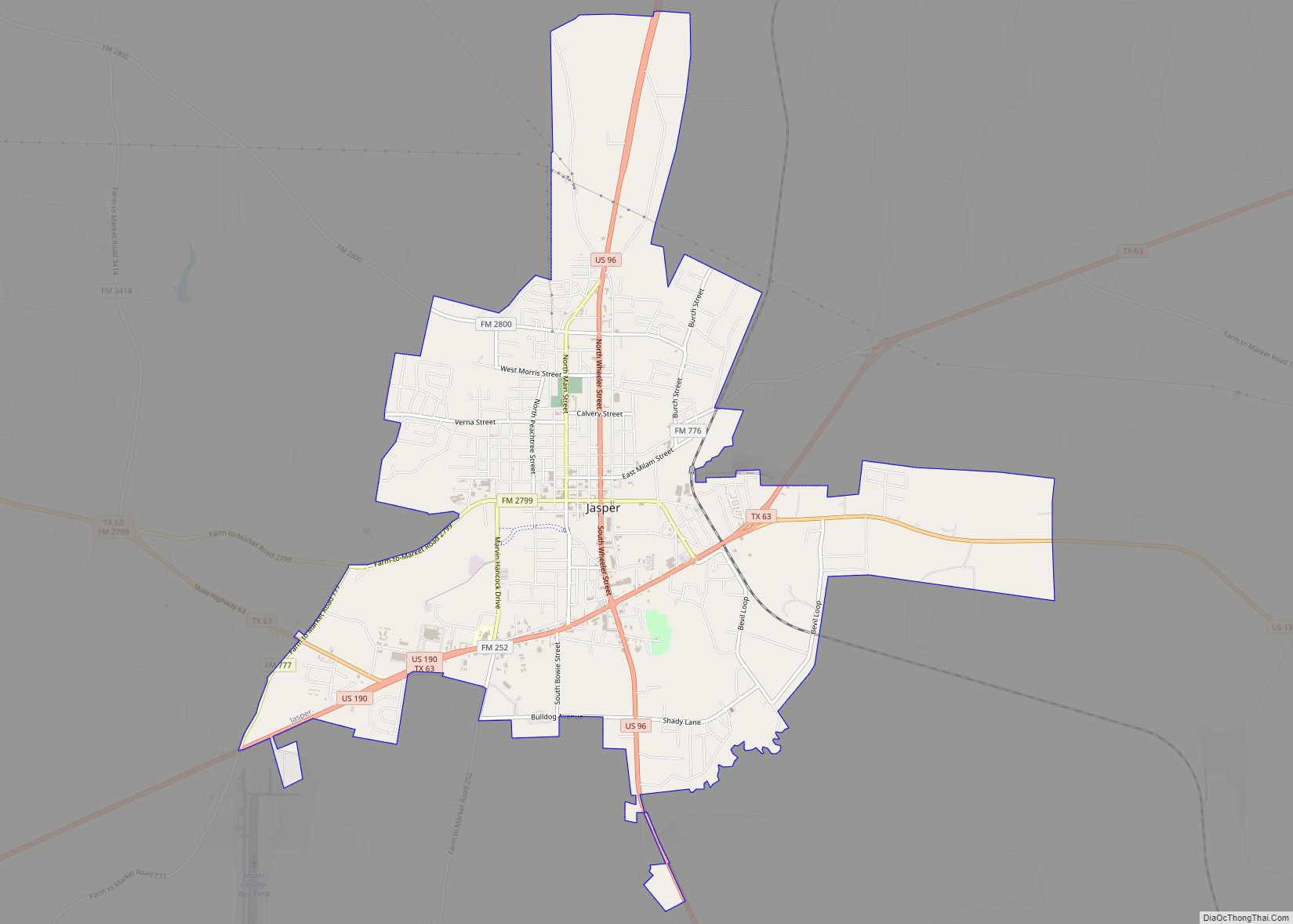
Jasper is a city in and the county seat of Jasper County, Texas, United States. Its population was 6,884 at the 2020 U.S. Census, down from 7,590 at the 2010 U.S. Census. Jasper is situated in the Deep East Texas subregion, about 40 miles (64 km) west of the Texas-Louisiana state line. Jasper (the “Butterfly Capital ... Read more
Map of Jasper city, Texas
Map of Jarrell city
Jarrell is a city in Williamson County, Texas, United States. It was incorporated as a city in 2001. The total population is 1,753 according to the 2020 census. Jarrell city overview: Name: Jarrell city LSAD Code: 25 LSAD Description: city (suffix) State: Texas County: Williamson County Elevation: 896 ft (273 m) Total Area: 2.82 sq mi (7.30 km²) Land Area: ... Read more
Map of Jarrell city
Map of Jardin de San Julian CDP
Jardin de San Julian is a census-designated place (CDP) in Starr County, Texas, United States. This was a new CDP for the 2010 census with a population of 22. Jardin de San Julian CDP overview: Name: Jardin de San Julian CDP LSAD Code: 57 LSAD Description: CDP (suffix) State: Texas County: Starr County Total Area: ... Read more
Map of Jardin de San Julian CDP
Map of Jamaica Beach city
Jamaica Beach is a city in Galveston County, Texas, United States on Galveston Island. As of the 2010 census, the city’s population was 983. the city is bordered by Galveston to the east and west, the east bay on the north and the Gulf of Mexico to the south. Jamaica Beach city overview: Name: Jamaica ... Read more
Map of Jamaica Beach city
Map of Jonestown city, Texas
Jonestown is a city in Travis County, Texas, United States on the north shore of Lake Travis. The population was 2,365 at the 2020 census. Jonestown city overview: Name: Jonestown city LSAD Code: 25 LSAD Description: city (suffix) State: Texas County: Travis County Incorporated: 1985; 38 years ago (1985) Elevation: 814 ft (248 m) Total Area: 7.60 sq mi (19.68 km²) Land ... Read more
Map of Jonestown city, Texas
Map of Jones Creek village
Jones Creek is a village in Brazoria County, Texas, United States. The population was 2,020 at the 2010 census. It is the first location in Texas where Stephen F. Austin settled. Jones Creek village overview: Name: Jones Creek village LSAD Code: 47 LSAD Description: village (suffix) State: Texas County: Brazoria County Elevation: 13 ft (4 m) Total ... Read more
Map of Jones Creek village
Map of Jolly city
Jolly is a city in Clay County, Texas, United States. It is part of the Wichita Falls, Texas Metropolitan Statistical Area. The population was 172 at the 2010 census. Jolly city overview: Name: Jolly city LSAD Code: 25 LSAD Description: city (suffix) State: Texas County: Clay County Elevation: 984 ft (300 m) Total Area: 0.99 sq mi (2.55 km²) Land ... Read more
Map of Jolly city
Map of K-Bar Ranch CDP
K-Bar Ranch is a census-designated place (CDP) in Jim Wells County, Texas, United States. The population was 358 at the 2010 census. K-Bar Ranch CDP overview: Name: K-Bar Ranch CDP LSAD Code: 57 LSAD Description: CDP (suffix) State: Texas County: Jim Wells County Elevation: 194 ft (59 m) Total Area: 3.37 sq mi (8.72 km²) Land Area: 3.37 sq mi (8.72 km²) Water ... Read more
Map of K-Bar Ranch CDP
Map of Justin city
Justin is a city in Denton County, Texas, United States. The population was 4,409 in 2020. It is also an outer ring suburb of Fort Worth. Justin city overview: Name: Justin city LSAD Code: 25 LSAD Description: city (suffix) State: Texas County: Denton County Elevation: 689 ft (210 m) Total Area: 3.27 sq mi (8.48 km²) Land Area: 3.27 sq mi (8.47 km²) ... Read more
Map of Justin city
Map of Junction city, Texas
Junction is a city in and the seat of Kimble County, Texas, United States. Its population was 2,574 at the 2010 census. Junction city overview: Name: Junction city LSAD Code: 25 LSAD Description: city (suffix) State: Texas County: Kimble County Elevation: 1,709 ft (521 m) Total Area: 2.30 sq mi (5.96 km²) Land Area: 2.29 sq mi (5.94 km²) Water Area: 0.01 sq mi (0.02 km²) ... Read more
Map of Junction city, Texas
Map of Juarez CDP
Juarez is a census-designated place (CDP) in Cameron County, in the U.S. state of Texas. The population was 1,017 at the 2010 census. Prior to the 2010 census the community was part of the Las Palmas-Juarez CDP. It is part of the Brownsville–Harlingen Metropolitan Statistical Area. Juarez CDP overview: Name: Juarez CDP LSAD Code: 57 ... Read more
Map of Juarez CDP
Map of Jourdanton city
Jourdanton (/ˈdʒɜːrdəntən/ JUR-dən-tən) is a city in and the county seat of Atascosa County, Texas, United States. The population is 4,094. It is part of the San Antonio metropolitan statistical area. The mayor is Robert “Doc” Williams. The city manager is Bobby J. Martinez. The police chief is Eric Kaiser. The fire chief is Jay ... Read more
Map of Jourdanton city