Junction is a city in and the seat of Kimble County, Texas, United States. Its population was 2,574 at the 2010 census.
| Name: | Junction city |
|---|---|
| LSAD Code: | 25 |
| LSAD Description: | city (suffix) |
| State: | Texas |
| County: | Kimble County |
| Elevation: | 1,709 ft (521 m) |
| Total Area: | 2.30 sq mi (5.96 km²) |
| Land Area: | 2.29 sq mi (5.94 km²) |
| Water Area: | 0.01 sq mi (0.02 km²) |
| Total Population: | 2,574 |
| Population Density: | 1,048.41/sq mi (404.84/km²) |
| ZIP code: | 76849 |
| Area code: | 325 |
| FIPS code: | 4838248 |
| GNISfeature ID: | 1374333 |
| Website: | cityofjunction.com |
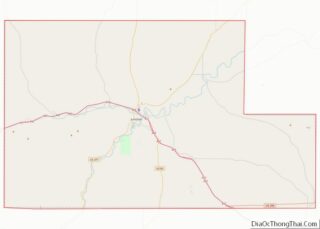
Online Interactive Map
Click on ![]() to view map in "full screen" mode.
to view map in "full screen" mode.
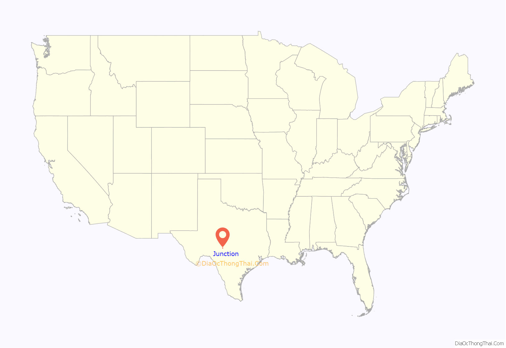
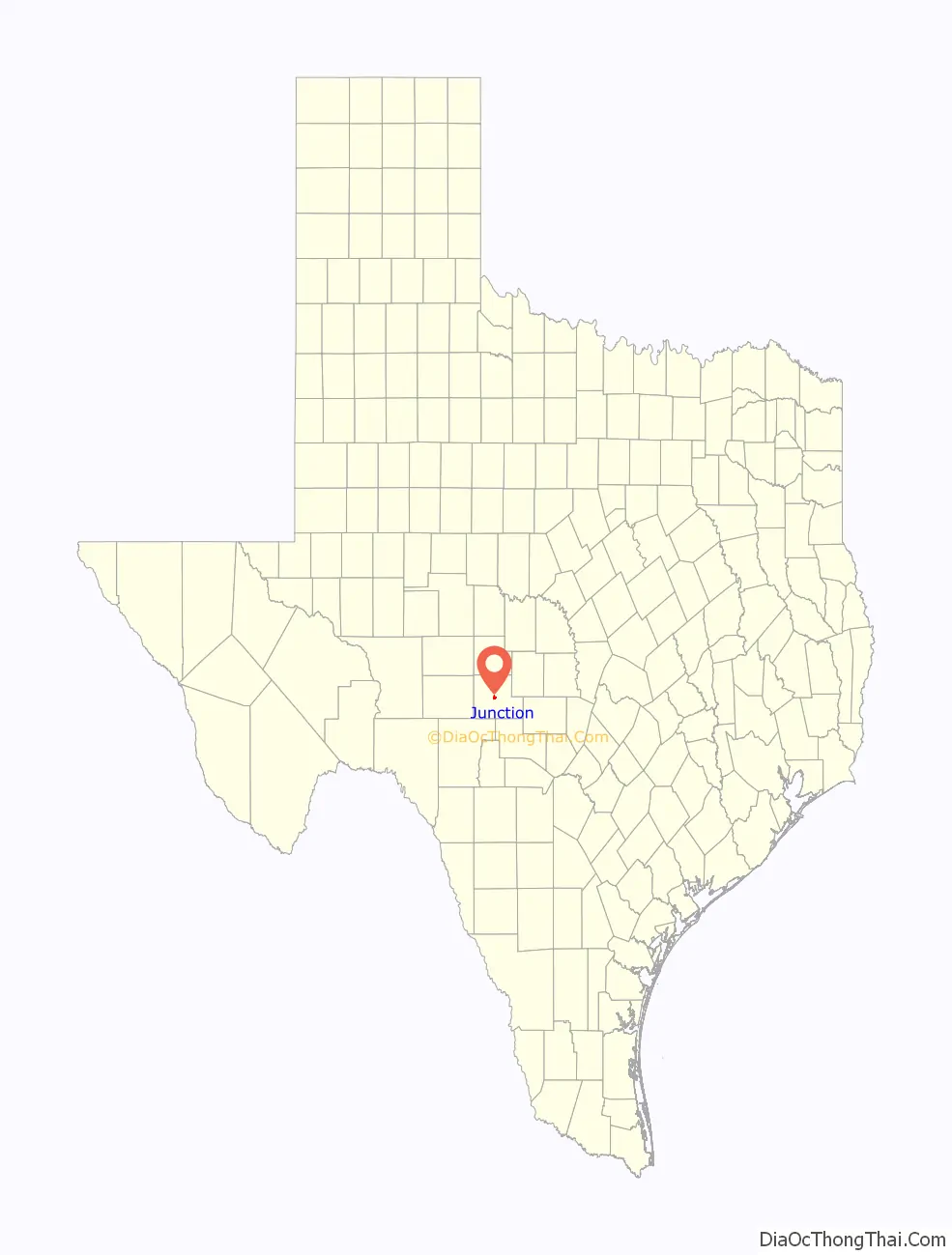
Junction location map. Where is Junction city?
History
The community was founded in 1876 after the organization of Kimble County earlier that year. The original town site was named “Denman” after Marcellus Denman, who had surveyed and platted the new community. The name was quickly changed to “Junction City”. In late 1876, Junction City won the designation of county seat from the unsuccessful and flood-prone settlement of Kimbleville. By 1879, a drugstore, livery stable, sawmill, and a few general stores were active in the community. Around 300 people were living in Junction City in 1882. The West Texas, Kimble County’s first newspaper, began publishing in 1882. The county courthouse and its records were lost to a fire in 1884. A second, two-story brick and stone courthouse was partially destroyed in an 1888 fire, but was repaired and remained in use until 1929, when the present courthouse was constructed. In 1894, Junction City became known simply as “Junction”. Infrastructure improvements marked the decade of the 1890s. Businessman Ernest Holekamp provided the city’s first waterworks with a canal dug from the South Llano to Junction in 1895. A dam was built in 1896 on the South Llano River to provide power and water to the city and irrigation to surrounding lands.
The population stood at 536 in 1900. Four Mile Dam, a more permanent and extensive dam, was completed in 1904. Junction continued to grow rapidly, with around 800 residents living in the community in 1910. That figure had grown to 1,250 by 1920. By the late 1920s, citizens felt the need for the benefits of a municipal government. On August 27, 1927, H.O. Denman and 152 others presented an incorporation petition to Kimble County Judge J.B. Randolph. In the election, 390 votes were cast: 274 (70%) “For Incorporation” and 116 (30%) “Against Incorporation”. A city officers’ election took place on October 13, 1927, with Ernest Holekamp elected as Junction’s first mayor.
During the mid-1920s, highway connections from Junction to Menard and San Angelo were made available. A sewer system was built in 1929. In the 1930 census, the city recorded 1,415 residents. Junction was the chief shipping and commercial center of Kimble County, as well as a tourist resort and hunting center. A new municipal building and fire station were opened in 1939 and 1940, respectively. In the mid-1940s, the cedar-oil business enhanced the economy, but the city’s growth slowed. Throughout the latter half of the 20th century and into the 21st, Junction’s population continued to hover around 2,600.
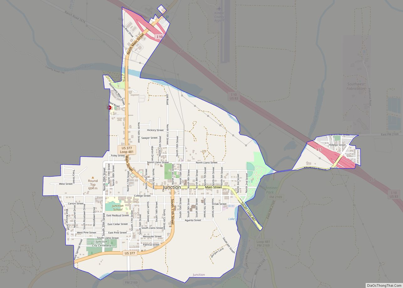
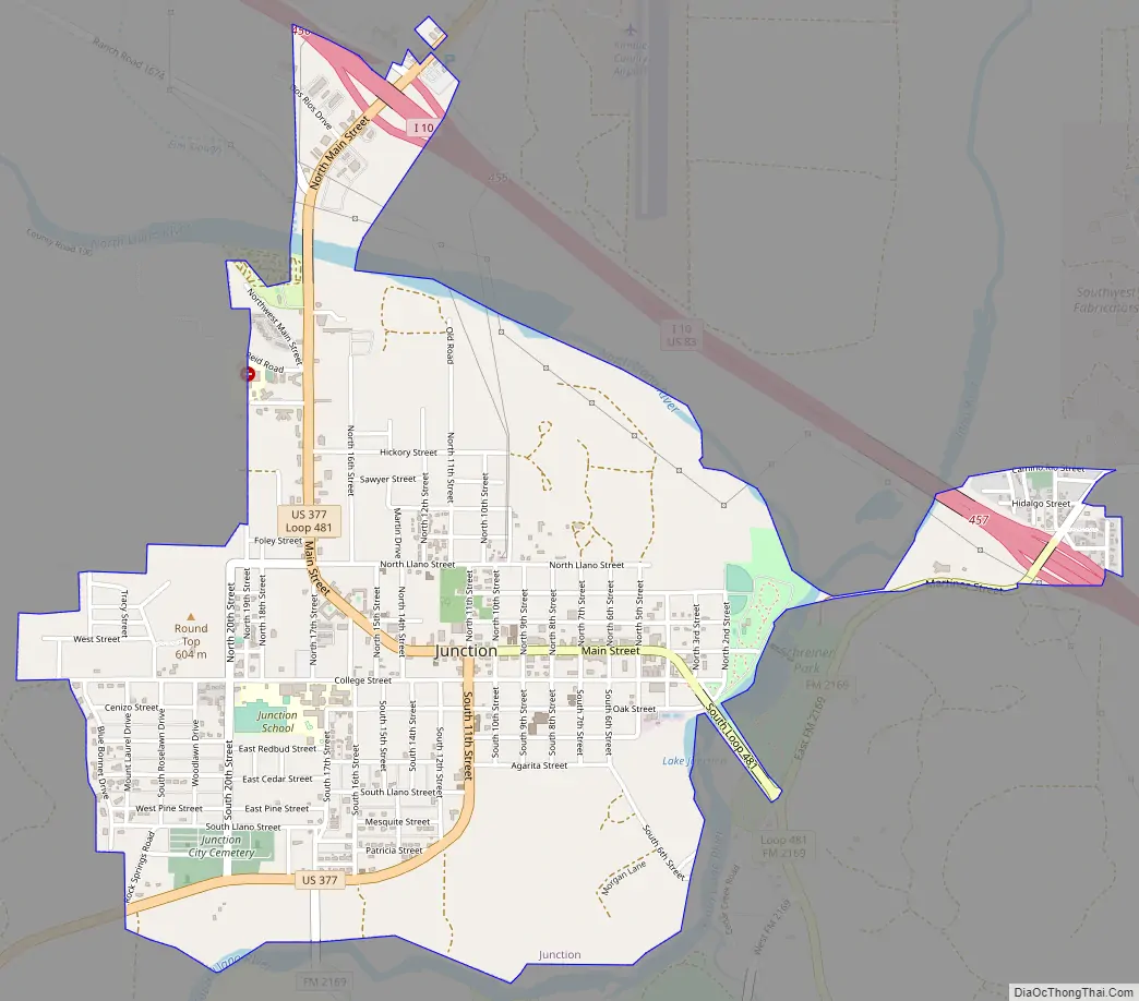
Junction Road Map
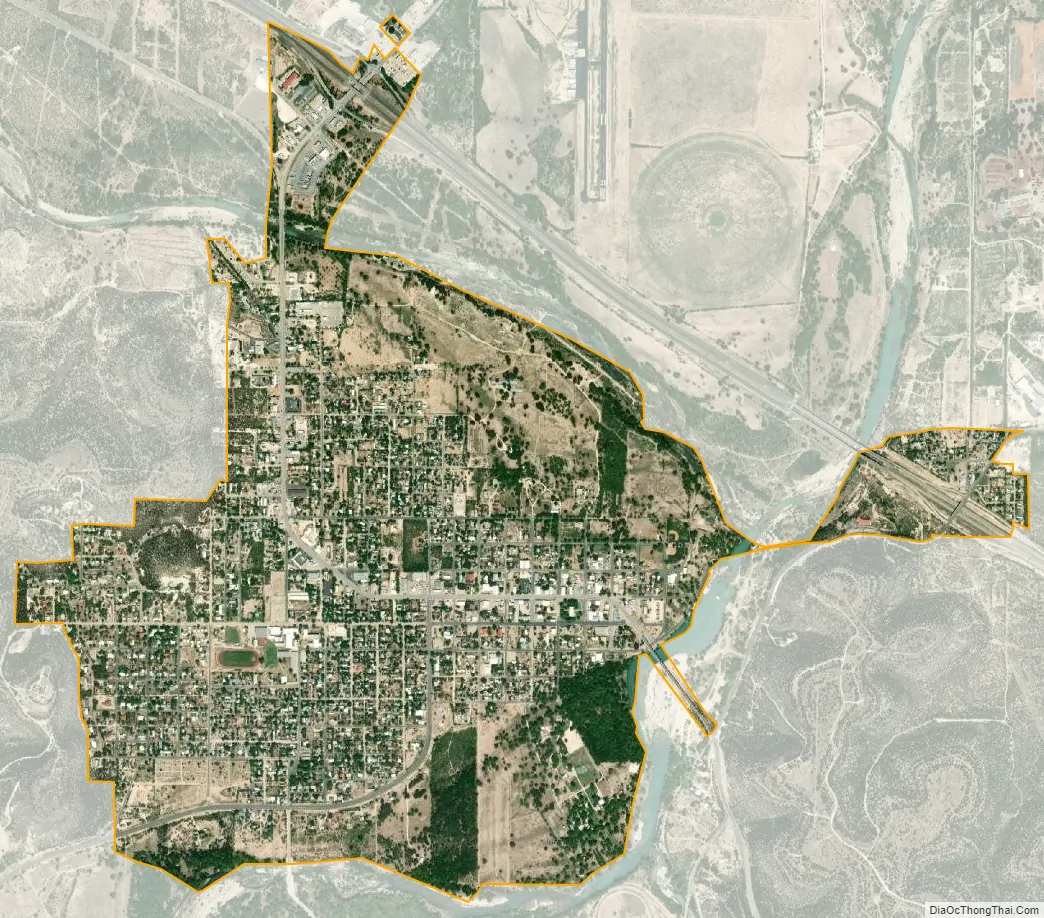
Junction city Satellite Map
Geography
Junction is located at 30°29′23″N 99°46′17″W / 30.489772°N 99.771335°W / 30.489772; -99.771335 (30.489772, –99.771335), about 115 miles (185 km) northwest of San Antonio and 140 miles (230 km) west of Austin in central Kimble County. Interstate 10 runs through the northern and eastern parts of the city, with access from Exits 456 and 457. I-10 leads southeast 52 miles (84 km) to Kerrville and beyond to San Antonio, and west 57 miles (92 km) to Sonora. U.S. Route 83 follows I-10 past Junction, leading north 31 miles (50 km) to Menard and south 102 miles (164 km) to Uvalde. U.S. Route 377 passes through the center of Junction as Main Street and 11th Street. To the northeast, U.S. 377 leads 45 miles (72 km) to Mason, and to the southwest it leads 46 miles (74 km) to Rocksprings.
According to the United States Census Bureau, Junction has a total area of 2.3 sq mi (6.0 km), of which 0.01 square miles (0.02 km), or 0.26%, is covered by water. The city is named for its location at the confluence of the North and South Llano Rivers.
See also
Map of Texas State and its subdivision:- Anderson
- Andrews
- Angelina
- Aransas
- Archer
- Armstrong
- Atascosa
- Austin
- Bailey
- Bandera
- Bastrop
- Baylor
- Bee
- Bell
- Bexar
- Blanco
- Borden
- Bosque
- Bowie
- Brazoria
- Brazos
- Brewster
- Briscoe
- Brooks
- Brown
- Burleson
- Burnet
- Caldwell
- Calhoun
- Callahan
- Cameron
- Camp
- Carson
- Cass
- Castro
- Chambers
- Cherokee
- Childress
- Clay
- Cochran
- Coke
- Coleman
- Collin
- Collingsworth
- Colorado
- Comal
- Comanche
- Concho
- Cooke
- Coryell
- Cottle
- Crane
- Crockett
- Crosby
- Culberson
- Dallam
- Dallas
- Dawson
- Deaf Smith
- Delta
- Denton
- Dewitt
- Dickens
- Dimmit
- Donley
- Duval
- Eastland
- Ector
- Edwards
- El Paso
- Ellis
- Erath
- Falls
- Fannin
- Fayette
- Fisher
- Floyd
- Foard
- Fort Bend
- Franklin
- Freestone
- Frio
- Gaines
- Galveston
- Garza
- Gillespie
- Glasscock
- Goliad
- Gonzales
- Gray
- Grayson
- Gregg
- Grimes
- Guadalupe
- Hale
- Hall
- Hamilton
- Hansford
- Hardeman
- Hardin
- Harris
- Harrison
- Hartley
- Haskell
- Hays
- Hemphill
- Henderson
- Hidalgo
- Hill
- Hockley
- Hood
- Hopkins
- Houston
- Howard
- Hudspeth
- Hunt
- Hutchinson
- Irion
- Jack
- Jackson
- Jasper
- Jeff Davis
- Jefferson
- Jim Hogg
- Jim Wells
- Johnson
- Jones
- Karnes
- Kaufman
- Kendall
- Kenedy
- Kent
- Kerr
- Kimble
- King
- Kinney
- Kleberg
- Knox
- La Salle
- Lamar
- Lamb
- Lampasas
- Lavaca
- Lee
- Leon
- Liberty
- Limestone
- Lipscomb
- Live Oak
- Llano
- Loving
- Lubbock
- Lynn
- Madison
- Marion
- Martin
- Mason
- Matagorda
- Maverick
- McCulloch
- McLennan
- McMullen
- Medina
- Menard
- Midland
- Milam
- Mills
- Mitchell
- Montague
- Montgomery
- Moore
- Morris
- Motley
- Nacogdoches
- Navarro
- Newton
- Nolan
- Nueces
- Ochiltree
- Oldham
- Orange
- Palo Pinto
- Panola
- Parker
- Parmer
- Pecos
- Polk
- Potter
- Presidio
- Rains
- Randall
- Reagan
- Real
- Red River
- Reeves
- Refugio
- Roberts
- Robertson
- Rockwall
- Runnels
- Rusk
- Sabine
- San Augustine
- San Jacinto
- San Patricio
- San Saba
- Schleicher
- Scurry
- Shackelford
- Shelby
- Sherman
- Smith
- Somervell
- Starr
- Stephens
- Sterling
- Stonewall
- Sutton
- Swisher
- Tarrant
- Taylor
- Terrell
- Terry
- Throckmorton
- Titus
- Tom Green
- Travis
- Trinity
- Tyler
- Upshur
- Upton
- Uvalde
- Val Verde
- Van Zandt
- Victoria
- Walker
- Waller
- Ward
- Washington
- Webb
- Wharton
- Wheeler
- Wichita
- Wilbarger
- Willacy
- Williamson
- Wilson
- Winkler
- Wise
- Wood
- Yoakum
- Young
- Zapata
- Zavala
- Alabama
- Alaska
- Arizona
- Arkansas
- California
- Colorado
- Connecticut
- Delaware
- District of Columbia
- Florida
- Georgia
- Hawaii
- Idaho
- Illinois
- Indiana
- Iowa
- Kansas
- Kentucky
- Louisiana
- Maine
- Maryland
- Massachusetts
- Michigan
- Minnesota
- Mississippi
- Missouri
- Montana
- Nebraska
- Nevada
- New Hampshire
- New Jersey
- New Mexico
- New York
- North Carolina
- North Dakota
- Ohio
- Oklahoma
- Oregon
- Pennsylvania
- Rhode Island
- South Carolina
- South Dakota
- Tennessee
- Texas
- Utah
- Vermont
- Virginia
- Washington
- West Virginia
- Wisconsin
- Wyoming