Map of Mobeetie city
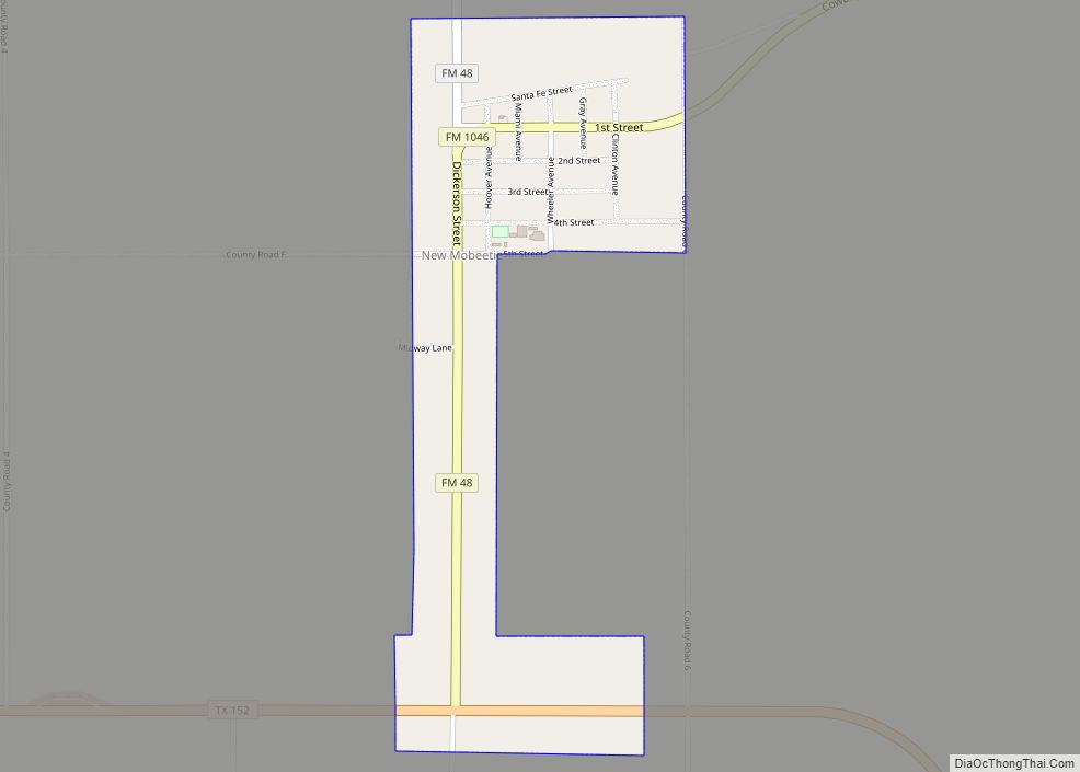
Mobeetie is a city in northwestern Wheeler County, Texas, United States, located on Sweetwater Creek and State Highway 152. Its population was 101 at the 2010 census, six below the 2000 figure. Mobeetie city overview: Name: Mobeetie city LSAD Code: 25 LSAD Description: city (suffix) State: Texas County: Wheeler County Elevation: 2,641 ft (805 m) Total Area: ... Read more
Map of Mobeetie city
Map of Missouri City, Texas
Missouri City is a city in the U.S. state of Texas, within the Houston–The Woodlands–Sugar Land metropolitan area. The city is mostly in Fort Bend County, with a small portion in Harris County. As of the 2020 census, the city had a population of 74,259, up from 67,358 in 2010. The population was estimated at 75,457 in ... Read more
Map of Missouri City, Texas
Map of Mission city, Texas
Mission is a city in Hidalgo County, Texas, United States. Its population was 77,058 at the 2010 census and an estimated 84,331 in 2019. Mission is part of the McAllen–Edinburg–Mission and Reynosa–McAllen metropolitan areas. Mission city overview: Name: Mission city LSAD Code: 25 LSAD Description: city (suffix) State: Texas County: Hidalgo County Incorporated: 1910 Elevation: ... Read more
Map of Mission city, Texas
Map of Mission Bend CDP
Mission Bend is a census-designated place (CDP) around Texas State Highway 6 within the extraterritorial jurisdiction of Houston in Fort Bend and Harris counties in the U.S. state of Texas; Mission Bend is 4 miles (6 km) northwest of the city hall of Sugar Land and 20 miles (32 km) southwest of Downtown Houston. The population was ... Read more
Map of Mission Bend CDP
Map of Mirando City CDP
Mirando City is a census-designated place (CDP) in Webb County, Texas, United States. It is three hundred eighty-four miles southwest of Houston. The population was 166 at the 2010 census. The town gets its name from Nicolás Mirando, a Spanish land grantee. The population of Mirando City was highest in 1929, at an estimated 1500. ... Read more
Map of Mirando City CDP
Map of Mingus city
Mingus is a city in Palo Pinto County, Texas, United States. The population was 235 at the 2010 census. Mingus city overview: Name: Mingus city LSAD Code: 25 LSAD Description: city (suffix) State: Texas County: Palo Pinto County Elevation: 951 ft (290 m) Total Area: 1.55 sq mi (4.01 km²) Land Area: 1.55 sq mi (4.01 km²) Water Area: 0.00 sq mi (0.00 km²) Total Population: ... Read more
Map of Mingus city
Map of Monte Alto CDP
Monte Alto is a census-designated place (CDP) in Hidalgo County, Texas. The population was 1,924 at the 2010 census, up from 1,611 in 2000. It is part of the McAllen–Edinburg–Mission Metropolitan Statistical Area. Monte Alto CDP overview: Name: Monte Alto CDP LSAD Code: 57 LSAD Description: CDP (suffix) State: Texas County: Hidalgo County Elevation: 52 ft ... Read more
Map of Monte Alto CDP
Map of Morgan’s Point city
Morgan’s Point is located 30 miles Southeast of Houston in Southeast Harris County, Texas, United States, located on the shores of Galveston Bay at the inlet to the Houston Ship Channel, near La Porte and Baytown. As of the 2010 census, it had a population of 339. As of 2020, it has approximately 356 residents ... Read more
Map of Morgan’s Point city
Map of Morgan’s Point Resort city
Morgan’s Point Resort is a General Law city in Bell County, Texas, United States.Morgan’s Point Resort was incorporated 1970. Per 2020 census the population was 4,636. It is part of the Killeen–Temple–Fort Hood Metropolitan Statistical Area. Morgan’s Point Resort city overview: Name: Morgan’s Point Resort city LSAD Code: 25 LSAD Description: city (suffix) State: Texas ... Read more
Map of Morgan’s Point Resort city
Map of Moran city, Texas
Moran is a city in southeast Shackelford County, Texas, United States. The population was 270 at the 2010 census. Moran city overview: Name: Moran city LSAD Code: 25 LSAD Description: city (suffix) State: Texas County: Shackelford County Elevation: 1,358 ft (414 m) Total Area: 0.42 sq mi (1.10 km²) Land Area: 0.42 sq mi (1.10 km²) Water Area: 0.00 sq mi (0.00 km²) Total Population: 270 ... Read more
Map of Moran city, Texas
Map of Morales-Sanchez CDP
Morales-Sanchez is a census-designated place (CDP) in Zapata County, Texas, United States. The population was 84 at the 2010 census. Morales-Sanchez CDP overview: Name: Morales-Sanchez CDP LSAD Code: 57 LSAD Description: CDP (suffix) State: Texas County: Zapata County Total Area: 1.4 sq mi (4 km²) Land Area: 1.4 sq mi (4 km²) Water Area: 0.0 sq mi (0 km²) Total Population: 84 Population Density: ... Read more
Map of Morales-Sanchez CDP
Map of Moraida CDP
Moraida is a census-designated place (CDP) in Starr County, Texas, United States. It is a new CDP formed from part of the North Escobares CDP prior to the 2010 census with a population of 212. Moraida CDP overview: Name: Moraida CDP LSAD Code: 57 LSAD Description: CDP (suffix) State: Texas County: Starr County Total Area: ... Read more
Map of Moraida CDP