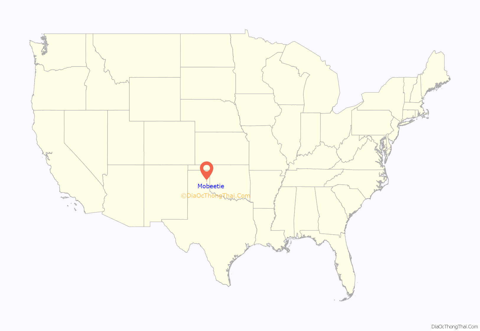
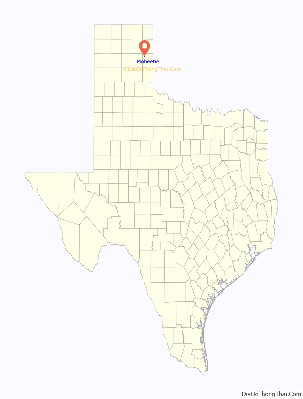
Mobeetie is a city in northwestern Wheeler County, Texas, United States, located on Sweetwater Creek and State Highway 152. Its population was 101 at the 2010 census, six below the 2000 figure.
| Name: | Mobeetie city |
|---|---|
| LSAD Code: | 25 |
| LSAD Description: | city (suffix) |
| State: | Texas |
| County: | Wheeler County |
| Elevation: | 2,641 ft (805 m) |
| Total Area: | 0.61 sq mi (1.58 km²) |
| Land Area: | 0.61 sq mi (1.58 km²) |
| Water Area: | 0.00 sq mi (0.00 km²) |
| Total Population: | 101 |
| Population Density: | 155.74/sq mi (60.09/km²) |
| ZIP code: | 79061 |
| Area code: | 806 |
| FIPS code: | 4848852 |
| GNISfeature ID: | 1363014 |
Online Interactive Map
Click on ![]() to view map in "full screen" mode.
to view map in "full screen" mode.
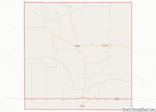
Mobeetie location map. Where is Mobeetie city?
History
Mobeetie (formerly known as “Cantonment Sweetwater”) was a trading post for hunters and trappers for nearby United States Army outpost Fort Elliott. It was first a buffalo hunters’ camp unofficially called “Hidetown”. Connected to the major cattle-drive town of Dodge City, Kansas, by the Jones-Plummer Trail, Mobeetie was a destination for stagecoach freight and buffalo skinners. As it grew, the town supported the development of cattle ranches within a hundred-mile radius by supplying the staple crops.
The first formal name for the town was “Sweetwater”. It was located on the North Fork Red River, a tributary of the Red River of the South. Nearby Fort Elliott, developed to protect the buffalo trade from Indian raiders, stimulated further growth of the town. On January 24, 1876, the “Sweetwater Shootout” occurred. Anthony Cook (Corporal “Sergeant” Melvin A. King; of the then-4th Cavalry Company H, stationed at Fort Elliot) shot and killed Mollie Brennan (a dancehall girl and former prostitute). Sgt. King then wounded Bat Masterson, who in turn killed him (King may have shot Masterson first and then killed Brennan; accounts vary). Texas cattleman Charles Goodnight said about the town: “I think it was the hardest place I ever saw on the frontier except Cheyenne, Wyoming.”
When the town applied for a post office in 1879, the name “Sweetwater” was already in use. The town took the new name of “Mobeetie”, believed to be a Native American word for Sweetwater. It was allegedly later revealed that the word, in fact, meant “buffalo dung.”
Because of the presence of Fort Elliott and Mobeetie’s importance as a commercial center, Wheeler County became the first politically organized county in the Texas Panhandle, in 1879, followed by Oldham County at Tascosa, now a ghost town. Mobeetie became the first county seat for Wheeler County. From 1880 to 1883, the notorious Robert Clay Allison ranched with his two brothers, John William and Jeremiah Monroe, 12 miles northeast of town, at the junction of the Washita River and Gageby Creek. One day, Allison rode through Mobeetie drunk and naked. Allison married America Medora “Dora” McCulloch in Mobeetie on February 15, 1881.
At its peak in 1890, the town had over 400 people, but Mobeetie’s boom days ended when Fort Elliott closed that same year. Further decline came with the tornado of May 1, 1898, and then the loss of the county seat, in 1907, to Wheeler. In 1929, Mobeetie moved two miles when the Panhandle and Santa Fe Railway built nearby tracks. The town steadily grew again until the start of World War II brought a peak around 500.
Mobeetie is also known as the birthplace of a member of the 1919 World Series champion Cincinnati Reds infielder and catcher Morrie Rath. Rath was born on Christmas Day 1886.
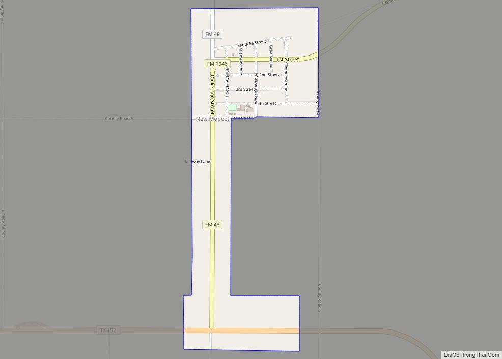
Mobeetie Road Map
Mobeetie city Satellite Map

Geography
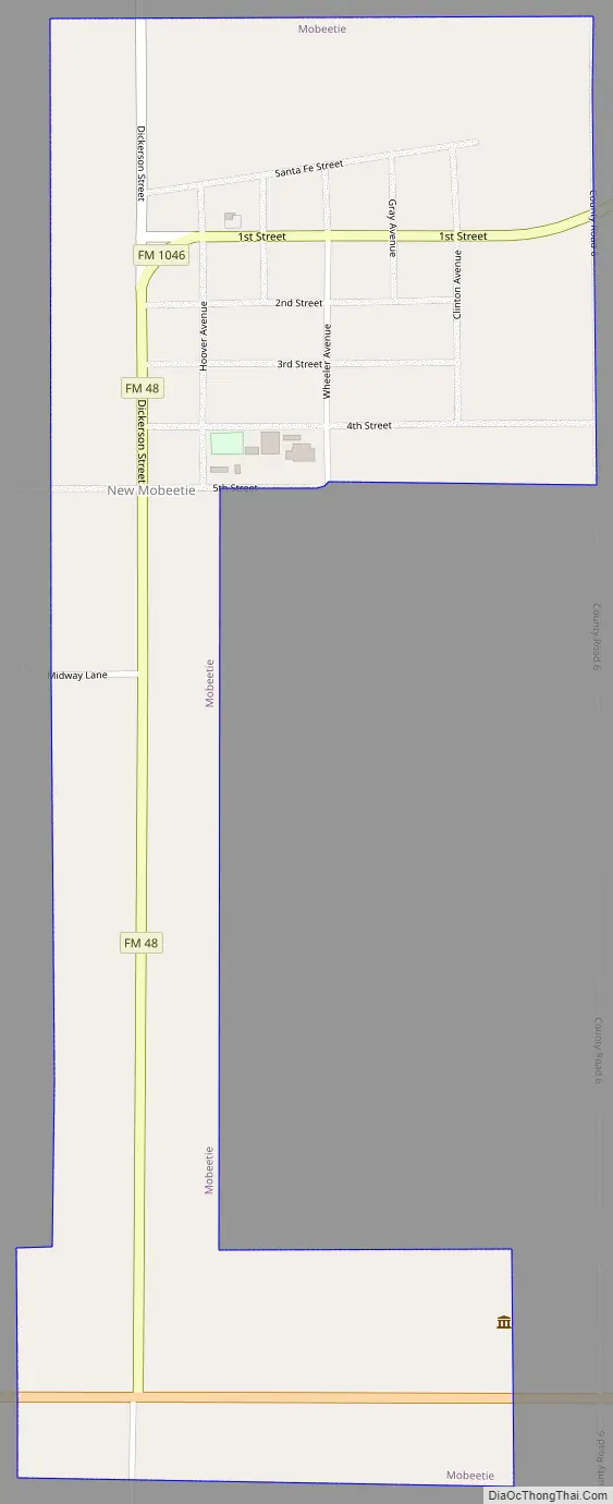
Mobeetie is located in the Texas Panhandle northeast of Sweetwater Creek along Texas State Highway 152, Farm to Market Road 48, and Farm to Market Road 1046. Pampa lies about 30 miles to the west, and Wheeler is about 10 miles to the east along route 152. The Fort Elliot historical site is about one mile west along SH 152.
According to the United States Census Bureau, the city has a total area of 0.6 sq mi (1.6 km), all land.
See also
Map of Texas State and its subdivision:- Anderson
- Andrews
- Angelina
- Aransas
- Archer
- Armstrong
- Atascosa
- Austin
- Bailey
- Bandera
- Bastrop
- Baylor
- Bee
- Bell
- Bexar
- Blanco
- Borden
- Bosque
- Bowie
- Brazoria
- Brazos
- Brewster
- Briscoe
- Brooks
- Brown
- Burleson
- Burnet
- Caldwell
- Calhoun
- Callahan
- Cameron
- Camp
- Carson
- Cass
- Castro
- Chambers
- Cherokee
- Childress
- Clay
- Cochran
- Coke
- Coleman
- Collin
- Collingsworth
- Colorado
- Comal
- Comanche
- Concho
- Cooke
- Coryell
- Cottle
- Crane
- Crockett
- Crosby
- Culberson
- Dallam
- Dallas
- Dawson
- Deaf Smith
- Delta
- Denton
- Dewitt
- Dickens
- Dimmit
- Donley
- Duval
- Eastland
- Ector
- Edwards
- El Paso
- Ellis
- Erath
- Falls
- Fannin
- Fayette
- Fisher
- Floyd
- Foard
- Fort Bend
- Franklin
- Freestone
- Frio
- Gaines
- Galveston
- Garza
- Gillespie
- Glasscock
- Goliad
- Gonzales
- Gray
- Grayson
- Gregg
- Grimes
- Guadalupe
- Hale
- Hall
- Hamilton
- Hansford
- Hardeman
- Hardin
- Harris
- Harrison
- Hartley
- Haskell
- Hays
- Hemphill
- Henderson
- Hidalgo
- Hill
- Hockley
- Hood
- Hopkins
- Houston
- Howard
- Hudspeth
- Hunt
- Hutchinson
- Irion
- Jack
- Jackson
- Jasper
- Jeff Davis
- Jefferson
- Jim Hogg
- Jim Wells
- Johnson
- Jones
- Karnes
- Kaufman
- Kendall
- Kenedy
- Kent
- Kerr
- Kimble
- King
- Kinney
- Kleberg
- Knox
- La Salle
- Lamar
- Lamb
- Lampasas
- Lavaca
- Lee
- Leon
- Liberty
- Limestone
- Lipscomb
- Live Oak
- Llano
- Loving
- Lubbock
- Lynn
- Madison
- Marion
- Martin
- Mason
- Matagorda
- Maverick
- McCulloch
- McLennan
- McMullen
- Medina
- Menard
- Midland
- Milam
- Mills
- Mitchell
- Montague
- Montgomery
- Moore
- Morris
- Motley
- Nacogdoches
- Navarro
- Newton
- Nolan
- Nueces
- Ochiltree
- Oldham
- Orange
- Palo Pinto
- Panola
- Parker
- Parmer
- Pecos
- Polk
- Potter
- Presidio
- Rains
- Randall
- Reagan
- Real
- Red River
- Reeves
- Refugio
- Roberts
- Robertson
- Rockwall
- Runnels
- Rusk
- Sabine
- San Augustine
- San Jacinto
- San Patricio
- San Saba
- Schleicher
- Scurry
- Shackelford
- Shelby
- Sherman
- Smith
- Somervell
- Starr
- Stephens
- Sterling
- Stonewall
- Sutton
- Swisher
- Tarrant
- Taylor
- Terrell
- Terry
- Throckmorton
- Titus
- Tom Green
- Travis
- Trinity
- Tyler
- Upshur
- Upton
- Uvalde
- Val Verde
- Van Zandt
- Victoria
- Walker
- Waller
- Ward
- Washington
- Webb
- Wharton
- Wheeler
- Wichita
- Wilbarger
- Willacy
- Williamson
- Wilson
- Winkler
- Wise
- Wood
- Yoakum
- Young
- Zapata
- Zavala
- Alabama
- Alaska
- Arizona
- Arkansas
- California
- Colorado
- Connecticut
- Delaware
- District of Columbia
- Florida
- Georgia
- Hawaii
- Idaho
- Illinois
- Indiana
- Iowa
- Kansas
- Kentucky
- Louisiana
- Maine
- Maryland
- Massachusetts
- Michigan
- Minnesota
- Mississippi
- Missouri
- Montana
- Nebraska
- Nevada
- New Hampshire
- New Jersey
- New Mexico
- New York
- North Carolina
- North Dakota
- Ohio
- Oklahoma
- Oregon
- Pennsylvania
- Rhode Island
- South Carolina
- South Dakota
- Tennessee
- Texas
- Utah
- Vermont
- Virginia
- Washington
- West Virginia
- Wisconsin
- Wyoming