Map of Moore Station city

Map of Moore Station city

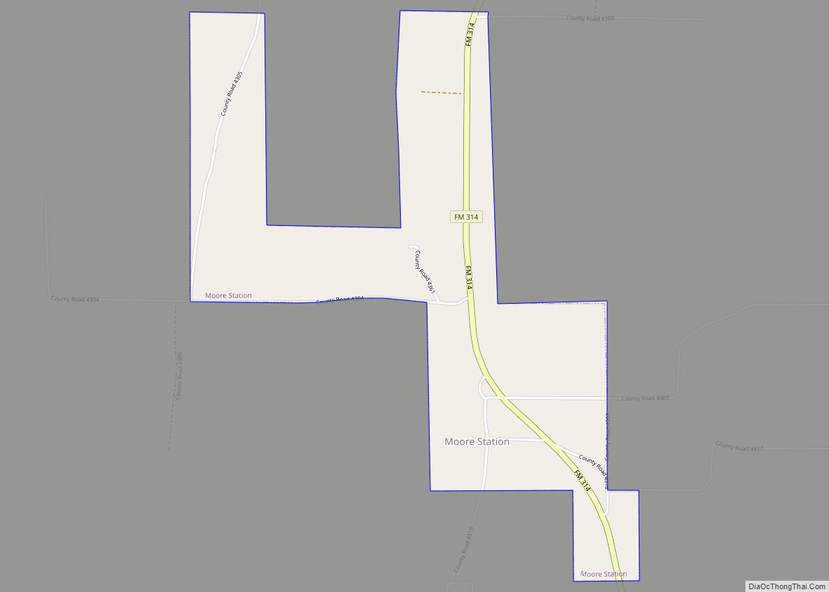
Moore Station is a city in Henderson County, Texas, United States. The population was 160 at the 2020 census. It was founded in 1876 by Anderson Moore, a former “mulatto” slave. Moore Station city overview: Name: Moore Station city LSAD Code: 25 LSAD Description: city (suffix) State: Texas County: Henderson County Elevation: 420 ft (130 m) Total … Read more

Map of Moody city, Texas

Map of Moody city, Texas

Moody is a city in McLennan County, Texas, United States. The population was 1,376 at the 2020 census. It is part of the Waco Metropolitan Statistical Area. Moody city overview: Name: Moody city LSAD Code: 25 LSAD Description: city (suffix) State: Texas County: McLennan County Elevation: 781 ft (238 m) Total Area: 0.96 sq mi (2.49 km²) Land Area: 0.96 sq mi … Read more

Map of Montgomery city, Texas

Map of Montgomery city, Texas

Montgomery is a city located in Montgomery County, Texas. As of the 2020 census, the city had a total population of 1,948. Montgomery city overview: Name: Montgomery city LSAD Code: 25 LSAD Description: city (suffix) State: Texas County: Montgomery County Incorporated: February 26, 1848 Elevation: 295 ft (90 m) Total Area: 5.12 sq mi (13.26 km²) Land Area: 5.04 sq mi (13.05 km²) … Read more

Map of Monte Alto CDP

Map of Monte Alto CDP

Monte Alto is a census-designated place (CDP) in Hidalgo County, Texas. The population was 1,924 at the 2010 census, up from 1,611 in 2000. It is part of the McAllen–Edinburg–Mission Metropolitan Statistical Area. Monte Alto CDP overview: Name: Monte Alto CDP LSAD Code: 57 LSAD Description: CDP (suffix) State: Texas County: Hidalgo County Elevation: 52 ft … Read more

Map of Morgan Farm CDP

Map of Morgan Farm CDP

Morgan Farm is a census-designated place (CDP) in San Patricio County, Texas, United States. The population was 463 at the 2010 census. Prior to the 2010 census Morgan Farm CDP was known as Morgan Farm Area CDP. Morgan Farm CDP overview: Name: Morgan Farm CDP LSAD Code: 57 LSAD Description: CDP (suffix) State: Texas County: … Read more

Map of Mount Vernon town, Texas

Map of Mount Vernon town, Texas

Mount Vernon is a town and the county seat of Franklin County, Texas, United States. The population was 2,491 at the 2020 United States census. Mount Vernon town overview: Name: Mount Vernon town LSAD Code: 43 LSAD Description: town (suffix) State: Texas County: Franklin County Elevation: 492 ft (150 m) Total Area: 4.40 sq mi (11.40 km²) Land Area: 4.31 sq mi … Read more

Map of Mount Pleasant city, Texas

Map of Mount Pleasant city, Texas

Mount Pleasant is the county seat of and largest city in Titus County, in the U.S. state of Texas. As of the 2020 census, Mount Pleasant’s population was 16,047; it is situated in Northeast Texas. Mount Pleasant city overview: Name: Mount Pleasant city LSAD Code: 25 LSAD Description: city (suffix) State: Texas County: Titus County … Read more

Map of Mount Enterprise city

Map of Mount Enterprise city

Mount Enterprise is a city in Rusk County, Texas, United States. The population was 447 at the 2010 census. Mount Enterprise city overview: Name: Mount Enterprise city LSAD Code: 25 LSAD Description: city (suffix) State: Texas County: Rusk County Elevation: 479 ft (146 m) Total Area: 1.49 sq mi (3.85 km²) Land Area: 1.49 sq mi (3.85 km²) Water Area: 0.00 sq mi (0.00 km²) Total … Read more

Map of Mount Calm city

Map of Mount Calm city

Mount Calm is a town in Hill County, Texas, United States. The population was 320 at the 2010 census. Mount Calm city overview: Name: Mount Calm city LSAD Code: 25 LSAD Description: city (suffix) State: Texas County: Hill County Elevation: 604 ft (184 m) Total Area: 0.84 sq mi (2.17 km²) Land Area: 0.82 sq mi (2.13 km²) Water Area: 0.01 sq mi (0.04 km²) Total … Read more

Map of Moulton town, Texas

Map of Moulton town, Texas

Moulton is a town in Lavaca County, Texas, United States. The population was 854 at the 2020 census. Moulton town overview: Name: Moulton town LSAD Code: 43 LSAD Description: town (suffix) State: Texas County: Lavaca County Elevation: 361 ft (110 m) Total Area: 0.83 sq mi (2.16 km²) Land Area: 0.83 sq mi (2.16 km²) Water Area: 0.00 sq mi (0.00 km²) Total Population: 854 Population … Read more

Map of Morton city, Texas

Map of Morton city, Texas

Morton is a city and county seat of Cochran County, Texas, United States. As of the 2010 census, the city population was 2,006. This represented a 10.8% population decline since the 2000 Census. Morton city overview: Name: Morton city LSAD Code: 25 LSAD Description: city (suffix) State: Texas County: Cochran County Elevation: 3,760 ft (1,146 m) Total … Read more

Map of Morse CDP, Texas

Map of Morse CDP, Texas

Morse is an unincorporated community and census-designated place (CDP) in Hansford County, Texas, United States. The population was 147 at the 2010 census, down from 172 at the 2000 census. Morse CDP overview: Name: Morse CDP LSAD Code: 57 LSAD Description: CDP (suffix) State: Texas County: Hansford County Elevation: 3,205 ft (977 m) Total Area: 0.5 sq mi (1.4 km²) … Read more