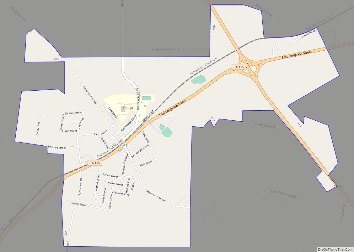
Map of Arcola city, Texas

Map of Arcola city, Texas

Arcola is a city in Fort Bend County, Texas, United States, within the Houston–Sugar Land–Baytown metropolitan area. The population was 2,034 as of the 2020 census, up from 1,642 at the 2010 census, up from 1,048 at the 2000 census. Arcola incorporated in 1986. Arcola city overview: Name: Arcola city LSAD Code: 25 LSAD Description: city … Read more

Map of Archer City city

Map of Archer City

Archer City is a city in and the county seat of Archer County, Texas, United States. The city lies at the junction of State Highway 79 and State Highway 25. It is located 25 miles (40 km) south of Wichita Falls, and is part of the Wichita Falls metropolitan statistical area. Its population was 1,834 at … Read more

Map of Aurora city, Texas

Map of Aurora city, Texas

Aurora is a city in Wise County, Texas, United States. The population was 1,390 in 2020. Aurora city overview: Name: Aurora city LSAD Code: 25 LSAD Description: city (suffix) State: Texas County: Wise County Elevation: 817 ft (249 m) Total Area: 3.72 sq mi (9.64 km²) Land Area: 3.72 sq mi (9.64 km²) Water Area: 0.00 sq mi (0.00 km²) Total Population: 1,390 Population Density: 370/sq mi … Read more

Map of Aubrey city, Texas

Map of Aubrey city, Texas

Aubrey is a city in Denton County, Texas, United States. The population was 5,006 at the 2020 census. Aubrey city overview: Name: Aubrey city LSAD Code: 25 LSAD Description: city (suffix) State: Texas County: Denton County Elevation: 676 ft (206 m) Total Area: 3.02 sq mi (7.82 km²) Land Area: 3.01 sq mi (7.79 km²) Water Area: 0.01 sq mi (0.03 km²) Total Population: 5,006 Population … Read more

Map of Atlanta city, Texas

Map of Atlanta city, Texas

Atlanta is a city in Cass County, northeastern Texas, United States. According to the 2010 U.S. census, the city had a population of 5,675, which decreased to 5,433 in 2020. Atlanta city overview: Name: Atlanta city LSAD Code: 25 LSAD Description: city (suffix) State: Texas County: Cass County Elevation: 259 ft (79 m) Total Area: 12.65 sq mi (32.77 km²) … Read more

Map of Bailey's Prairie village

Map of Bailey’s Prairie village

Bailey’s Prairie is a village in Brazoria County in the southeastern portion of the U.S. state of Texas. The population was 727 at the time of the 2010 U.S. census. Established in 1818, the village is named for the pioneer James Briton “Brit” Bailey (1779–1832). Bailey’s Prairie village overview: Name: Bailey’s Prairie village LSAD Code: … Read more

Map of Bacliff CDP

Map of Bacliff CDP

Bacliff is a census-designated place (CDP) in north-central Galveston County, Texas, United States, 16 miles (26 km) northwest of Galveston. The population was 8,619 at the 2010 census. Bacliff, originally called Clifton-by-the-Sea, began as a seaside resort town. Located on the western shore of Galveston Bay, Bacliff, along with San Leon and Bayview, are the largest … Read more

Map of B and E CDP

Map of B and E CDP

B and E is a census-designated place (CDP) in Starr County, Texas, United States. It is a new CDP formed from part of the La Puerta CDP prior to the 2010 census with a population of 518. B and E CDP overview: Name: B and E CDP LSAD Code: 57 LSAD Description: CDP (suffix) State: … Read more

Map of Azle city

Map of Azle city

Azle (/ˈeɪzəl/ AY-zəl) is a city west of Fort Worth in Parker and Tarrant Counties in the U.S. state of Texas. As of the 2010 census, the city population was 10,947. Azle is the home of the Azle Marching Green Pride marching band and the Fighting Azle Hornets. Azle city overview: Name: Azle city LSAD … Read more

Map of Avinger town

Map of Avinger town

Avinger is a town in Cass County, in the U.S. state of Texas. The population was 444 at the 2010 census, and 371 at the 2020 U.S. census. State Representative David Simpson, a Republican from Longview, served from 1993 to 1998 as the mayor of Avinger. Avinger town overview: Name: Avinger town LSAD Code: 43 … Read more

Map of Avery town, Texas

Map of Avery town, Texas

Avery is a town in Red River County, in the U.S. state of Texas. The population was 482 at the 2010 census. From the 1920s through the early 1960s Avery was one of the largest tomato producing and shipping cities in northeastern Texas. Avery town overview: Name: Avery town LSAD Code: 43 LSAD Description: town … Read more

Map of Austwell city

Map of Austwell city

Austwell (/ˈɔːswɛl/ AW-swel) is a city in northeastern Refugio County, Texas, United States. Its population was 147 at the 2010 census. Austwell city overview: Name: Austwell city LSAD Code: 25 LSAD Description: city (suffix) State: Texas County: Refugio County Elevation: 23 ft (7 m) Total Area: 0.36 sq mi (0.94 km²) Land Area: 0.36 sq mi (0.94 km²) Water Area: 0.00 sq mi (0.00 km²) Total … Read more