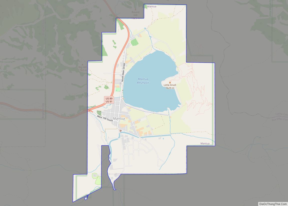
Map of Highland city, Utah

Map of Highland city, Utah

Highland is a city in Utah County, Utah, United States. It is approximately 30 miles (48 km) south of Salt Lake City and is part of the Provo–Orem Metropolitan Statistical Area. According to the 2010 census the population was 15,523, a 90.0% increase over the 2000 figure of 8,172. Highland city overview: Name: Highland city LSAD … Read more

Map of Hideout town

Map of Hideout town

Hideout is a town in the northwestern corner of Wasatch County, Utah, United States, in the northern part of the state. Lying just to the north and east of Jordanelle Reservoir along Utah State Route 248 (SR-248), the town was incorporated in 2008 under short-lived state law. The population was 656 at the 2010 census. … Read more

Map of Herriman city

Map of Herriman city

Herriman (/ˈhɛrɪmən/ HERR-ih-mən) is a city in southwestern Salt Lake County, Utah. The population was 55,144 as of the 2020 census. Although Herriman was a town in 2000, it has since been classified as a fourth-class city by state law. The city has experienced rapid growth since incorporation in 1999, as its population was just … Read more

Map of Henrieville town

Map of Henrieville town

Henrieville is a town in Garfield County, Utah, United States, along Utah Scenic Byway 12. As of the 2010 census, the town population was 230, up from 159 at the 2000 census. The community was named after James Henrie, a Mormon leader. Henrieville town overview: Name: Henrieville town LSAD Code: 43 LSAD Description: town (suffix) … Read more

Map of Henefer town

Map of Henefer town

Henefer (/ˈhɛnəfɜːr/ HEN-ə-fər) is a town in Summit County, Utah, United States. It is part of the Salt Lake City, Utah Metropolitan Statistical Area. The population was 766 at the 2010 census. Henefer town overview: Name: Henefer town LSAD Code: 43 LSAD Description: town (suffix) State: Utah County: Summit County Founded: 1853 Incorporated: 1938 Elevation: … Read more

Map of Helper city

Map of Helper city

Helper is a city in Carbon County, Utah, United States, approximately 110 miles (180 km) southeast of Salt Lake City and 7 miles (11 km) northwest of the city of Price. The population was 2,201 at the 2010 census. The city is located along the Price River and U.S. Route 6/U.S. Route 191, a shortcut between Provo … Read more

Map of Heber city, Utah

Map of Heber city, Utah

Heber city overview: Name: Heber city LSAD Code: 25 LSAD Description: city (suffix) State: Utah County: Wasatch County FIPS code: 4934200 Online Interactive Map Heber online map. Source: Basemap layers from Google Map, Open Street Map (OSM), Arcgisonline, Wmflabs. Boundary Data from Database of Global Administrative Areas. Heber location map. Where is Heber city? Heber … Read more

Map of Holden town, Utah

Map of Holden town, Utah

Holden is a town in Millard County, Utah, United States. The population was 378 at the 2010 census. Holden town overview: Name: Holden town LSAD Code: 43 LSAD Description: town (suffix) State: Utah County: Millard County Incorporated: 1923 Elevation: 5,102 ft (1,555 m) Total Area: 0.54 sq mi (1.39 km²) Land Area: 0.54 sq mi (1.39 km²) Water Area: 0.00 sq mi (0.00 km²) Total Population: … Read more

Map of Hyrum city

Map of Hyrum city

Hyrum is a city in Cache County, Utah. The population was 7,609 at the time of the 2010 census, with an estimated population of 8,403 in 2018. It is included in the Logan metropolitan area. Hyrum city overview: Name: Hyrum city LSAD Code: 25 LSAD Description: city (suffix) State: Utah County: Cache County Elevation: 4,698 ft … Read more

Map of Hyde Park city, Utah

Map of Hyde Park city, Utah

Hyde Park is a city in north-central Cache County, Utah, United States. The population was 3,833 at the 2010 census, with an estimated population of 4,700 in 2018. It is included in the Logan, Utah-Idaho Metropolitan Statistical Area. Hyde Park city overview: Name: Hyde Park city LSAD Code: 25 LSAD Description: city (suffix) State: Utah … Read more

Map of Hurricane city

Map of Hurricane city, Utah

Hurricane (/ˈhɜːrɪkən/ HUR-i-kən) is a city in Washington County, Utah, United States. Its population was 20,036 as of the 2020 United States Census estimates. The Hurricane valley makes up the easternmost part of the St. George Metropolitan area and is becoming a tourist gateway town to Zion National Park. Hurricane is known for its historic … Read more

Map of Huntsville town, Utah

Map of Huntsville town, Utah

Huntsville (Shoshone: Anga-we-ya-dye) is a town in Weber County, Utah, United States. The population was 608 at the 2010 census. It is located in Ogden Valley. It is part of the Ogden–Clearfield, Utah Metropolitan Statistical Area, as well as the Ogden Valley census county division. Huntsville town overview: Name: Huntsville town LSAD Code: 43 LSAD … Read more