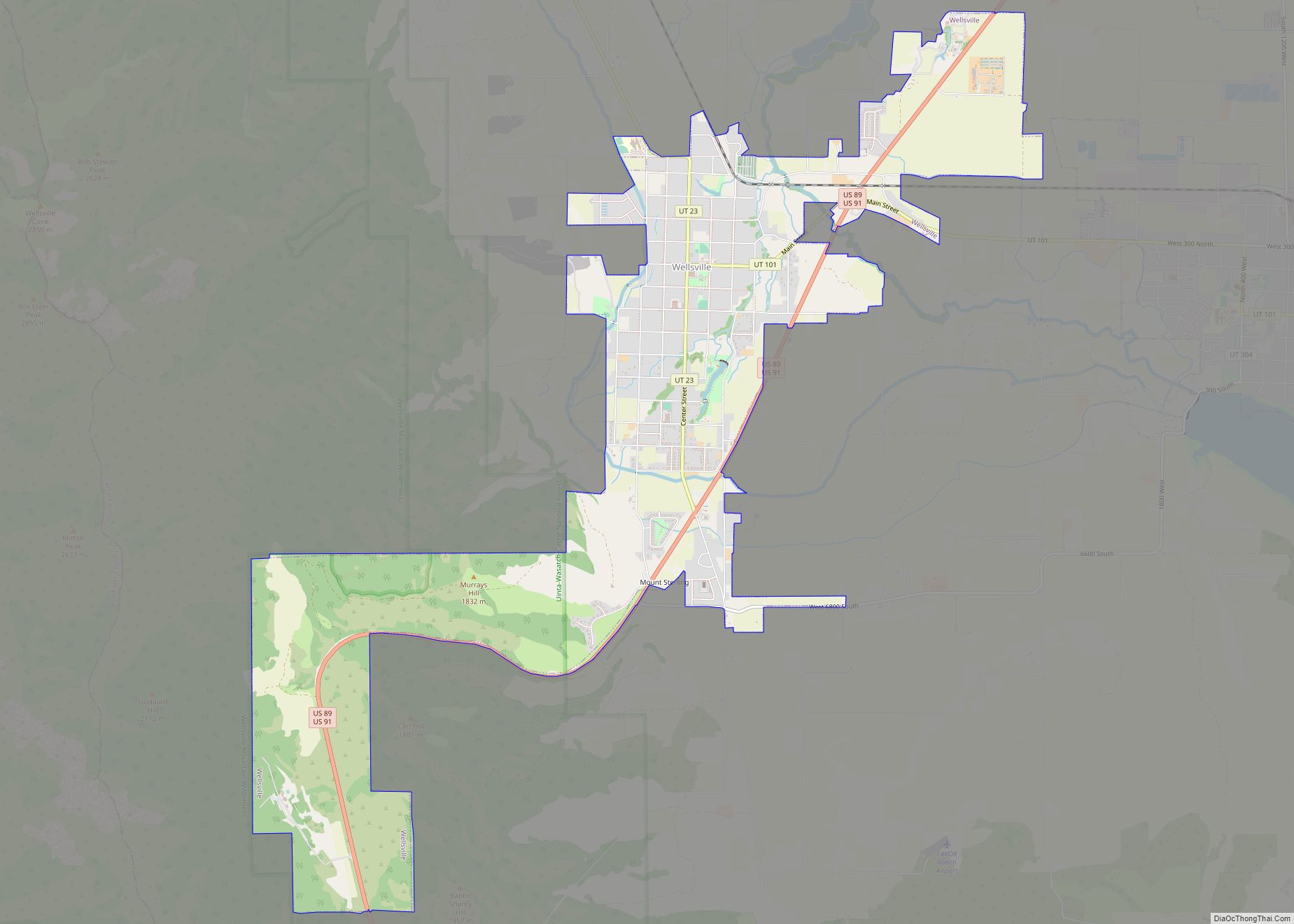
Map of Salem city, Utah

Map of Salem city, Utah

Salem is a city in Utah County, Utah. It is part of the Provo–Orem metropolitan area. The population was 9,298 at the time of the 2020 U.S. census. Landmark locations in Salem include the Dream Mine of John Hyrum Koyle and the Salem Pond. Salem city overview: Name: Salem city LSAD Code: 25 LSAD Description: … Read more

Map of Rush Valley town

Map of Rush Valley town

Rush Valley is a town in Tooele County, Utah, United States, located in the northwest of Rush Valley. It is part of the Salt Lake City, Utah Metropolitan Statistical Area. The population was 447 at the 2010 census, with an estimate population of 494 in 2019. Rush Valley town overview: Name: Rush Valley town LSAD … Read more

Map of Roy city, Utah

Map of Roy city, Utah

Roy is a city in Weber County, Utah, United States, located on the west side of Interstate 15. The population estimate in 2019 was 39,613, an increase of 5.8% from 36,884 at the 2010 Census. It is part of the Ogden−Clearfield, Utah Metropolitan Statistical Area, and is considered a suburb of nearby Ogden, although some … Read more

Map of Scipio town, Utah

Map of Scipio town, Utah

Scipio is a town on the eastern edge of Millard County, Utah, United States. The population was 290 at the 2000 census. Scipio town overview: Name: Scipio town LSAD Code: 43 LSAD Description: town (suffix) State: Utah County: Millard County Elevation: 5,315 ft (1,620 m) Total Area: 1.04 sq mi (2.70 km²) Land Area: 1.04 sq mi (2.70 km²) Water Area: 0.00 sq mi (0.00 km²) … Read more

Map of Saratoga Springs city, Utah

Map of Saratoga Springs city, Utah

Saratoga Springs is a city in Utah County, Utah, United States. The elevation is 4,505 feet. It is part of the Provo–Orem, Utah Metropolitan Statistical Area. The city is a relatively new development along the northwestern shores of Utah Lake. It was incorporated on December 31, 1997 and has been growing rapidly since then. The … Read more

Map of Santaquin city

Map of Santaquin city

Santaquin (/ˈsæntəkwɪn/ SAN-tə-kwin) is a city in Utah and Juab counties in the U.S. state of Utah. It is part of the Provo–Orem metropolitan area. The population was 13,725 at the 2020 census. Santaquin city overview: Name: Santaquin city LSAD Code: 25 LSAD Description: city (suffix) State: Utah County: Juab County, Utah County Incorporated: 1890s … Read more

Map of South Weber city

Map of South Weber city

South Weber (/ˈwiːbər/ WEE-bər) is a city on the northeastern edge of Davis County, Utah, United States. It is part of the Ogden–Clearfield, Utah Metropolitan Statistical Area. The population was 6,051 at the 2010 census, with an estimated population of 7,518 in 2018. South Weber city overview: Name: South Weber city LSAD Code: 25 LSAD … Read more

Map of South Salt Lake city

Map of South Salt Lake city

South Salt Lake is a city in Salt Lake County, Utah, United States and is part of the Salt Lake City Metropolitan Statistical Area. The population was 23,617 at the 2010 census. South Salt Lake city overview: Name: South Salt Lake city LSAD Code: 25 LSAD Description: city (suffix) State: Utah County: Salt Lake County … Read more

Map of South Ogden city

Map of South Ogden city

South Ogden is a city in Weber County, Utah, United States with 17,199 residents. The population was 16,532 at the 2010 census. It is part of the Ogden–Clearfield, Utah Metropolitan Statistical Area. The current mayor is Russell L. Porter. South Ogden city overview: Name: South Ogden city LSAD Code: 25 LSAD Description: city (suffix) State: … Read more

Map of South Jordan city

Map of South Jordan city

South Jordan is a city in south central Salt Lake County, Utah, United States, 18 miles (29 km) south of Salt Lake City. Part of the Salt Lake City metropolitan area, the city lies in the Salt Lake Valley along the banks of the Jordan River between the 10,000-foot (3,000 m) Oquirrh Mountains and the 11,000-foot (3,400 m) … Read more

Map of Snyderville CDP

Map of Snyderville CDP

Snyderville is a census-designated place (CDP) near the southwestern edge of Summit County, Utah, United States. Prior to the 2010 Census, the area was designated as South Snyderville Basin CDP. The population was 3,636 at the 2000 census. Snyderville CDP overview: Name: Snyderville CDP LSAD Code: 57 LSAD Description: CDP (suffix) State: Utah County: Summit … Read more

Map of Snowville town

Map of Snowville town, Utah

Snowville is a town in Box Elder County, Utah, United States. The population was 167 at the 2010 census. Snowville town overview: Name: Snowville town LSAD Code: 43 LSAD Description: town (suffix) State: Utah County: Box Elder County Incorporated: November 6, 1933 Elevation: 4,547 ft (1,386 m) Total Area: 1.55 sq mi (4.02 km²) Land Area: 1.55 sq mi (4.02 km²) Water Area: … Read more