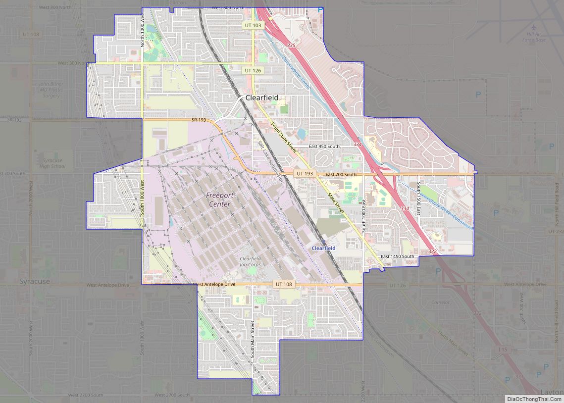
Map of Spring Lake CDP, Utah

Map of Spring Lake CDP, Utah

Spring Lake is a census-designated place (CDP) in southern Utah County, Utah, United States. It is part of the Provo–Orem Metropolitan Statistical Area. The population was 458 at the 2010 census. It is an unincorporated part of Utah County, located just south of Payson and north of Santaquin. Spring Lake CDP overview: Name: Spring Lake … Read more

Map of Spring Glen CDP

Map of Spring Glen CDP

Spring Glen is a census-designated place in Carbon County, in eastern Utah, United States. The population was 1,126 at the 2010 census. Founded in 1878, Spring Glen was the first permanent settlement in what is now Carbon County. First settled principally by white Mormon farmers, the community became much more diverse after about 1890, when … Read more

Map of Teasdale CDP

Map of Teasdale CDP

Teasdale is a census-designated place in western Wayne County, Utah, United States, between the Dixie and Fishlake National Forests and near Capitol Reef National Park. The population was 191 at the 2010 census. Teasdale lies along local roads south of State Route 24, southeast of the town of Loa, the county seat of Wayne County. … Read more

Map of Taylorsville city, Utah

Map of Taylorsville city, Utah

Taylorsville is a city in Salt Lake County, Utah. It is part of the Salt Lake City metropolitan area. The population was 60,448 at the time of the 2020 census. Taylorsville was incorporated from the Taylorsville–Bennion CDP and portions of the Kearns metro township on July 1, 1996. The city is located adjacent to Interstate … Read more

Map of Tabiona town

Map of Tabiona town

Tabiona (/tæbiˈoʊnə/ TAB-ee-OH-nə) is a town in Duchesne County, Utah, United States. It is eighty-six miles southeast of the Salt Lake City metropolitan area. The population was 171 at the 2010 United States Census. Tabiona town overview: Name: Tabiona town LSAD Code: 43 LSAD Description: town (suffix) State: Utah County: Duchesne County Incorporated: 1935 Elevation: … Read more

Map of Syracuse city, Utah

Map of Syracuse city, Utah

Syracuse is a city in Davis County, Utah, United States. It is situated between the Great Salt Lake and Interstate 15, about 30 miles (48 km) north of Salt Lake City. It is part of the Ogden–Clearfield, Utah Metropolitan Statistical Area. The city has seen rapid growth and development since the 1990s. The city population was … Read more

Map of Sutherland CDP, Utah

Map of Sutherland CDP, Utah

Sutherland is a census-designated place in northeastern Millard County, Utah, United States. The population was 165 at the 2010 census. Sutherland CDP overview: Name: Sutherland CDP LSAD Code: 57 LSAD Description: CDP (suffix) State: Utah County: Millard County Founded: 1909 Elevation: 4,626 ft (1,410 m) Total Area: 2.2 sq mi (6 km²) Land Area: 2.2 sq mi (6 km²) Water Area: 0.0 sq mi (0 km²) … Read more

Map of Sunset city, Utah

Map of Sunset city, Utah

Sunset is a city in Davis County, Utah, United States. It is part of the Ogden–Clearfield, Utah Metropolitan Statistical Area. The population was 5,122 at the 2010 census. Sunset emerged as a distinct place in 1916. Sunset city overview: Name: Sunset city LSAD Code: 25 LSAD Description: city (suffix) State: Utah County: Davis County Incorporated: … Read more

Map of Summit CDP, Utah

Map of Summit CDP, Utah

Summit is an unincorporated community and census-designated place (CDP) in east-central Iron County, Utah, United States. The population was 160 at the 2010 census. Summit CDP overview: Name: Summit CDP LSAD Code: 57 LSAD Description: CDP (suffix) State: Utah County: Iron County Elevation: 5,955 ft (1,815 m) Total Area: 0.7 sq mi (1.8 km²) Land Area: 0.7 sq mi (1.8 km²) Water Area: … Read more

Map of Summit Park CDP

Map of Summit Park CDP

Summit Park is a census-designated place (CDP) on the western edge of Summit County, Utah, United States. The population was 6,597 at the 2000 census. Summit Park CDP overview: Name: Summit Park CDP LSAD Code: 57 LSAD Description: CDP (suffix) State: Utah County: Summit County Elevation: 6,886 ft (2,099 m) Total Area: 21.7 sq mi (56.2 km²) Land Area: 21.7 sq mi … Read more

Map of Stockton town, Utah

Map of Stockton town, Utah

Stockton is a town in Tooele County, Utah, United States. It is part of the Salt Lake City, Utah Metropolitan Statistical Area. The population was 616 at the 2010 census. Stockton town overview: Name: Stockton town LSAD Code: 43 LSAD Description: town (suffix) State: Utah County: Tooele County Incorporated: 1901 Elevation: 5,118 ft (1,560 m) Total Area: … Read more

Map of Sterling town, Utah

Map of Sterling town, Utah

Sterling is a town in Sanpete County, Utah, United States. The population was 235 at the 2000 census. Sterling town overview: Name: Sterling town LSAD Code: 43 LSAD Description: town (suffix) State: Utah County: Sanpete County Incorporated: 1934 Elevation: 5,574 ft (1,699 m) Total Area: 0.32 sq mi (0.84 km²) Land Area: 0.32 sq mi (0.84 km²) Water Area: 0.00 sq mi (0.00 km²) Total Population: … Read more