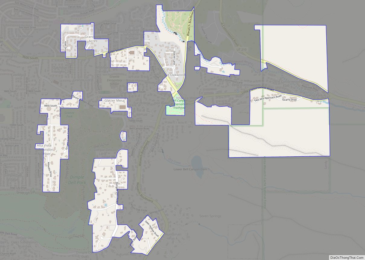
Map of Echo CDP, Utah

Map of Echo CDP, Utah

Echo is a census-designated place located in northwestern Summit County, Utah, United States. The population was 56 at the 2010 census. Echo was founded in 1854. The community took its name from nearby Echo Canyon. Echo CDP overview: Name: Echo CDP LSAD Code: 57 LSAD Description: CDP (suffix) State: Utah County: Summit County Elevation: 5,777 ft … Read more

Map of East Carbon city

Map of East Carbon city

East Carbon is a city in Carbon County, Utah, United States. The population was 1,301 at the 2010 census. East Carbon was incorporated on July 23, 1973, from the merger of the two struggling mining towns of Dragerton and Columbia. On January 1, 2014, the city annexed the neighboring city of Sunnyside. East Carbon city … Read more

Map of Eagle Mountain city

Map of Eagle Mountain city

Eagle Mountain is a city in Utah County, Utah. It is part of the Provo–Orem metropolitan area. The city is located to the west as well as north of the Lake Mountains, which are west of Utah Lake. It was incorporated on 3 December 1996 and had been rapidly growing. The population was 43,623 at … Read more

Map of Dutch John town

Map of Dutch John town

Dutch John is a town located in eastern Daggett County, Utah, United States, approximately 4 miles (6 km) northeast of the Flaming Gorge Dam on U.S. Route 191. The population was 145 at the 2010 census. Dutch John town overview: Name: Dutch John town LSAD Code: 43 LSAD Description: town (suffix) State: Utah County: Daggett County … Read more

Map of Dugway CDP

Map of Dugway CDP

Dugway is a census-designated place (CDP) in southeastern Tooele County, Utah, United States. The population was 2,016, at the 2000 census, a modest increase over the 1990 figure of 1,761. The town is located inside the United States Army’s large weapons testing facility, Dugway Proving Ground, making it a closed city, as the only roads … Read more

Map of Duchesne city

Map of Duchesne city

Duchesne (/duːˈʃeɪn/ doo-SHAYN) is a city in and the county seat of Duchesne County, Utah, United States. The population was 1,588 at the 2020 census. Duchesne city overview: Name: Duchesne city LSAD Code: 25 LSAD Description: city (suffix) State: Utah County: Duchesne County Elevation: 5,518 ft (1,682 m) Total Area: 2.80 sq mi (7.26 km²) Land Area: 2.80 sq mi (7.26 km²) Water … Read more

Map of Elsinore town

Map of Elsinore town

Elsinore is a town in Sevier County, Utah, United States. The population was 847 at the 2010 census. Elsinore town overview: Name: Elsinore town LSAD Code: 43 LSAD Description: town (suffix) State: Utah County: Sevier County Elevation: 5,351 ft (1,631 m) Total Area: 1.33 sq mi (3.46 km²) Land Area: 1.33 sq mi (3.46 km²) Water Area: 0.00 sq mi (0.00 km²) Total Population: 847 Population … Read more

Map of Eureka city, Utah

Map of Eureka city, Utah

Eureka is a city in Juab County, Utah, United States. It is part of the Provo–Orem metropolitan area. The population was 669 at the 2010 census, down from 766 in 2000. The city was named from the Greek word eureka, meaning “I have found it!” Eureka city overview: Name: Eureka city LSAD Code: 25 LSAD … Read more

Map of Escalante city

Map of Escalante city

Escalante (locally /ˌɛskəˈlænt(i)/ (listen)) is a city in central Garfield County, Utah, United States, located along Utah Scenic Byway 12 (SR-12) in the south-central part of the state. As of the 2010 census, 797 people were living in the city. The city is named after Silvestre Vélez de Escalante, a Franciscan missionary and a member … Read more

Map of Erda CDP

Map of Erda CDP

Erda (/ˈɜːrdə/ UR-də) is a city in Tooele County, Utah, United States. The population was 4,642 at the 2010 census, a significant increase from the 2000 figure of 2,473. Erda was previously a Census Designated Place (CDP) and a township but officially received its incorporation certificate in January 2022. Erda CDP overview: Name: Erda CDP … Read more

Map of Ephraim city

Map of Ephraim city, Utah

Ephraim is a city in Sanpete County, Utah, United States. The population was 5,611 at the 2020 census, making it the largest city in Sanpete County. It is the location of Snow College and is located along U.S. Route 89. Ephraim city overview: Name: Ephraim city LSAD Code: 25 LSAD Description: city (suffix) State: Utah … Read more

Map of Enterprise CDP, Utah

Map of Enterprise CDP, Utah

Enterprise is a census-designated place (CDP) in northwestern Morgan County, Utah, United States. The population was 605 at the 2010 census. Enterprise CDP overview: Name: Enterprise CDP LSAD Code: 57 LSAD Description: CDP (suffix) State: Utah County: Morgan County Elevation: 5,246 ft (1,599 m) Total Area: 3.8 sq mi (10 km²) Land Area: 3.8 sq mi (10 km²) Water Area: 0.0 sq mi (0 km²) Total … Read more