Map of Gloucester Courthouse CDP
Gloucester Courthouse is a census-designated place (CDP) in and the county seat of Gloucester County, Virginia, United States. The population was 2,951 at the 2010 census. Gloucester Courthouse CDP overview: Name: Gloucester Courthouse CDP LSAD Code: 57 LSAD Description: CDP (suffix) State: Virginia County: Gloucester County Elevation: 33 ft (10 m) Total Area: 7.2 sq mi (18.6 km²) Land Area: ... Read more
Map of Gloucester Courthouse CDP
Map of Glenvar CDP
Glenvar CDP overview: Name: Glenvar CDP LSAD Code: 57 LSAD Description: CDP (suffix) State: Virginia County: Roanoke County FIPS code: 5131488 Online Interactive Map Glenvar online map. Source: Basemap layers from Google Map, Open Street Map (OSM), Arcgisonline, Wmflabs. Boundary Data from Database of Global Administrative Areas. Glenvar location map. Where is Glenvar CDP? Glenvar ... Read more
Map of Glenvar CDP
Map of Glen Lyn town
Glen Lyn is a town in Giles County, Virginia, United States, at the confluence of the East and New rivers. The population was 115 at the 2010 census, down from 151 at the 2000 census. It is part of the Blacksburg–Christiansburg Metropolitan Statistical Area. Glen Lyn town overview: Name: Glen Lyn town LSAD Code: 43 ... Read more
Map of Glen Lyn town
Map of Glasgow town, Virginia
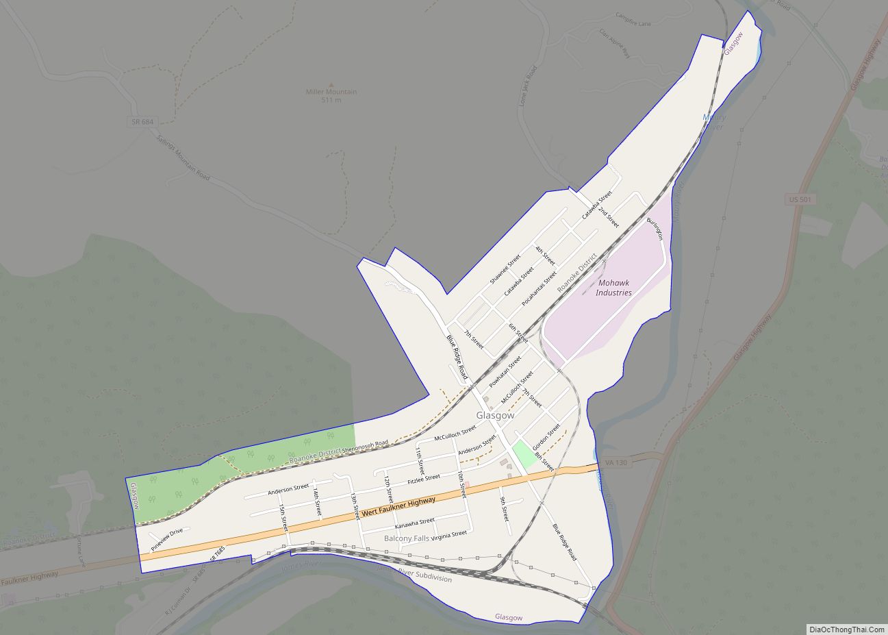
Glasgow is a town in Rockbridge County, Virginia, United States, at the confluence of the James and Maury Rivers. The population was 1,133 at the 2010 census. Glasgow has had issues with flooding, notably during Hurricane Camille in 1969. As a result of flooding concerns, the Balcony Falls Dam (just east of the confluence of ... Read more
Map of Glasgow town, Virginia
Map of Great Falls CDP, Virginia
Great Falls is a census-designated place (CDP) in Fairfax County, Virginia, United States. The population as of the 2010 census was 15,427, an increase of 80.5% from the 2000 census. Great Falls CDP overview: Name: Great Falls CDP LSAD Code: 57 LSAD Description: CDP (suffix) State: Virginia County: Fairfax County Elevation: 344 ft (105 m) Total Area: ... Read more
Map of Great Falls CDP, Virginia
Map of Gwynn CDP
Gwynn is a census-designated place (CDP) in Mathews County, Virginia, United States. The population as of the 2010 Census was 602. Gwynn is located on Gwynn’s Island 5 miles (8.0 km) north-northeast of Mathews. Gwynn has a post office with ZIP code 23066. Gwynn CDP overview: Name: Gwynn CDP LSAD Code: 57 LSAD Description: CDP (suffix) ... Read more
Map of Gwynn CDP
Map of Grundy town
Grundy is a town in Buchanan County, Virginia, United States, an area located within the Appalachian Mountains region. It is the county seat of Buchanan County. The town is home to the Appalachian School of Law. The population was 875 as of the 2020 census. Legislation establishing Buchanan County in 1858 designated a plat of ... Read more
Map of Grundy town
Map of Groveton CDP, Virginia
Groveton is a census-designated place (CDP) in Fairfax County, Virginia, United States. The population was 14,598 at the 2010 census, down from 21,296 in 2000 due to a reduction in area. Located south of the city of Alexandria, it encompasses numerous neighborhoods including Groveton, Bucknell Manor, Stoneybrooke, and portions of Hollin Hills. Huntley Meadows Park, ... Read more
Map of Groveton CDP, Virginia
Map of Gretna town, Virginia
Gretna is a town in Pittsylvania County, Virginia, United States. The population was 1,267 at the 2010 census. It is part of the Danville Metropolitan Statistical Area. Gretna town overview: Name: Gretna town LSAD Code: 43 LSAD Description: town (suffix) State: Virginia County: Pittsylvania County Elevation: 833 ft (254 m) Total Area: 1.69 sq mi (4.38 km²) Land Area: 1.67 sq mi ... Read more
Map of Gretna town, Virginia
Map of Greenbush CDP, Virginia
Greenbush is a census-designated place (CDP) in Accomack County, Virginia, United States. Per the 2020 census, the population was 224. Hills Farm was added to the National Register of Historic Places in 2008. Greenbush CDP overview: Name: Greenbush CDP LSAD Code: 57 LSAD Description: CDP (suffix) State: Virginia County: Accomack County Elevation: 13 m (43 ft) Total ... Read more
Map of Greenbush CDP, Virginia
Map of Greenbriar CDP, Virginia
Greenbriar is a census-designated place in Fairfax County, Virginia, United States. The population as of the 2010 census was 8,166. The community between Fairfax City and Chantilly dates from the late 1960s, when it was developed by Levitt & Sons. The community is famous for having only one road within its territory that does not ... Read more
Map of Greenbriar CDP, Virginia
Map of Greenbackville CDP
Greenbackville is a census-designated place (CDP) 4.5 miles (5 km) south of Stockton, Maryland in Accomack County, Virginia, located just south of the Maryland state line. Per the 2020 census, the population was 173. Greenbackville CDP overview: Name: Greenbackville CDP LSAD Code: 57 LSAD Description: CDP (suffix) State: Virginia County: Accomack County Elevation: 0 m (0 ft) Total ... Read more
Map of Greenbackville CDP